Ammertenhorn
| Ammertenhorn | ||
|---|---|---|
|
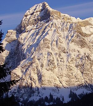
Northwest and west face of the Ammertenhorn in the evening light |
||
| height | 2666 m above sea level M. | |
| location | Bern , Switzerland | |
| Mountains | Bernese Alps | |
| Dominance | 0.96 km → Wildstrubel | |
| Notch height | 73 m ↓ unnamed notch | |
| Coordinates | 606 045 / 140645 | |
|
|
||
The Ammertenhorn or Ammertehore is a 2666 m above sea level. M. high mountain in the former district of Obersimmental in the canton of Bern . From an administrative point of view, it belongs to the Frutigen-Niedersimmental administrative district . The Ammertenhorn forms a western branch of the Wildstrubel and is part of the Bernese Alps (Western Alps) mountain group .
Name and access
Ammertenhorn is the written German name, Ammertehore the Swiss German. The ascent to the Ammertenhorn is possible from the southeast against the backdrop of the Wildstrubelnordcouloir.
Similar names
- Ammerten Pass
- Ammertenäli
- Ammertenspitz
- Ammertenbach, Ammertengrat
- Ammerten glacier
height
The higher peak is the east peak with a height of 2666 m above sea level. M. , the west summit, which closes the striking, up to 1000 meter high wall formations of the northwest and west walls, reaches 2652 m above sea level. M.
Web links
Individual evidence
- ↑ a b c Ammertenhorn on GeoFinder.ch
- ^ Charles Knapp, Maurice Borel, Victor Attinger, Heinrich Brunner, Société neuchâteloise de geographie (editor): Geographical Lexicon of Switzerland . Volume 1: Aa - Emmengruppe . Verlag Gebrüder Attinger, Neuenburg 1902, p. 71, keyword Ammertenhorn ( scan of the lexicon page ).
- ↑ http://www.hikr.org/tour/post15827.html
- ↑ http://www.hikr.org/tour/post26779.html
- ↑ limited preview in the Google book search

