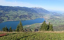
Sarneraatal
The Sarneraatal is the main valley in the canton of Obwalden in central Switzerland . It extends from the Brünig Pass to 1008 m above sea level. M. about 30 kilometers in a northeasterly direction to Acheregg near Stansstad , where the Alpnachersee at 434 m above sea level. M. flows into Lake Lucerne . The Sarner Aa flows through the valley .
geography
Starting at the Brünig Pass at 1008 m above sea level. M. the valley is initially relatively narrow and falls over the Brünigboden ( also called Chäppeli because of the Burgkappele ) to an altitude of about 700 m above sea level. M. There follows an approximately four kilometer long intermediate height with Lungern and the Lungerersee . The surface water seeps away from the Brünig Pass to the Burgkappele. The largest inlet to the Lungerersee is the Lungerer Lauibach , on the left of the Brünigpass in the direction of flow. It thus forms the upper reaches of the Sarner Aa. The Lungerersee has been running through tunnels since the early 19th century.
After Lungerersee the area falls in Kaiser chair in a second stage from the actual bottom of the valley, the at Giswil to 484 m above sea level. M. begins. In the further course the Sarner Aa flows through the Sarnersee and the Wichelsee and finally flows into the Alpnachersee, a bay of the Vierwaldstättersee . The valley towns of Sachseln , Sarnen , Kägiswil , Alpnach and Alpnachstad follow in the same vein .
The confluence of the Alpnachersee in the Vierwaldstättersee forms the lower end of the valley. Here, the Lopper , coming from the west from the Pilatus, pushes itself like a bolt into the valley and thus shields it from the Horwerbucht of Lake Lucerne behind . In the east, Stansstad forms the end of the valley. In a broader sense, the Pilatus and the Stanserhorn can also be viewed as the northern boundary mountains of the valley, as these limit the Alpnachersee to the west and east, visible from afar.
Side valleys are the Kleine Melchtal and the Melchtal with the Ranft gorge on the right (eastern) side of the valley . On the left (western) side of the valley, the valley cuts of the Giswiler Lauibach , the Grosse Schliere and the Kleiner Schliere flow into the Sarneraatal.
The geographic center of Switzerland is on the Älggi-Alp on the eastern flank of the valley .
Flow paths
Although the Lungerersee, the deepest of the converging valleys, is the main valley, the waters of other valleys have longer flow paths: The Melchtal has the longest with the Great Melchaa , from the rear end of the Tannensee to the outflow of the Sarnersee, the water needs over 23 km. From the longest source brooks of the Giswil Lauibach (also: Laui ) it is over 19 km, from the source of the Lungerer Lauibach (also Laui Lungern for short ) it is less than 19 km, from the source on the Summerweid under the Brünig Pass it is only 15 km, in parts through natural seepage underground.
meteorology
The Sarneraatal is one of the typical Foehn valleys in Switzerland, as it essentially runs in a south-north direction.
literature
- National map of Switzerland : Composition 1: 50,000, sheet 5023, Entlebuch-Pilatus-Engelberg , ISBN 978-3-302-05023-2
Web links
- Sarneraatal: Journey to the center of Switzerland , TV broadcast in the SRF bi de Lüt series - Wonderland of Swiss radio and television from May 15, 2015
- Sarneraatal (OW) - More about the region of the 1st broadcast of “SRF bi de Lüt - Wunderland” 2015 , on the website of Swiss radio and television
Individual evidence
- ↑ FOEN / Swisstopo Vektor25 water network , map section with no. 812 By clicking on it, data sets from name, GEWISS no. and section length available.
- ↑ FOEN / Swisstopo Vektor25 water network , map excerpt with no. 810 and 3193 By clicking on it, data records from name, GEWISS no. and section length available.
- ↑ Der Föhn , on the Meteo Schweiz website , accessed on June 12, 2016
Coordinates: 46 ° 52 ' N , 8 ° 13' E ; CH1903: 659399 / 191029


