
Brunegg
| Brunegg | |
|---|---|
 |
|
| State : |
|
| Canton : |
|
| District : | Lenzburg |
| BFS no. : | 4193 |
| Postal code : | 5505 |
| UN / LOCODE : | CH BNG |
| Coordinates : | 658 734 / 252306 |
| Height : | 425 m above sea level M. |
| Height range : | 380-581 m above sea level M. |
| Area : | 1.55 km² |
| Residents: | 876 (December 31, 2019) |
| Population density : | 565 inhabitants per km² |
|
Proportion of foreigners : (residents without citizenship ) |
22.7% (December 31, 2019) |
| Website: | www.brunegg.ch |
 Farmhouse in the village center |
|
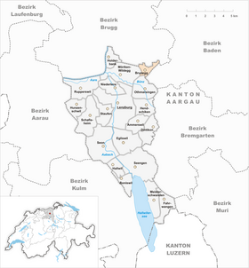
| Location of the municipality | |
  |
|
Brunegg is a municipality in the Swiss canton of Aargau . It belongs to the Lenzburg district and lies between the Reuss valley and the lower Bünztal .
geography
The cluster village is located on the southern edge of the flat Birrfeld , a little more than two kilometers west of the Reuss and just under one and a half kilometers northeast of the Bünz. At the edge of the village, the eastern flank of the Chestenberg rises steeply into the air. This foothills of the Folded Jura , up to 647 meters high, has a narrow rocky ridge that extends westward over a length of four kilometers to Wildegg Castle and almost to the Aare .
The area of the municipality is 155 hectares , of which 40 hectares are forested and 50 hectares are built over. The highest point is at 590 meters on the ridge of the Chestenberg, the deepest at 409 meters on the northeastern municipal boundary. The neighboring communities of Brunegg are Birr in the north, Birrhard in the northeast, Mägenwil in the southeast, Othmarsingen in the south and Möriken-Wildegg in the west.
history
The first mention of Brunegge comes from the year 1273. The place name comes from the Old High German (ze dero) brunun ekko and means "at the brown mountain ridge". The village owes its existence to the castle of the same name , which was built in the 13th century. It served to protect the south side of the Habsburg heartland, the Eigenamt , and was inhabited by ministerials . The lower jurisdiction over the village was in the hands of the respective castle residents.

When the Swiss conquered Aargau in 1415, the Brunegg was one of the few castles that offered resistance. From then on , the village belonged to the subject area of the city of Bern , the so-called Berner Aargau, and was assigned to the judicial district of Othmarsingen in the Lenzburg district. In 1528 the Bernese introduced the Reformation . In March 1798 the French took Switzerland, ousted the «Gracious Lords» of Bern and proclaimed the Helvetic Republic . Since then Brunegg has belonged to the canton of Aargau.
The community was initially part of the Brugg district , but was then assigned to the Lenzburg district in 1840 . When the Hendschiken - Brugg line of the Aargau Southern Railway opened on June 1, 1882 , Brunegg did not have its own train station. Five years earlier, the municipality had refused to participate financially in the national railway and therefore did not have to bear the follow-up costs of the bankruptcy. The village was dominated by agriculture until well into the 20th century ; some viticulture was practiced on the Chestenberg . After the opening of the nearby motorway in 1970, the community experienced an economic boom. The population has almost tripled since 1980.
Attractions

Around 120 meters above the village, on a steep rock spur at the eastern end of the Chestenberg ridge, there is Brunegg Castle , a 13th century castle. The complex, which has been converted into a residential palace, consists of the main castle with a residential wing from the early days, a garden from the 19th century and two utility buildings. The most famous lord of the castle was the historian Jean Rudolf von Salis . Brunegg only received its own Reformed church in 1967 ; originally the village belonged to the parish of Windisch , from 1526 to the parish of Birr .
coat of arms
The blazon of the municipal coat of arms reads: "In white blue eight-pointed lily scepter star." The coat of arms appears for the first time in 1548 in a Bern chronicle and is also used on the municipal seal from 1822. On a coat of arms created in 1902 in the church of Birr, the scepter appears in red on white. The municipal council confirmed the form in use today in 1953.
population
The population developed as follows:
| year | 1798 | 1850 | 1900 | 1930 | 1950 | 1960 | 1970 | 1980 | 1990 | 2000 | 2010 |
| Residents | 180 | 277 | 244 | 275 | 297 | 292 | 327 | 299 | 354 | 466 | 671 |
On December 31, 2019, 876 people lived in Brunegg, the proportion of foreigners was 22.7%. In the 2015 census, 33.2% described themselves as Reformed and 30.6% as Roman Catholic ; 36.2% were non-denominational or of other faiths. 94.2% said German as their main language in the 2000 census and 2.4% Italian .
Politics and law
The assembly of those entitled to vote, the municipal assembly , exercises legislative power. The executing authority is the five-member municipal council . He is elected by the people in the majority procedure, his term of office is four years. The parish council leads and represents the parish. To this end, it implements the resolutions of the municipal assembly and the tasks assigned to it by the canton. The District Court of Lenzburg is the first instance responsible for legal disputes . Brunegg belongs to the Friedensrichterkreis XI (Lenzburg).
economy
According to the company structure statistics (STATENT) collected in 2015, there are around 540 jobs in Brunegg, 3% of them in agriculture, 19% in industry and 78% in the service sector. The most important employers include a paper mill, a door factory, a gravel works, several logistics companies and a cattle auction hall.
traffic
Brunegg has excellent transport connections. To the east of the village, Kantonsstrasse 280 runs between Wohlen and Brugg . This is where the Mägenwil junction of the A1 motorway is located . Four kilometers further north is the Brugg connection to the A3 . Although the Lenzburg - Brugg railway runs right past the village, there is no stop here. Instead, a bus line operated by Regionalbus Lenzburg leads to the train stations in Lenzburg and Mägenwil. On weekends there is a night bus from Lenzburg via Brunegg to Othmarsingen .
education
The community has a kindergarten and a school house where primary school is taught. All upper levels ( Realschule , Secondary School and District School ) can be attended in Möriken-Wildegg . The closest grammar schools are the Alte Kantonsschule and the Neue Kantonsschule , both in Aarau .
literature
- Andreas Steigmeier : Brunegg. In: Historical Lexicon of Switzerland .
- Michael Stettler , Emil Maurer : The art monuments of the canton of Aargau . Ed .: Society for Swiss Art History . Volume II: The districts of Lenzburg, Brugg. Wiese Verlag, Basel 1953, DNB 750561750 .
Web links
Individual evidence
- ↑ Cantonal population statistics 2019. Department of Finance and Resources, Statistics Aargau, March 30, 2020, accessed on April 2, 2019 .
- ↑ Cantonal population statistics 2019. Department of Finance and Resources, Statistics Aargau, March 30, 2020, accessed on April 2, 2019 .
- ^ National map of Switzerland, sheet 1090, Swisstopo.
- ↑ Standard area statistics - municipalities according to 4 main areas. Federal Statistical Office , November 26, 2018, accessed on May 21, 2019 .
- ^ Beat Zehnder: The community names of the canton of Aargau . In: Historical Society of the Canton of Aargau (Ed.): Argovia . tape 100 . Verlag Sauerländer, Aarau 1991, ISBN 3-7941-3122-3 , p. 113-114 .
- ^ Joseph Galliker, Marcel Giger: Municipal coat of arms of the Canton of Aargau . Lehrmittelverlag des Kantons Aargau, book 2004, ISBN 3-906738-07-8 , p. 133 .
- ↑ Population development in the municipalities of the Canton of Aargau since 1850. (Excel) In: Eidg. Volkszählung 2000. Statistics Aargau, 2001, archived from the original on October 8, 2018 ; accessed on May 21, 2019 .
- ↑ Resident population by religious affiliation, 2015. (Excel) In: Population and Households, Community Tables 2015. Statistics Aargau, accessed on May 21, 2019 .
- ↑ Swiss Federal Census 2000: Economic resident population by main language as well as by districts and municipalities. (Excel) Statistics Aargau, archived from the original on August 10, 2018 ; accessed on May 21, 2019 .
- ↑ circles of justice of the peace. Canton of Aargau, accessed on June 20, 2019 .
- ↑ Statistics of the corporate structure (STATENT). (Excel, 157 kB) Statistics Aargau, 2016, accessed on May 21, 2019 .
Ammerswil | Boniswil | Brunegg | Dintikon | Egliswil | Fahrwangen | Hallwil | Hendschiken | Holderbank | Hunzenschwil | Lenzburg | Meisterschwanden | Möriken-Wildegg | Niederlenz | Othmarsingen | Rupperswil | Schafisheim | Seengen | Seon | Staufen
Former municipalities: Alliswil | Retterswil | Tennwil
Canton of Aargau | Districts of the Canton of Aargau | Municipalities in the Canton of Aargau