Rupperswil
| Rupperswil | |
|---|---|
| State : |
|
| Canton : |
|
| District : | Lenzburg |
| BFS no. : | 4206 |
| Postal code : | 5102 |
| UN / LOCODE : | CH RPP |
| Coordinates : | 652 015 / 250457 |
| Height : | 374 m above sea level M. |
| Height range : | 348–404 m above sea level M. |
| Area : | 6.22 km² |
| Residents: | 5485 (December 31, 2019) |
| Population density : | 882 inhabitants per km² |
|
Proportion of foreigners : (residents without citizenship ) |
21.6% (December 31, 2019) |
| Website: | www.rupperswil.ch |
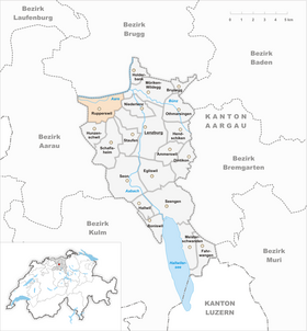
| Location of the municipality | |
Rupperswil ( ˌrʊbiʃˈʋiːl in the local dialect ) is a municipality in the Swiss canton of Aargau . It belongs to the Lenzburg district and is located south of the Aare between Lenzburg and the canton capital, Aarau .
geography
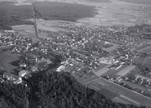
The cluster village is located in a large clearing between the Suretwald in the west and the Länzertwald in the east. Rupperswil is therefore a typical clearing settlement . The landscape is slightly inclined towards the north and has no major elevations. The eastward flowing Aare forms the northern boundary of the municipality. South of the river runs the three-kilometer-long canal of the former Steiner spinning mill , which goes back to an earlier branch of the Aare. The Geissenschachen forest area between the Aare and the Steinerkanal is two and a half kilometers long and up to 350 meters wide.
The area of the municipality is 622 hectares , of which 220 hectares are forested and 194 hectares are built over. The highest point is at 401 meters in the southeast of the municipality, the deepest at 350 meters on the Aare. Neighboring communities are Auenstein in the north, Möriken-Wildegg in the northeast, Niederlenz and Lenzburg in the east, Staufen in the southeast, Schafisheim and Hunzenschwil in the south, Suhr in the southwest and Buchs and Aarau in the west.
history
In 1911 a Roman brick kiln was found in the Zozeläckern . Various brick fragments indicate its use in the early 2nd century. The plant is related to a larger one near Hunzenschwil . The first traces of settlement date from the middle of the 8th century, when Alemannic farmers cleared a large area in the Länzertwald and the Suretwald and made it arable. The first written mention of Rubiswile took place in 1173, when the sovereignty and blood jurisdiction were passed from the Counts of Lenzburg to the Counts of Kyburg . The place name comes from the Old High German Rubineswilari and means "court settlement of the Rubin".
The Habsburgs followed the Kyburger in 1273 . The lower jurisdiction was owned by the Lords of Rupperswil. This family, which died out in the 14th century, was followed by the Hallwylers . In 1415 the confederates conquered Aargau. Rupperswil now belonged to the subject area of the city of Bern , the so-called Berner Aargau, and was the capital of a judicial district in the Lenzburg district . In 1521, the Hallwylers left their rights in Rupperswil to the city of Bern and extended their judicial powers in Schafisheim . In 1528 the Bernese introduced the Reformation . In church matters, Rupperswil belonged to the parish of Suhr for a long time . After years of efforts, the village formed its own parish from 1681. In March 1798 the French took Switzerland, ousted the «Gracious Lords» of Bern and proclaimed the Helvetic Republic . Since then, Rupperswil has belonged to the canton of Aargau.
For centuries the villagers had to struggle with the floods of the untamed Aare . Between 1865 and 1873 they straightened the river and built flood protection dams . The connection to the railway network took place on May 15, 1858, when the Swiss Northeast Railway opened the Aarau - Brugg line with a train station in Rupperswil. On June 23, 1874 the route of the Aargau Southern Railway to Wohlen followed , which was extended to Arth-Goldau until 1881 and thus created a connection to the Gotthard Railway . The construction of the railways favored the economic development of the village. The Rupperswil-Auenstein power plant was built in 1942 . The population has increased fivefold since 1900, with growth being particularly pronounced in the 1950s and 1980s. In 2015/16, the quadruple murder in Rupperswil made international headlines.
Attractions
In the 13th century a Romanesque chapel was built, which was decorated with Gothic elements around 1500 and expanded into a church. Nevertheless, the building turned out to be too small, which is why it was demolished in 1922 and replaced by a new building; the interior furnishings were largely preserved. The rectory built in 1681 stands next to the new reformed church . The Rupperswil Village Museum is housed in an old farmhouse and shows handicraft tools and other objects from centuries past in changing exhibitions.
coat of arms
The blazon of the municipal coat of arms reads: "In white, blue diagonal bars." A white horse on a red background was featured on the municipal coat of arms since the early 19th century. But because the coat of arms looked similar to that of Lengnau and the sugar mill based in Rupperswil still uses it today (in a modified form) as the company logo, the municipality has had the traditional coat of arms of the Lords of Rupperswil since 1949, which has existed since at least 1334.
population
The population developed as follows:
| year | 1764 | 1798 | 1850 | 1900 | 1930 | 1950 | 1960 | 1970 | 1980 | 1990 | 2000 | 2010 |
| Residents | 308 | 576 | 993 | 1095 | 1607 | 1998 | 2521 | 2947 | 2773 | 3305 | 3770 | 4398 |
On December 31, 2019, 5,485 people lived in Rupperswil, the proportion of foreigners was 21.6%. In the 2015 census, 34.2% described themselves as Reformed and 22.7% as Roman Catholic ; 43.1% were non-denominational or of other faiths. In the 2000 census, 88.2% named German as their main language, 3.7% Italian , 2.1% Serbo-Croatian , 1.5% Turkish , 1.4% Albanian and 0.6% Spanish .
Politics and law
The assembly of those entitled to vote, the municipal assembly , exercises legislative power. The executing authority is the five-member municipal council . He is elected by the people in the majority procedure, his term of office is four years. The parish council leads and represents the parish. To this end, it implements the resolutions of the municipal assembly and the tasks assigned to it by the canton. The District Court of Lenzburg is the first instance responsible for legal disputes . Rupperswil belongs to the Friedensrichterkreis XII (Seon).
economy
According to the corporate structure statistics (STATENT) collected in 2015, Rupperswil has around 2100 jobs, of which 1% in agriculture, 44% in industry and 55% in the service sector. One of Switzerland's two sugar mills , in which raw sugar is refined and packaged, is located in the municipality . A window factory is also important , as is part of the Wildegger cement factory . Many employed people are commuters and work in the local area, for example in Lenzburg or Aarau .
traffic
Rupperswil is extremely conveniently located. One and a half kilometers south of the village center is the Aarau-Ost connection to the A1 motorway . From there the motorway-like road T5 leads to the city center of Aarau . The main road 5 connects Aarau with Brugg , the canton road 288 leads to Hunzenschwil . The station is on the east-west main line Bern - Zurich , with the two branches branching out via Lenzburg - Heitersberg and Brugg - Baden ( Baden - Aarau railway line ). Trains to Aarau, Arth-Goldau , Baden, Olten and Zurich stop . A bus line operated by Regionalbus Lenzburg leads via Hunzenschwil to Lenzburg train station. On weekends there is a night S-Bahn ( Winterthur –Zürich HB – Baden – Lenzburg – Aarau) and a night bus from Aarau train station via Rupperswil to Lenzburg.
In 2019, the voters accepted the introduction of Tempo 30 on all municipal roads.
education
The community has three kindergartens and two school houses in which the primary school , the junior high school and the secondary school are taught. The district school can be attended in Lenzburg or Wildegg . The closest grammar schools are the Alte Kantonsschule and the Neue Kantonsschule , both in Aarau .
Personalities
- Lys Assia (1924–2018), singer and actress
- Hans Richner (* 1944), physicist and meteorologist
- Eduard Vischer (1903–1996), historian
literature
- Dominik Sauerländer: Rupperswil. In: Historical Lexicon of Switzerland .
- Michael Stettler , Emil Maurer : The art monuments of the canton of Aargau . Ed .: Society for Swiss Art History . Volume II: The districts of Lenzburg, Brugg. Wiese Verlag, Basel 1953, DNB 750561750 .
Web links
Individual evidence
- ↑ Cantonal population statistics 2019. Department of Finance and Resources, Statistics Aargau, March 30, 2020, accessed on April 2, 2019 .
- ↑ Cantonal population statistics 2019. Department of Finance and Resources, Statistics Aargau, March 30, 2020, accessed on April 2, 2019 .
- ↑ a b Beat Zehnder: The community names of the canton of Aargau . In: Historical Society of the Canton of Aargau (Ed.): Argovia . tape 100 . Verlag Sauerländer, Aarau 1991, ISBN 3-7941-3122-3 , p. 367-368 .
- ^ National map of Switzerland, sheet 1089, Swisstopo.
- ↑ Standard area statistics - municipalities according to 4 main areas. Federal Statistical Office , November 26, 2018, accessed on May 21, 2019 .
- ^ Martin Hartmann, Hans Weber: The Romans in Aargau . Verlag Sauerländer, Aarau 1985, ISBN 3-7941-2539-8 , p. 196-197 .
- ↑ Rupperswil Village Museum
- ^ Joseph Galliker, Marcel Giger: Municipal coat of arms of the Canton of Aargau . Lehrmittelverlag des Kantons Aargau, book 2004, ISBN 3-906738-07-8 , p. 261 .
- ↑ Population development in the municipalities of the Canton of Aargau since 1850. (Excel) In: Eidg. Volkszählung 2000. Statistics Aargau, 2001, archived from the original on October 8, 2018 ; accessed on May 21, 2019 .
- ↑ Resident population by religious affiliation, 2015. (Excel) In: Population and Households, Community Tables 2015. Statistics Aargau, accessed on May 21, 2019 .
- ↑ Swiss Federal Census 2000: Economic resident population by main language as well as by districts and municipalities. (Excel) Statistics Aargau, archived from the original on August 10, 2018 ; accessed on May 21, 2019 .
- ↑ circles of justice of the peace. Canton of Aargau, accessed on June 21, 2019 .
- ↑ Statistics of the corporate structure (STATENT). (Excel, 157 kB) Statistics Aargau, 2016, accessed on May 21, 2019 .
- ↑ Sugar Mill Rupperswil
- ^ Daniel Vizentini: Also at the urn: Tempo 30 is accepted. In: aargauerzeitung.ch . October 20, 2019, accessed October 26, 2019 .


