
Niederlenz
| Niederlenz | |
|---|---|
 |
|
| State : |
|
| Canton : |
|
| District : | Lenzburg |
| BFS no. : | 4204 |
| Postal code : | 5702 |
| UN / LOCODE : | CH NLZ |
| Coordinates : | 655 682 / 250479 |
| Height : | 374 m above sea level M. |
| Height range : | 350-431 m above sea level M. |
| Area : | 3.31 km² |
| Residents: | 4772 (December 31, 2019) |
| Population density : | 1442 inhabitants per km² |
|
Proportion of foreigners : (residents without citizenship ) |
28.7% (December 31, 2019) |
| Website: | www.niederlenz.ch |
 Niederlenz |
|
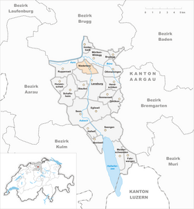
| Location of the municipality | |
  |
|
Niederlenz ( Swiss German : ˈnɪdərˌlænts ) is a municipality in the Swiss canton of Aargau . It belongs to the district of Lenzburg and is located in the center of the canton in the lower Seetal , two kilometers north of the district capital.
geography
The terrain is characterized by a flat plateau. The Aabach flows through a narrow channel, which is hardly more than 20 meters deep, in a northerly direction and divides the village into two roughly equal halves. Larger surveys are completely absent. In 1977 a calculation showed that the geographical center of the canton of Aargau is in the Lenzhardwald northwest of the village center (coordinates 654217/251240). This point has since been marked with a boulder . The municipalities of Niederlenz, Lenzburg and Staufen have grown together to form a coherent agglomeration with almost 20,000 inhabitants, the boundaries between the three places are barely recognizable. The northern municipal boundary extends to the edge of the village of Wildegg.
The area of the municipality is 331 hectares , of which 90 hectares are forested and 155 hectares are built over. The highest point is at 430 meters on the south-eastern municipality boundary, the lowest at 355 meters on the Aabach. Neighboring communities are Möriken-Wildegg in the north, Lenzburg in the east and south and Rupperswil in the west.
history

The earliest traces of settlement date from the Mesolithic about 8000 years ago. Later the Helvetii , Romans and Alemanni settled in the area. However, there were initially only a few individual farms, a village settlement did not yet exist. Nider-Lenz was first mentioned in a document in 1261. The name of the place is derived from the old European river name Lentia , which means "the flexible one" or "the curved one" and which the Helvetians and Romans later adopted. In fact, the Aabach was called Lenzbach in the Middle Ages .
The Habsburgs bought the area from the Murbach monastery in 1291 . It was not until 1480 that the first evidence was found that Niederlenz was a village community that was separated from Lenzburg. In the Middle Ages Niederlenz was part of the Staufberg parish on the hill of the same name . In 1415 the confederates conquered Aargau. Niederlenz now belonged to the subject area of the city of Bern , the so-called Berner Aargau, and formed part of the judicial district of Rupperswil in the Lenzburg district. In 1528 the Bernese introduced the Reformation .
In March 1798 the French took Switzerland, ousted the «Gracious Lords» of Bern and proclaimed the Helvetic Republic . Niederlenz has been part of the canton of Aargau since then. The community owes its upswing mainly to the early industrialization . Since the first half of the 19th century, numerous factories have been using the water power of the Aabach, including a gypsum mill, two snuff stampers, a textile factory and a large mill. On October 1, 1895, the Lenzburg – Wildegg section of the Seetalbahn was opened with a train station in Niederlenz. However, since June 2, 1984, the route has not been used any more and is left to decay. The population has more than quadrupled since 1900.
Attractions

The former tithe house of Lenzburg Castle dates from the 15th century and was renovated around 1700. The mill on the Aabach was first mentioned in 1234. The oldest surviving parts of the building go back to 1575; significant extensions took place in 1826 and 1852. The community acquired the mill in 1899 and uses it today as an event hall. The Niederlenz Reformed Church, designed by the artist Paul Eichenberger, has existed since 1949.
coat of arms
The blazon of the municipal coat of arms reads: "In yellow over a green three-mountain green linden leaf." Already on the municipal seals of the 19th century a linden leaf can be seen over a mountain of three . However, the background of the shield was still blue at that time, so the coat of arms did not correspond to the heraldic color rules and looked a bit dull. In 1953 there was a change from the blue to the yellow background. The old European name of the Aabach, Lentia, has the same root word as the linden tree.
population
The population developed as follows:
| year | 1850 | 1900 | 1930 | 1950 | 1960 | 1970 | 1980 | 1990 | 2000 | 2010 | 2010 |
| Residents | 779 | 995 | 1550 | 1987 | 2775 | 3027 | 3406 | 3576 | 3846 | 4073 | 4228 |
On December 31, 2019, 4,772 people lived in Niederlenz, the proportion of foreigners was 28.7%. In the 2015 census, 29.2% described themselves as Reformed and 28.0% as Roman Catholic ; 42.8% were non-denominational or of other faiths. In the 2015 census, 82.8% stated German as their main language, 4.8% Italian , 3.5% Serbo-Croatian , 2.7% Turkish , 1.1% Albanian and 0.7% each of French and Portuguese .
Politics and law
The assembly of those entitled to vote, the municipal assembly , exercises legislative power. The executing authority is the five-member municipal council . He is elected by the people in the majority procedure, his term of office is four years. The parish council leads and represents the parish. To this end, it implements the resolutions of the municipal assembly and the tasks assigned to it by the canton. The District Court of Lenzburg is the first instance responsible for legal disputes . Niederlenz belongs to the Friedensrichterkreis XI (Lenzburg).
economy
According to the company structure statistics (STATENT) collected in 2015, there are around 1,400 jobs in Niederlenz, of which 1% in agriculture, 43% in industry and 56% in the service sector. The most important employers are a concrete factory, a yarn spinning mill, a pump and balance factory, and a paper tube factory. Most of the employed are commuters and work in the larger communities in the area such as Lenzburg or Aarau .
traffic
Hauptstrasse 26 ( Brugg - Lenzburg - Lucerne ) runs through the middle of the village . The Lenzburg connection to the A1 motorway is just over three kilometers away. The connection to the public transport network is provided by three bus routes operated by Regionalbus Lenzburg to the train stations in Lenzburg, Wildegg and Mägenwil . On weekends there is a night bus from Lenzburg via Möriken and Mägenwil to Othmarsingen .
education
The community has five kindergartens and three school houses in which the primary school , the junior high school and the secondary school are taught. The district school can be attended in Möriken-Wildegg . The closest grammar schools are the Alte Kantonsschule and the Neue Kantonsschule , both in Aarau .
Personalities
- Oskar Reck (1920–1996), journalist and publicist
- Lorenz Marti (1952–2020), writer and journalist
literature
- Felix Müller: Niederlenz. In: Historical Lexicon of Switzerland .
- Michael Stettler , Emil Maurer : The art monuments of the canton of Aargau . Ed .: Society for Swiss Art History . Volume II: The districts of Lenzburg, Brugg. Wiese Verlag, Basel 1953, DNB 750561750 .
Web links
Individual evidence
- ↑ Cantonal population statistics 2019. Department of Finance and Resources, Statistics Aargau, March 30, 2020, accessed on April 2, 2019 .
- ↑ Cantonal population statistics 2019. Department of Finance and Resources, Statistics Aargau, March 30, 2020, accessed on April 2, 2019 .
- ↑ a b Beat Zehnder: The community names of the canton of Aargau . In: Historical Society of the Canton of Aargau (Ed.): Argovia . tape 100 . Verlag Sauerländer, Aarau 1991, ISBN 3-7941-3122-3 , p. 300-302 .
- ^ National map of Switzerland, sheet 1090, Swisstopo.
- ↑ Standard area statistics - municipalities according to 4 main areas. Federal Statistical Office , November 26, 2018, accessed on May 21, 2019 .
- ^ Joseph Galliker, Marcel Giger: Municipal coat of arms of the Canton of Aargau . Lehrmittelverlag des Kantons Aargau, book 2004, ISBN 3-906738-07-8 , p. 227 .
- ↑ Population development in the municipalities of the Canton of Aargau since 1850. (Excel) In: Eidg. Volkszählung 2000. Statistics Aargau, 2001, archived from the original on October 8, 2018 ; accessed on May 21, 2019 .
- ↑ Resident population by religious affiliation, 2015. (Excel) In: Population and Households, Community Tables 2015. Statistics Aargau, accessed on May 21, 2019 .
- ↑ Swiss Federal Census 2000: Economic resident population by main language as well as by districts and municipalities. (Excel) Statistics Aargau, archived from the original on August 10, 2018 ; accessed on May 21, 2019 .
- ↑ circles of justice of the peace. Canton of Aargau, accessed on June 20, 2019 .
- ↑ Statistics of the corporate structure (STATENT). (Excel, 157 kB) Statistics Aargau, 2016, accessed on May 21, 2019 .
Ammerswil | Boniswil | Brunegg | Dintikon | Egliswil | Fahrwangen | Hallwil | Hendschiken | Holderbank | Hunzenschwil | Lenzburg | Meisterschwanden | Möriken-Wildegg | Niederlenz | Othmarsingen | Rupperswil | Schafisheim | Seengen | Seon | Staufen
Former municipalities: Alliswil | Retterswil | Tennwil
Canton of Aargau | Districts of the Canton of Aargau | Municipalities in the Canton of Aargau