
Limmat line
The Limmatlinie or Limmatstellung was a military defense line of the Swiss Army to secure the Swiss Central Plateau against an enemy incursion from the north. As a forward position , the Limmat line was part of the staggered defense fortifications that began with the border fortifications on the Swiss border for reasons of neutrality .


location
The Limmat line stretched from the Sargans basin via Walensee - Linth - Lake Zurich - Limmat - Bözberg - Hauenstein to the Gempen plateau - with a heavy weight between Lake Zurich and Hauenstein - and was a kind of continuation of the French Maginot Line . The soldiers called them "Mag-I-No-Ko-Linie" (Swiss German, meaning: Can I still do it? ) Because the positions were built under great time pressure .
prehistory
The area of the Limmat / Linthlinie was already of strategic importance in Roman times , as the remains of watchtowers on the Biberlichopf and in Filzbach am Kerenzerberg show. The term Limmat Line has probably been in use since the Helvetic Republic for rather rudimentary military fortifications in the Limmat Valley - starting from Zurich to the confluence of the Limmat and the Aare near Brugg - to secure the Swiss plateau in a north-easterly direction.

Remains of the Roman watchtower with a shelter from the First World War on the Biberlichopf

Roman tower Voremwald, Kerenzerberg

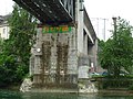
Building a bridge over the Limmat in the Second Battle of Zurich


Second World War
After the mobilization of 1./2. September 1939 a standby formation in the Swiss Plateau. In this initial configuration, the army units were grouped in such a way that in the event of an attack they could have made fronts in all directions immediately.
Limmatstellung as army position
On the basis of operational order No. 2 of October 4, 1939, the Swiss Army occupied the Limmat position in order to be able to stop an attack from the north and a bypassing of the Maginot Line through Switzerland. The divisions fortified and occupied the sections of the Limmat position from Gempenplateau to Sargans in the following order side by side (west-east): 2nd AK: Div 4 3 5, 3rd AK: Div 8 6, 4th AK: Div 7. The divisions 1 and 2 stayed in western Switzerland for the time being and the 9th division was in the central area. Over 360,000 combat troops were called in to expand and defend the Limmat position: 1st AK: 69,241 men, 2nd AK: 77,300, 3rd AK: 85,632, 4th AK: 93,500, Gempen division: 20,100, Murten division: 15,700 .
Since the Swiss could not have prevented a breakthrough of the Wehrmacht on the weakly occupied Swiss western border to France, Guisan reached a secret agreement with France ( Maneuver H ) that would have allowed French divisions to invade Switzerland and occupy the prepared artillery positions in Gempenplateau . The agreement was correct in terms of neutrality law , because there was no automatic mechanism and the French troops would only have been set off after a German attack and a request from the Federal Council for help.
On May 11, 1940 (the day before the Wehrmacht had started the campaign in the west ), the Federal Council ordered the second war mobilization : 450,000 men, 10,000 women from the voluntary FHD , 100,000 conscripts and just as many members of the local armed forces moved into active service a. The German successes in the western campaign and the collapse of France prompted General Henri Guisan at the beginning of June 1940 to extend the Limmat position from Basel to Geneva, which led to a thinly manned, linear all-round position of the army.
On June 23, 1940 - one day after the de facto surrender of France - Guisan gave the order to stop the fortification work in the previous positions. Only the last finishing work was to be carried out. The marches back from the Limmat position had already started in mid-June 1940.
Section boundaries (from west to east)

- City command Basel (Gempen Division, AK2) to Gempenplateau / Liestal ⊙
- 4th division AK2: Gempenplateau / Liestal to Stein ⊙
- 3rd Division AK2: Stein AG to Laufenburg ⊙
- 5th Division AK2: Laufenburg via Koblenz to the mouth of the Limmat (Lauffohr / Brugg) ⊙
- 8th Division AK3: Limmat estuary (Stilli) to Rüsler ⊙
- 1st division AK3: Rüsler to Urdorfer Senke ⊙
- 6. Division AK3: Urdorfer Senke to the city of Zurich ⊙
- City command Zurich AK3: City of Zurich to Bendlikon / Kilchberg ⊙
- 7. Division AK4: Bendlikon / Kilchberg to Sargans ⊙
Reduit
From June 25, 1940, Switzerland was surrounded on all sides by the Axis powers. Because the extended position on the Limmat, which had been made temporarily in the early summer of 1940, could not be maintained in the long term, General Guisan decided on July 10, 1940 to withdraw the bulk of the army to the Reduit national and to defend Switzerland in depth:
On July 12, 1940 he wrote to Federal Councilor Minger , head of the military department:
“I have made the following decision: The defense of the country will be organized according to a new principle, that of gradation in depth. For this purpose I have created three main resistance zones, which are supplemented by a system of support points in the gaps.
The three resistance tiers will be:
- the border troops, who maintain their current dispositive;
- an advanced or security position, which uses the current army position between Lake Zurich and the plateau of Gempen and is extended to the west by a front on the general line Berner and Neuchâtel Jura – Murten – Saane to the Bulle depression;
- an alpine or central position (réduit national), which is flanked in the east, west and south by the included fortifications of Sargans , St-Maurice and the Gotthard .
The missions assigned to these three resistance tiers are as follows:
- that of the border troops remains intact;
- the advanced or secured position blocks the axes of incidence into the interior of the country;
- hold the troops of the alpine or central position, provided with the largest possible supplies, without any thought of retreating (...) "
At the Rütli report on July 25, 1940, he announced the plan to concentrate the defense of Switzerland on the area of the High Alps with the important pass crossings, especially the Gotthard massif, in the event of an attack by the Axis powers, and to destroy all approaches to the mountains if necessary. Up to July / August 1940 six divisions (Div 1, 3, 6, 7, 8, 9) and three mountain brigades were in the Reduit, from May 1941 the remaining three divisions (Div 2, 4, 5) were added. With a general mobilization this corresponded to around 260,000 combat troops.
Limmat position as advanced position
The nine border brigades (90,000 men) remained in their border areas. The three light brigades (30,000 men), the territorial troops of the 13 territorial districts (90,000 infantry men), the local brigades (127,000 men) remained in the Swiss Plateau, where, in addition to the delayed battle, the demolition and destruction of the communication routes, Bridges, tunnels, storage and production facilities were commissioned as well as with the fight against airborne troops.
In spring 1944, the Limmat position was currently playing, because the General took into account that the army for political and military reasons could be forced to leave the central space of the redoubt to an opponent's kick through the Central Plateau to deny.
Cold War
The Limmat position was also of military importance during the Cold War . The Army Regulations "Command of the Army and the Large Units (FAG 83)" pointed out in the combat area chapter that, on the one hand, the expansion of road networks and motorways increasingly favors large-scale and rapid movements of mechanized units, and on the other hand, the fighting principles of modern armies are an obstacle Swiss terrain could only be used with restrictions. The implementation of this knowledge was based on the operation order and the basic disposition "Zeus" of April 28, 1989. The Limmat valley was such a challenge that this area was the only one on a detailed map with the title "Section of the section boundary FAK2 / FAK4 im Wettingen – Zurich area ”. The city of Zurich was assigned to Field Army Corps 4 , while the Limmat below Altstetten belonged to Field Army Corps 2 on both banks . According to the operational order of the Chief of Staff Eugen Lüthy (1986–1989), the former had to prevent an enemy collision with the Linth – Zürichsee – Limmat line, while the latter had to maintain the areas Limmat – Brugg – Lenzburg – Albis – west bank of the Zürichsee and Napf – Hauenstein . Due to the great armament efforts of the power blocs at that time, the army leadership assessed the threat situation as relatively real.
troops
As is usual in the Swiss Army, the troops consisted exclusively of militiamen whose civilian skills - for example in the construction of fortifications - were used accordingly. Since there was initially no wage adjustment, the troops set up welfare funds for troubled soldiers , which were mainly financed with the sale of soldiers' own brands .
With the operation order No. 2 of October 4, 1939 (deployment north), the general ordered the main forces of the army into the Limmat position from Sargans to the Gempenplateau south of Basel. The 3rd Army Corps under Colonel Corps Commander Rudolf Miescher occupied the middle section of the Limmat position from Lake Zurich from Bendlikon / Kilchberg to the Limmat estuary. The area of the city of Zurich on the left bank of the Limmat was largely assigned to the Zurich city command, then the Zurich 6th Division came to the Urdorf depression, the Welsche 1st Division to the Rüsler and the 8th Division from Central Switzerland to the Limmat estuary.
The border on the Rhine from Untersee to Kaiserstuhl had been occupied by Border Brigade 6 since August 29, 1939, and the section from Kaiserstuhl to Rekingen by Border Brigade 5 . They had to hold their positions with no retreat to the last cartridge.
In the delay area between the border brigades and the army position on the Limmat line, mobile units with cavalry , motorcyclists, cyclists and motorized units (the Light Brigade 2 behind the Thur and Töss , the 26th Infantry Regiment of the 6th Division behind the Glatt ) had the dragging fight Ensure that all mine objects are blown up and gradually withdraw behind the Limmat.
Since the army deployment at Front North was clearly directed against the German Reich, the general had the western border against France occupied by the 1st division in the Gros de Vaud and on the Mentue and with the 2nd division in the Neuchâtel Jura for reasons of neutrality . If the North case was triggered, however, the two French divisions would have been moved back to their combat areas in the Limmat position. The 1st division withdrawn from the Limmat position was replaced by the ad hoc association of the Dietikon group . This initially consisted of five to six territorial battalions, which were replaced at the beginning of December 1939 by the dropping out of the mountain infantry regiments 12 and 29 of the 9th Division.
Giving orders
The chain of command led from the general down to the lowest level, the platoon commanded by a lieutenant with around 50 men, divided into around 6-8 troops. The defense sections were hierarchically divided and assigned from the army corps to the individual troops. Each squad received a Ansichts kroki his section with plotted firebox. The squad could open fire on their own as soon as the enemy appeared in the assigned rooms. All troops had to hold the position entrusted to them until a withdrawal order was received.
Fortification construction on the Limmat line
On the basis of Operation Order No. 2, the general intended to build a bunker line - as already largely existing on the Rhine - directly on the Limmat. However, the planners of the 3rd Army Corps were able to convince the general to relocate the defensive front in a first phase to the wooded heights south of the Limmat, because a defensive position on the river would be dominated by the northern heights. Enemy cross-overs should primarily be smashed with artillery fire from the heights. If the opposing transition succeeded anyway, the next sustained resistance should take place on the line of the advanced bases Altstetten, Schlieren, Dietikon , Spreitenbach and Killwangen.
Since time was short and the troops built themselves and there were no uniform guidelines until mid-1940, they often built according to their own plans. The fortifications of the three divisions differed greatly. The 6th Division built many alternating positions for mobile combat and concrete shelters for the crew, but only a few concrete armaments. The 1st Division built the Dietikon Fortress and a linear front of trenches and barbed wire barriers on the front slope of the Heitersberg. The 8th Division's dispositiv was very static and had mostly concrete structures.
Until the capitulation of France on June 21, 1940, the fortifications had concentrated on the border zones, Sargans, Linth Plain, Limmat position, northern Jura with Hauenstein and St-Maurice . In addition to actual fortresses, the construction work also included infantry positions, gun positions, tank obstacles, command posts, military roads, accommodations, etc. Two days after France's surrender, Guisan issued the order to stop the fortification work, except for the final completion work in the previous positions.
Some of the 13,000 Polish internees from all over Switzerland who belonged to the 2nd Polish Rifle Division, which was forced into Switzerland in June 1940 after fighting against the Wehrmacht in France, were called in to complete the military road sections that had begun, the so-called Poland Paths .
Due to changed defense plans, the position of the Limmat was updated again in the spring of 1944. The Mutschellen axis, the Baden - Dättwil and Gibstorf - Birmenstorf axes as well as the existing mine objects on the Limmat were structurally reinforced.
City command Basel

Basel was to serve as an advanced fortified base. 526 barriers and positions were erected in the urban area. In an attack, house by house and street by street would have to be defended. The bridges over the Rhine and the lower Birs and other objects were prepared for destruction. The bridgeheads were greatly expanded on both sides and fortified with infantry bunkers. On April 20, 1940, the army command ordered a reinforced crew to secure the Basel section against raids and coups and to keep Basel on the line of resistance. In May 1940 the city command was subordinated to the Gempen Division , which was formed ad hoc . After the army withdrew to the Reduit, Basel was declared an open city .
Lock point Frick
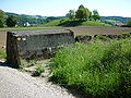
69 systems were built between the Gempenplateau and the Limmat estuary at Lauffohr for the Frick barrier. It formed the section of the 2nd Army Corps within the Limmat position. North of Frick, the Rheinfelden-Frick and Laufenburg-Frick axes were blocked from 1939 with an anti-tank obstacle and infantry bunkers. In 1984, the previous defensive position between Frickberg and Kornberg in connection with the new motorway was replaced with two Centurion bunkers and anti -tank obstacles.
In 1939/40 the heights of the Tafeljura in the Fricktal were provided with a chain of observation and armaments and simple buried troops. On the Altenberg near Wölflinswil , the 3rd Division built the Bächlimatte artillery position in the spring of 1940 . The three batteries with 7.5 cm field cannons 03/22 belonged to field artillery department 8, their field battery 22 had bunkered positions.
Lock Rein and Roost
The Rein-Roost barrier near Rein and Roost / Siggenthal formed the most important and longest dam - the fifth in the lower Aare valley - of the Limmat position. Between Geissberg and Iberig , the 5th and 8th divisions built a continuous tank obstacle in 1939/40 from Villiger-Buck (Geissberg) through Villigerfeld over the Aare to the foot of the Iflue (Iberig). The Aare between Brugg and Stilli formed the boundary between the two divisions. The total of 42 objects consisted of infantry flanking works, gun positions, artillery positions, the artillery works Besserstein and Rein and the artillery bunker Villiger-Buck. When the 5th Division moved into the Reduit in May 1941, the Border Brigade 5 took over their positions. After the Second World War, the lock was reinforced. In 1951, four former Vickers flab cannons were installed in bunkers for anti-tank purposes.

Lock Rein: Villigerfeld - Geissberg

Anti-tank bunker A 3829 Rein

Soldier memorial of Division 5 in Villigerfeld from 1940

Barrage Roost: The line of humps overgrown with bushes runs from the Aare through the valley to the foot of the Iflue / Iberig

Vickers-Flab / Pak Bunker Roost


Gibstorf - Gibstorfer Horn
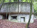
In the left section of the 8th Division, a 350 m long tank barrier was built at the foot of the Gibstorf Horn, which was supposed to block the narrow of Gibstorf . The dam site Gebenstorf was put under fire from 14 bunkers in the village Gebenstorf and on a Reussinsel distributed bunkers. The summit of the Gibstorfer Horn was used for artillery observation in the narrow Aare near the moated castle in Switzerland , on the axis of which 84 artillery pieces were concentrated.

Lattice tower for artillery observers, Gibstorfer Horn

Bunker in the moated castle in Switzerland

Bunker Bobbi : corner point of the trench system on the Horn, with a view to Waldshut


Baden - Dättwil
In the middle section of the 8th Division, the Baden – Dättwil axis had to be closed with the Baden-Dättwil barrier and an advance across the plateau of the Gibstorfer Horn had to be prevented. Tank barriers were built in the Meierhof and Allmend districts of Baden, and the Flueholz combat plant for infantry, artillery observation and battalion command post above the Kapperlerhof . Battalion 44 established a base in Dättwil.

Multi-purpose facility Flueholz , Kappelerhof Baden
Bunker for infantry cannon, machine gun and observer, Eichtal Baden
Bunker for two artillery observers with shelter, axis Baden – Dättwil

20 mm flab cannon to protect the Reuss Bridge Mellingen AG


Dättwil - Neuenhof
In the right section of the 8th Division, the Zurich Mountain Infantry Regiment 37 had to block the crossings from the Limmattal into the Reuss Valley between Baden and Oberrohrdorf ( Dättwil-Neuenhof blocking point ). On the front slope south of the Limmat, bunkered armaments for machine guns and infantry cannons as well as a continuous wire barrier were built. The drivable forest paths at the Neuenhof – Rüsler and Chlosterrüti – Dättwil crossings were provided with tank obstacles.

Machine gun bunker Stockrain, Neuenhof AG
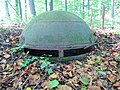
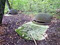
Steel dome of the Rüsler artillery observation post, Neuenhof AG

Spittelau bunker for two machine guns and a crew of 12, Dättwil AG

Spittelau bunker for infantry cannon, machine gun, observer and 18-man crew

Spittelau bunker for two machine guns

Entrance to the Spittelau concrete shelter


Dietikon - Birmensdorf
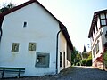
In the section of the 1st Division, which remained on the western border for reasons of neutrality, the center of Dietikon was expanded in 1939 with bunkers and a concrete ring wall of 300 × 150 m from the ad hoc formation Gruppe Dietikon into an important fortress of the northern defense line. Tank barriers, on which the weapons from around 24 bunkers were aimed, were used as outer locking positions. In 1940 it was inspected several times by General Guisan. The central school building served as a mobilization space. It was surrounded by defensive walls and bunkers. Soldiers were quartered, changing of the guard and main reading took place in the playground. Parts of the Dietiker fortifications have been preserved to this day - including a considerable piece of the former fortress wall in the middle of the city.

Dietikon Fortress 1939/40

Lindenbühl tank barrier, Dietikon Ost

three-story bunker Vogelau for two tank cans and five machine guns, Dietikon

Bergdietikon: Polenweg at Egelsee


Urdorf - Uetliberg
The three-kilometer-wide section of the 6th Division between Uetliberg, Sperrstelle Waldegg and Urdorfer Senke ( Sperrstelle Urdorf ) consisted of a deep system of changing positions that began on the Limmat and ended behind the Reppisch. There were no bunkered weapons positions, but troop shelters. Only through the open Urdorf depression ran a tank barrier with 18 concreted weapon stands.
At the Uetliberg there were over 100 bulletproof shelters and caverns that would have protected against enemy artillery use or air raids. The Uetliberg area was declared a military exclusion zone and kept secret. The defenders had to be able to fight through the protection of the shelters, as enemy infantry attacks were to be expected immediately after an artillery fire. The sapper company II / 6 of the 6th division under Captain Kollbrunner employed over 10,000 soldiers at times, who were on site day and night under the direction of a sapper soldier.
The barriers on the Waldegg delimited a target area for concentrated artillery use. 18 batteries in the Ringlikon, Birmensdorf, Stallikon and Oberlunkofen area were able to direct their fire into this cage, but also to work as far as Zurich, Wallisellen, Rümlang, Dielsdorf and the camps .

Panzergraben Uitikon-Waldegg

Small shelter "glasses" for Bat KP, 1940

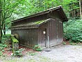
Sandstone cavern as crew accommodation, Buechhoger, Uitikon
Burmensdorf tank barrier


Zurich section
The Zurich section of the Limmat position was created under the direction of the 6th Division, the Zurich City Command, the Dietikon group and the Kyburg construction office. The city of Zurich was not declared an open city , but should be defended. For ten months they prepared to become the main line of action in a German attack.
In the advanced bases in Altstetten , Dietikon and Schlieren , as well as in Uitikon -Waldegg ( Uetliberg ) and the Urdorfer Senke, the city of Zurich and in Wollishofen ( Wollishofen-Sihltal barrier ), concrete weapon positions , bunkers , explosive objects and terrain armor obstacles were built from 1938 onwards according to the latest military criteria , In the wooded hills south of the Limmat, several artillery positions (gun positions, crew shelters) were dug . The reinforced bases for all-round defense, in Altstetten they were called Dachsleren, Kappeli and Panama , were built in the run-up to the city of Zurich to fight tanks.

Bunker at the port of Enge , City of Zurich

Bunker at the Quaibrücke , City of Zurich
The only surviving bunker in the city of Zurich, which was built according to the standard construction plans of the Bureau for Fortification Buildings (BBB)


In 1944, the rear positions were reinforced with tank barriers (bases in Birmensdorf , Rochade axis, Reppischtal ) and shelters ( Adliswil , Birmensdorf and Reppischtal).
Lining plain
The Lin plain was the target of mechanized units or airborne troops in almost all German operational planning because it enabled access to the Schwyz basin and towards the Gotthard. It therefore played an important role in the army's dispositive, first as part of the Limmat position and from July 1940 as part of the new central space position (reduit). The most important defensive positions were the Grynau and Benkner Büchel infantry fortress as well as the Linth dams to flood the Linth plain . To defend the access to the Reduitz in the Glarus region , the Näfels barrier was set up in 1941 .

Artillery observation tank turret A with five spherical slots
The Grynau Fortress defends the Linth crossing at Grynau Castle (machine gun bunker on the left)
Mösliflue infantry factory, Benkner Büchel

Infantry factory Burg, Reichenburg

Bunker along the Linth (towards Walensee), Benkner Büchel on the left


Artillery positions
The artillery positions belonging to the Limmat position were mainly in the Reuss valley , around the Birrfeld and in the Bruggerberg - Bözberg area . The gun posts in the main position were fixed with concrete or round timber-lined posts.
A unique artillery concentration of 84 guns was able to act on the alleged incursion axis in the narrow Aare near the water castle in Switzerland . Another concentrated artillery deployment was planned for the Waldegg lock point (Zurich), where 18 batteries with 72 tubes in mostly open field artillery positions in the Ringlikon (Brand) area, Birmensdorf (Haslen, Maas, Ramerenwald, Risi, Egg, Schüren, Löffler), Bonstetten ( Hörglen), Oberlunkhofen (Matteried) and Bremgarten (Hegnau) in a relaxed, checkerboard-like form and well camouflaged, were able to direct their fire into the “cage” of the Waldegg barrier.

Artillery observation bunker, Battery 134, Uetliberg

Oberrohrdorf Buacher: battery position with four gun positions. The 7.5 cm field cannon was driven into the cavern through the gate on the left.

Gun base for mobile 7.5 cm field cannon to prevent enemy cross-overs across the Limmat. Location Hegnau south of the Reuss near Bremgarten AG
Artillery Works Rein (A 3840) with Centi Bunker (A 3829)

Emergency exit AW Rein with bunker

Besserstein artillery plant, Geissberg

Geissberg Chameren artillery plant


Fortification construction in the delay area
The delay area north of the Limmat was only fortified at certain points. One example is the Regensberg base between Lägern and Glatt .
- Mg bunker A 5291 Regensberg cemetery ⊙

Machine gun and observation bunker A 5291 behind the historic city wall of Regensberg
Medieval and modern notches in Regensberg


Districts Bülach and Dielsdorf
In the Zürcher Unterland, three staggered defense belts were built from 1935 as part of the delay area of Unterländer not engaged in active service. At the same time, traffic routes were prepared for the blasting, such as the road and rail bridges in Eglisau . The first belt was located directly on the Rhine and consisted of numerous bunkers between Kaiserstuhl , Eglisau and the Tössegg . The second belt was created in the interior of the country at Siglistorf - Weiach - Glattfelden with bunkers, gun turrets and anti-tank traps, for example at the Seglingen barrier . The third belt at the height of Stadlerberg - Bülach and to the east of it belonged the barricade area Stadel with heavy artillery and anti-tank barriers and the medieval town of Regensberg with machine gun stands. Heavy artillery was stationed in the Baden and Dietikon area.
Assessment of the position on the Limmat by the Wehrmacht
A German deployment study from October 4, 1940 assessed the strength of the Limmat position as follows:
“ The Basel-Bodensee-Sargans defensive zone, opposite the old German border, is deeply structured in places and reinforced by a rear, second positioning system - cleverly based on the soil design and terrain obstacles. The spatial expansion is so large that it forces a frontal attacker to make a completely new deployment under difficult conditions after having overcome the first defensive zone. The upstream obstacles of the Aare, Limmat, Lake Zurich, Lake Walen up to the Upper Rhine Valley give this position system great natural strength, which has undoubtedly been increased by the expansion. "
Exhibitions
- The local history commission of the Aussersihl-Hard neighborhood association showed the exhibition Limmat Front - City at War. Exhibition on the position of the Limmat 1939–1940 in the building history archive of the city of Zurich in the building “zum lower Rech” on the Neumarkt in Zurich, from December 4, 2008 to April 3, 2009. Under the direction of the “City Command”, Zurich prepared for ten months to become the main battle line in a German attack.
- From 17 November 2018 to 28 February 2019 in the Museum Bellerive , the structural design of the Limmat position under the title "111 Bunker: Discover the hidden Zurich!" thematized. The city of Zurich was included in the first army position in 1939 as an "obstacle absolu", subordinated to the Zurich city command and fortified with the Uetliberg fortress to the left of the Limmat. At the same time, the Swiss National Exhibition 1939 took place around the lake basin , which was shaped by the national spiritual defense .
Associations for the fortifications of the Limmat position
- The Military History Society of the Canton of Zurich is today (2018) the owner of ten smaller and larger facilities on the Limmat position. The Limmat Fortress Works Association is responsible for the regular inspection and maintenance of these fortifications and conducts guided tours for groups on request.
- The Full-Reuenthal Military and Fortress Museum , founded in 1982, owns around 100 military and historical installations in the canton of Aargau. The historical military witnesses are preserved for posterity in the original or true to original condition and made accessible to the public.
- The bunker association Magden , founded in 2013, operates and maintains military-historical facilities as a contemporary document and promotes public interest.
literature
- Hans Senn : The Swiss General Staff, Volume VII, Beginnings of a Dissuasion Strategy during the Second World War . With a foreword by Kaspar Villiger . Verlag Helbing & Lichtenhahn, Basel 1995, ISBN 978-3-906419-58-9 .
- Walter Lüem et al .: The position of the Limmat in World War II , Baden-Verlag, Baden 1997, ISBN 3-85545-105-2 .
- Max Rudolf, Andreas Steigmeier : Guide to the Limmat position from the Second World War , Baden-Verlag, Baden 1998, ISBN 3-85545-114-1 .
- Walter Lüem, Max Rudolf: Defense in close-up. Problems of the Limmat defense in 1939/40 in the Spreitenbach-Killwangen section , Herrliberg / Birmenstorf 2003. Distribution: Swiss Society for Military History Study Tours GMS, Zurich.
- Military monuments in the canton of Zurich, inventory of combat and command structures . Edited by the Federal Department of Defense, Civil Protection and Sport , Bern, 2004.
- Local history commission of the Aussersihl-Hard neighborhood association: Military in the Sihl area , 2007.
- Markus Somm: General Guisan: Swiss-style resistance. On the 50th anniversary of death , Verlag Stämpfli AG, Bern 2010, ISBN 3-7272-1346-9 .
- Walter Schaufelberger: Zurich threatened. The history of the city command 1939/40 . Orell Füssli Verlag, Zurich 1990, ISBN 3-280-02026-3 .
- Robert Gubler: From the Zurich militia to the field division 1815–1991 . NZZ Verlag, Zurich 2003, ISBN 978-3-03823-062-5 .
- Memories of the war years 1939–1945. Christmas courier 1998, published by the municipality of Uitikon.
- Karl Schori: The Uetliberg defensive position in World War II . Swiss Society for Military History Study Trips, Wettingen April 2000.
Web links
- Limmat Front - City of Zurich in a state of war (PDF; 1.2 MB)
- Bunkers / shelters of the Limmat position in the Uetliberg / Urdorf area
- History of the Swiss fortification system ( Memento from December 3, 2012 in the Internet Archive )
- Military monuments in the canton of Zurich, inventory of combat and command structures (PDF; 2.9 MB)
- Limmat position
- The defense works of the city of Zurich The Zurich bunker hiking guide (download)
- Limmattalerzeitung from May 11, 2014: When Dietikon was still a fortress against Hitler's Germany
Individual evidence
- ↑ Ordre de Bataille for Operation Order No. 4 ( Memento of September 24, 2015 in the Internet Archive )
- ↑ Jürg Stüssi-Lauterburg : Free rock in brown surf. Speech on the 70th anniversary of the mobilization of war, Jegenstorf, September 2, 2009
- ↑ Management of the Armed Forces and Large Units (FAG 83) / Swiss Army, Bern EMD 1983, in force from January 1, 1984
- ↑ Walter Lüem, Max Rudolf: Defense in close-up. Problems of the Limmat defense in 1939/40 in the Spreitenbach-Killwangen section
- ^ Fortress Oberland: Sperrstelle Frick AG
- ↑ Inscription plaque at the tavern zur Krone, Dietikon: 1940 during the inspections of the Dietikon Fortress during World War II, General Guisan stayed as a guest at the Krone
- ^ Karl Schori: The defensive position Uetliberg in World War II . Swiss Society for Military History Study Trips, Wettingen April 2000
- ↑ Hans Senn: The Swiss General Staff. Volume VII: Beginnings of a Dissuasion Strategy during the Second World War
- ↑ SRF 1, Regional Journal Zurich of November 16, 2018: Hidden bunkers in Zurich - they're called Loch, Wurst or Schnapps
- ↑ NZZ of November 17, 2018: Off into the underground!
- ^ Military History Society of the Canton of Zurich: Annexes Limmatstellen
- ^ Bunker Association Magden
Coordinates: 47 ° 19 '20.4 " N , 8 ° 33' 1.2" E ; CH1903: 684,041 / 241868