
Urdorf lock point

The Urdorf locking point was a lock built by the Swiss Army between 1939 and 1940 during the Second World War to prevent the enemy from advancing into the Reuss Valley towards the Gotthard . The terrain tank obstacle (GPH) located in the municipality of Urdorf is of national importance as the most important blocking point of the Limmat position . The facilities are declassed , largely preserved and partially protected.
history
One month after the beginning of the Second World War , General Guisan ordered the deployment of the army from the standby position to the Limmat position on October 4, 1939, with "Operation Order No. 2". With the connection Sargans - Walensee - Zürichsee - Limmat - Bözberg - Hauenstein , it became the first line of defense of the Swiss Army in an attack from the north. This was fortified from September 27, 1939, including the Urdorf locking point.
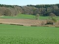
The three-kilometer-wide section of the 6th Division between Uetliberg , Waldegg and Urdorfer Senke consisted of a deep system of alternating positions that began on the Limmat and ended behind the Reppisch . There were no bunkered weapons positions, but fortified troop shelters. Only through the open Urdorf depression ran a tank barrier with 18 concreted weapon stands.
After the fall of France at the end of June 1940, the army command ordered the suspension of almost all fortification work, as the Limmat position lost its importance for the time being and the general had decided to withdraw the majority of the army into the Reduit .
During the Cold War , the lock was strengthened and modernized. It belonged to the operational area of Field Division 5 .
Terrain tank obstacle Urdorfer Senke
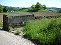
The project plan was drawn up in 1939/40 by the 6th Division based on the specifications of an engineer-officer course from 1938. An armored handrail obstacle (GPH) over two kilometers long with rail obstacles on the two valley flanks, which flank a tank ditch in the plain, was created across the Urdorf depression. The fortified valley flanks consisted of blocks with embedded rails, wide flange profiles and concrete tetrapods .
Urdorfer sink with obstacle, Mg bunker and Ik garage

Stockacherbach rail obstacle

Tank ditch

Chilstig concrete hump


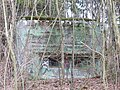
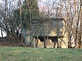
The obstacle could be taken under fire through numerous permanent weapon positions (bunkers). The defense line consisted of around 35 objects. Various troop units were involved in the construction of the tank ditch, the rail obstacles and the crew shelters. The machine gun stands, infantry cannon shields (Ik garages) and fortified observation posts were largely built by private contractors.
The bunker was armed with machine guns, only bunker A 5210 was additionally equipped with an anti-tank gun. The twelve bunkers were placed behind the obstacle and on both flanks. Concrete and covered infantry cannon shields for infantry cannons 35 (1935) with shelters were built behind the bunkers.
During the Cold War , parts of the armored terrain obstacle were demolished and replaced by modern angled retaining walls and rail obstacles. The shelters were supplemented with over 15 nuclear protection shelters (ASU).
Flanking bunker A 5221

Ik garage Mören
Wagenbach bunker A 5211

Flanking bunker Chilstig A 5207


Adjacent locking points
The Urdorf barrier bordered the Waldegg and Uetliberg barriers to the north and the Unter Reppischtal barrier and the upstream Oberurdorf base in the south .
Behind the Urdorf barrier was a second barrier in Birmensdorf with a 1.2 kilometer long obstacle and four bunkered infantry cannons. There were open field artillery positions that worked in the Urdorf, Schlieren and Albisrieden area (Waldegg lock) and could provide fire support.
These two lines were supplemented by additional road and forest path barricades in the Albisrieden, Ringlikon and Birmensdorf area. Dozens of shelters and observation bunkers were built in the forest between Schlieren and Albisrieden.

Oberurdorf base

Waldegg lock
Lock Birmensdorf

Artillery position in Birmensdorf


Objects still in existence

- "Fuchs" shelter A 4897 Bröggen, Schlieren ⊙
- "Himmel" shelter A 4898 Länxelmoos, Schlieren ⊙
- “Margrit” shelter A 4899 Schlatthölzli, Schlieren ⊙
- "Herdler Ost" shelter A 4900: 10 men ⊙
- "Ring" shelter A 4940: Kleibermättelistrasse ⊙
- Shelter «Murks» A 4941: Kleibermättelistrasse ⊙
- "Lichtung" shelter A 4942: house route ⊙
- Shelter "Rutsch" A 4943: house route ⊙
- "Cowslip" shelter A 4944: Forrenstrasse, Urdorf ⊙
- Schürhof observation post “Laura” A 4945: Bunker for two observers ⊙
- Bunker Ik-Kanone 4.7cm Unterreppischtal A 5199 Stigelmatt ⊙
- Bunker Ik-Kanone 4.7cm Unterreppischtal A 5200 Oberächer ⊙
- Unterreppischtal shelter A 5201 Reppischtalstrasse ⊙
- "Kragen" shelter A 5202 Kammstrasse ⊙
- Observation post «Kropf» A 5203 Kammstrasse, Eggweid ⊙
- Infantry bunker "Max" A 5204 Chilstig forest edge ⊙
- "Schaggi" infantry bunker A 5205 Flank Chilstig ⊙
- Ik sign «René» A 5206 Chilstig ⊙
- Infantry bunker «Moritz» A 5207 Flank Chilstig ⊙
- «Schang» infantry bunker A 5208, Chilstig flank ⊙
- Ik sign «Migg» A 5209 with garage Chilstig ⊙
- Infantry bunker with anti-tank gun "Tisliboll" A 5210 ⊙
- Infantry bunker A 5211 Wagenbach ⊙
- Infantry bunker A 5212 Mülihalden ⊙
- Ik sign «Hugo» A 5213 Zidacher, with garage Wagenbach ⊙
- "Glattler" infantry bunker A 5214 ⊙
- Ik sign «Bruno» A 5215 Wagenbach with Ik garage ⊙
- Ik sign «Bruno» A 5215 Wagenbach ⊙
- Infantry bunker Bad «Wirbel» A 5216 ⊙
- Farm «Mören» A 5217 ⊙
- Ik sign «Fritz» A 5218 Schüracher ⊙
- Ik sign «Fritz» A 5218 with Ik garage Schüracher ⊙
- Infantry bunker «Hegi» A 5219 ⊙
- Ik sign «Waldhof» A 5220 Hegiweg ⊙
- Ik sign «Waldhof» A 5220 Hegiweg with Ik garage 6648 ⊙
- Infantry bunker, flank forest «Hau» A 5221 ⊙
- Infantry bunker Buchholz A 5222 Rütiweid ⊙
- Atomic protection shelter ASU 31 F 20032 Allmendlistrasse ⊙
- ASU 32 F 20033 Allmendlistrasse ⊙
- ASU 33 F 20034 Bifigstrasse ⊙
- ASU 19 F 20035 Honertstrasse ⊙
- ASU 12 F 20052 Schürhof ⊙
- ASU 16 F 20055 Bröggen, Schlieren ⊙
- ASU 15 F 20056 Schlattwis, Schlieren ⊙
- ASU 14 F 20057 Schlierenstrasse, Schlierenwald ⊙
- ASU 27 F 20080 Chlosterholz ⊙
- ASU 28 F 20081 Langenboden ⊙
- Rail obstacle ⊙
- Terrain obstacle Stockacherbach ⊙
- Terrain obstacle Allmendbach ⊙
- Tank ditch ⊙
- Concrete hump Chilstig ⊙
literature
- Karl Schori: The Uetliberg defensive position in World War II . Swiss Society for Military History Study Trips, Wettingen April 2000.
- Rober Gubler: Field Division 6. From the Zurich Militia to the Field Division 1815–1991. NZZ Verlag, Zurich 2003, ISBN 3-85823-323-4 .
- Walter Lüem u. a .: The position of the Limmat in World War II , Baden-Verlag, Baden 1997, ISBN 3-85545-105-2 .
- Max Rudolf, Andreas Steigmeier : Guide to the Limmat position from the Second World War. Baden-Verlag, Baden 1998, ISBN 3-85545-114-1 .
Web links
Individual evidence
- ↑ Swiss website with documentation of Swiss and German operational planning: Limmatstellung 1940 ( Memento from September 24, 2015 in the Internet Archive )
- ↑ Military monuments in the canton of Zurich, inventory of combat and command structures, Bern 2004 (PDF; 2.9 MB)
Coordinates: 47 ° 22 '43.9 " N , 8 ° 26' 3.5" E ; CH1903: six hundred seventy-five thousand one hundred and ninety-two / 248037