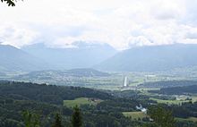
Benkner Büchel

The Benkner Büchel is an elevation with a maximum height of 605 m above sea level. M. It is in the area of the municipality of Benken in the Linth plain , to the right of the Linth Canal. Above is a scattered settlement that is connected to the village center by a road. One of the sights is the Maria-Bildstein.
The Benkner Büchel is a molasse hill , which was rounded off by glaciers from the Ice Age , a so-called round hump . It consists of a high-quality sandstone , which is one of the typical molasse stones. This rock was formed when a so-called molasse basin formed around 30 million years ago in the area of today's Benkner Büchel under the weight of the approaching Alps.
Maria Bildstein ("Gfrörer-Chappeli") is a place of pilgrimage and goes back to a wayside shrine built in 1519 . But it was not until the 18th and 19th centuries that pilgrims came to this place of pilgrimage in significant numbers . A chapel was built in 1848. A new building was erected between 1881 and 1883 and the present church in 1966.
Web links
Coordinates: 47 ° 11 ' N , 9 ° 1' E ; CH1903: seven hundred and nineteen thousand two hundred and seven / 226767

