
Schmerikon
| Schmerikon | |
|---|---|
 |
|
| State : |
|
| Canton : |
|
| Constituency : | Sea gaster |
| BFS no. : | 3338 |
| Postal code : | 8716 |
| UN / LOCODE : | CH SMK |
| Coordinates : | 714.46 thousand / 231615 |
| Height : | 408 m above sea level M. |
| Height range : | 404-550 m above sea level M. |
| Area : | 4.14 km² |
| Residents: | 3710 (December 31, 2018) |
| Population density : | 896 inhabitants per km² |
| Mayor : | Félix Brunschwiler (independent) |
| Website: | www.schmerikon.ch |
 Village center |
|
| Location of the municipality | |
  |
|
Schmerikon (in Swiss German “Schmerike” or “Schmärke”) is a political municipality in the constituency of See-Gaster in the canton of St. Gallen in Switzerland .
coat of arms
The coat of arms of Schmerikon shows two turned away golden crescents, raised by a white cross, on a red background. The oldest known depiction of a coat of arms dates from 1592 and showed a rose, flanked by two turned away crescent moons. The rose referred to the affiliation to the county of Uznach . Other early representations of the coat of arms can be found on a boundary stone near Grynau Castle (1656) and on the main portal of the St. Jodokus Church (1780). These also show the two crescent moons, but elevated by a cross. This could indicate the former affiliation to the Schänis monastery .
geography
Schmerikon is located on the slope of the Goldberg on the shores of Lake Zurich ( Obersee ), at the lower end of the Lin plateau at 408 m above sea level. M. Significant bodies of water within the municipality are the Aabach , Linth Canal and Lake Zurich. Schmerikon has an area of 5.98 km², a large part of which consists of forest (14.2%) and bodies of water (33.6%). The cultivated land and the reed areas make up 39.7%, the settlement area 3.2% of the municipal area.
On the shores of Lake Zurich and between the Aabach and Linth Canal there are large nature reserves.
population
Schmerikon has a permanent resident population of 3412 residents (as of 2012). The share of the foreign resident population is 23.7% (as of 2012).
Schmerikon is traditionally Catholic. Reformed people have also lived here since the 19th century. The waves of migration over the past fifty years have brought members of other Christian denominations as well as Islam, Buddhism and Hinduism into the community. The parish church of St. Jodokus belongs to the Catholic parish. The reformed parish operates a community center.
history


The area around Schmerikon had been around since the 8th century BC. Settled, as finds on the Balmenrain (and the field name Balm itself) suggest. In Roman times, Schmerikon was probably a station on the land or sea route from Zurich to Maienfeld . 600. AD. At the time of immigration of the Alemanni in the Linthebene was founded in Schmerikon. The old name "Smarinchova" means "Court of Smaro" or "Court of the Smaringers". He probably refers to an Alemannic clan.
Schmerikon was first mentioned in a document in 741 as part of a donation from the Alemannic nobleman Beata Landoald to the Lützelau monastery . In 744 Schmerikon came into the possession of the St. Gallen Monastery , in 1045 the Schänis Monastery . Since the 12th century there was a cooperative in Schmerikon , which as a corporation had land and fishing rights. This continues to this day as a community of comrades .
In the 13th century, the Counts of Toggenburg extended their rule over the area of the upper Lake Zurich. Schmerikon became part of the county of Uznach and the connection to Schänis Monastery was broken. After the Counts of Toggenburg died out, Schmerikon and the County of Uznach passed to the Lords of Raron . With the freedom letter of 1442 they confirmed the village a certain autonomy within the county of Uznach.
In the old Zurich war , Schmerikon was destroyed by the Zurich in 1444, although it had actually wanted a castle right with Zurich . As part of the county of Uznach, Schmerikon came under the joint rule of the two cantons of Glarus and Schwyz in 1449/1469 and thus became part of the Swiss Confederation . From 1400 to 1450 Schmerikon formed its own judicial district with Ammann within the county of Uznach. Then until 1798 one of the 7 days of the county.
In the Middle Ages and up to the early modern period, the village lived primarily from fishing, shipping, pilgrims to Einsiedeln , viticulture and the sandstone quarries . Since the silt of the Tuggenersee at the end of the early Middle Ages , Schmerikon has been at the upper end of the Zürichsee.
After the end of the old Confederation in 1798, Schmerikon first came to the canton of Linth and, after its dissolution in 1803, to the newly created canton of St. Gallen . Within the canton it was first part of the Uznach district , since 1831 of the lake district and since 2001 of the constituency See-Gaster .
The village of Schmerikon was repeatedly destroyed by major fires, such as in 1706 and 1865. In the 19th century, a mineral spring was discovered at the lake, which briefly earned the place the reputation of a spa. The construction of the railway line from Rapperswil to Weesen in 1859 destroyed the idyllic location on the lake. The large embankments and the rail traffic also meant the end of the Schmerikon port. At the end of the 19th century, the textile and machine industries in particular developed in Schmerikon. Its decline in the 1990s was largely offset by the establishment of new branches of industry. Nevertheless, an increasing number of the community's residents no longer work in Schmerikon, but in Rapperswil-Jona or in the greater Zurich area. Since the construction of the S-Bahn in the greater Zurich area and the completion of the Schmerikon bypass and the associated better connection to the national road network, the attractiveness of Schmerikon as a place of residence for commuters has increased significantly. This enabled Schmerikon to expand its population over the past ten years.
gallery

Site plan of Schmerikon on upper Lake Zurich around 1820

House zum Hirzen with village fountain in the center of Schmerikon

Catholic parish church of St. Jodokus
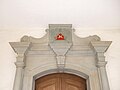
Portal of St. Jodokus with an old depiction of the municipal coat of arms (1780)

St. Jodokus, Gothic choir

View of the village and the Schmerkner Allmeind nature reserve from Goldberg

View of the village from the mouth of the Aabach

Kirchgasse
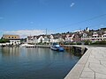
The old port


literature
- Bernhard Anderes: The art monuments of the canton of St. Gallen. Vol. IV. The lake district . (The art monuments of Switzerland). Birkhäuser Verlag: Basel 1966. pp. 518-538.
- Stefan Blarer-Ziegler: Melchior Blarer von Schmerikon (1729–1796): a humble priest of European stature . Ostermundigen: 1992.
- Albin Büsser: Schmerikon in words and pictures - then and now . Uznach 1913.
- Laurenz Kilger : History of the village Schmerikon . Schmerikon 1953.
- Alois Stadler / Hanspeter Keller: History of the community of Schmerikon . Tourist office Schmerikon: Schmerikon 2000.
Web links
- Official website of the community of Schmerikon
- Website of the local community Schmerikon
- Picture gallery of Schmerikon
- Alois Stadler: Schmerikon. In: Historical Lexicon of Switzerland .
Individual evidence
- ↑ Permanent and non-permanent resident population by year, canton, district, municipality, population type and gender (permanent resident population). In: bfs. admin.ch . Federal Statistical Office (FSO), August 31, 2019, accessed on December 22, 2019 .
- ↑ StiASG , Urk. Bremen 2. Online at e-chartae , accessed on June 12, 2020.
Amden | Benken | Eschenbach | Gommiswald | Kaltbrunn | Rapperswil-Jona | Schänis | Schmerikon | Uznach | Weesen
Former communities: Ernetschwil | Goldingen | Jonah | Rapperswil | Vineyards | St. Gallenkappel
Canton of St. Gallen | Constituencies of the Canton of St. Gallen | Municipalities of the Canton of St. Gallen