
Amden
| Amden | |
|---|---|
 |
|
| State : |
|
| Canton : |
|
| Constituency : | Sea gaster |
| BFS no. : | 3311 |
| Postal code : | 8873 |
| Coordinates : | 729 100 / 223400 |
| Height : | 903 m above sea level M. |
| Height range : | 419–2101 m above sea level M. |
| Area : | 43.02 km² |
| Residents: | 1784 (December 31, 2018) |
| Population density : | 41 inhabitants per km² |
| Website: | www.gemeinde-amden.ch |
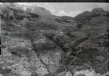
 The Amden terrace above the Walensee |
|
| Location of the municipality | |
  |
|


Amden (in local dialect Amde [ ˈɑ̝mdə ]) is a village and a political municipality in the Swiss canton of St. Gallen .
geography
With an area of 43 km², Amden is one of the larger municipalities in the canton. 12.09 km² are forest. The highest point in Amden is at 2101 m above sea level. M. on the Leistchamm , the lowest point 421 m at the Walensee .
The municipality of Amden consists of four parts: Dorf (900 m above sea level), Arvenbüel (spoken with - / f / - , 1250 m above sea level), and on the banks of the Walensee Fli or Fly (430 m above sea level) .) and Betlis (430 m above sea level) with the parts of Upper and Lower Betlis .
population
The total number of inhabitants in the four parts was 1612 in 2008, of which 1314 in the village and Arvenbüel, 270 in Fli and 28 in Betlis. Of these, 659 were local citizens, 1035 were Catholic and 313 were Protestant. The residents of Amden are called Ammler .
Economy and Infrastructure
There are jobs in the areas of agriculture, hospitality and construction, and in various areas of service.
traffic
In 1882 the road to Weesen was opened. Ten years later, a stagecoach ran twice a day until the local community took over the transport operation in 1918. She bought two old army trucks and converted them into seventeen-seat buses. The Weesen – Amden car company was founded. The company, which made a significant contribution to the development of the resort, brought work and earnings to the community. In 1950 the garage and workshop was built. Today the company has 14 vehicles, in addition to the course operation (around 200,000 passengers per year), it organizes excursions, operates a truck and taxi company and clears snow in winter.
history
Prehistory and early history
The first inhabitants settled in the Churfirsten area 50,000 years ago, probably only temporarily. Among other things, they settled the Wildenmannlisloch in the upper Toggenburg. However, the settlement of Amden by the Raetians in the time before the birth of Christ is unclear . What is only known is that they settled the region from Lake Walen to the Glarnerland .
1st century BC BC to 5th century
A settlement in Amden by the Rhaeto-Romans cannot be proven with certainty, there are only indications. Field names can be derived from Rhaeto-Romanic words, for example: Furggeln (furca, the fork), Tschingel (cingulum, protruding rock band) or Gulmen (cuolm, the mountain).
Evidence of Roman settlement can be found in the Strahlegg castle ruins in Betlis, which were built in the 1st century BC. Was created for military purposes.
6th to 12th century
After the fall of the Roman Empire, the lords changed in quick succession. After the Ostrogoths , Franks and Swabians , Amden and the Walensee area came to the Lenzburg and the county of Kyburg. The Schänis Monastery also acquired large areas. Amden is mentioned for the first time in a bull from 1178, which is received in a later copy, in which the Pope confirms the possessions of the monastery in Andimo monte .
13th to 18th centuries
When the Toggenburgers came into possession of the land on the Walensee, a dispute broke out between the Zurich, the Schwyz and Glarnern. Zurich would have liked to claim the important transit area for itself, with Glarus and Schwyz seeing the rights on their side.
In 1438 the entire Gaster district was pledged to Glarus and Schwyz for 3,000 guilders. The pledge was never redeemed and so Amden remained subject to the Confederates until 1798 .
1798-1910
The French Revolution meant dismissal from the subject relationship. Amden was first assigned to the canton of Linth , then to the canton of Glarus and finally in 1815 to the canton of St. Gallen.
In 1817 a great famine in Amden led to a sharp decrease in the population because many people emigrated. In 1829 the Hofstetten settlement burned down and in 1874 another fire destroyed the village of Unterbach. In 1908 the weaving factory was built in Sittli. As a result of silk weaving, which emerged from the middle of the 19th century, around 300 women were given jobs.
Amden landslide
Since 1972 a tilting movement of the Schrattenkalk , the uppermost rock mass, has been observed in the Schwarzberg-Schafbett area . It was estimated at ½ million cubic meters and threatened to crash over the Weesen – Amden road into the Walensee. The initial sliding speed of 5 cm per month increased noticeably. Bulky newspaper reports gave the impression that the village itself was in danger. Pedestrian traffic was reduced to a minimum, hotels, guest houses and the lift company had to accept financial losses.
In autumn 1973, with the help of the military (Sap Kp II / 8 and Sap Kp I / 35), an emergency road to Toggenburg was built within a very short time. An Amden – Nesslau road project from 1906 was used for this, the implementation of which would have cost CHF 710,000 and was therefore not implemented. However, the emergency road could not be used the following winter due to the risk of avalanches. Since the Schwarzberg tilted threateningly, the loose rock masses began to be observed around the clock and illuminated with spotlights at night.
In mid-January 1974 the road was closed. Helicopters from the army, Rega and Heliswiss took care of the community. On foggy days, when flight operations had to be suspended, it was deserted in Amden. On the night of January 21, 1974, a large part of the rock mass (around 50,000 m³) came loose and fell into the quarry. The road was only slightly damaged. Days later, the parties that were still in danger of falling were blown off (40,000 m³). The road was opened to traffic again in mid-February. In 1981 the rockfall galleries were built to secure the Weesen – Amden road.
Sightseeing and tourism
Architectural monuments
The Strahlegg castle ruins stand on the banks of Lake Walen in Hinterbetlis. They are the ruins of a Roman watchtower that was converted into a castle in the Middle Ages. The building is under federal monument protection.
The parish has three churches. The Catholic parish church of St. Gallus can be traced back to the 13th century, but was rebuilt in the 20th century. The Catholic St. Anna chapel and the Protestant mountain church were rebuilt in the 1970s.
tourism
In addition to a local museum, Amden offers a natural ice rink, a ski area, hiking trails, tennis courts, opportunities for canyoning and climbing as well as water sports in the indoor pool and at Lake Walen.
The most famous mountains in the area of the municipality of Amden are Leistchamm , Flügenspitz , Gulmen , Mattstock , Speer , Chapf and Durschlegi . Below the village of Amden is the Seerenbachfall , consisting of three waterfalls with a total height of 585 m, the highest waterfall in Switzerland. Right at its foot is the Rin spring , a river spring from an underground cave system. There are also various raised bog areas in the municipality .
The 87-kilometer Toggenburger Höhenweg runs through Arvenbüel and leads in five stages from Wildhaus via Atzmännig and Mühlrüti to Wil .
Personalities
- Otto Meyer-Amden (1885–1933), artist
- Hermann Huber (1888–1967), painter, fresco artist, draftsman, etcher and lithographer, lived in Grächen 1912–1913
- Doris Stauffer (1934–2017), artist and feminist
- Michael von der Heide (* 1971), singer
Web links
- Website of the municipality of Amden
- Silvio Bucher: Amden. In: Historical Lexicon of Switzerland .
Individual evidence
- ↑ Permanent and non-permanent resident population by year, canton, district, municipality, population type and gender (permanent resident population). In: bfs. admin.ch . Federal Statistical Office (FSO), August 31, 2019, accessed on December 22, 2019 .
- ↑ Philipp Obrist / Andres Kristol: Altstätten SG (Upper Rhine Valley) in: Dictionnaire toponymique des communes suisses - Lexicon of Swiss community names - Dizionario toponomastico dei comuni svizzeri (DTS | LSG). Center de dialectologie, Université de Neuchâtel, Verlag Huber, Frauenfeld / Stuttgart / Vienna 2005, ISBN 3-7193-1308-5 and Éditions Payot, Lausanne 2005, ISBN 2-601-03336-3 , p. 87. Specified phonetic transcription : [ ˈamdə ]
- ↑ Amden at ortsnames.ch . The phonetic transcription used : ą́mdə .
Amden | Benken | Eschenbach | Gommiswald | Kaltbrunn | Rapperswil-Jona | Schänis | Schmerikon | Uznach | Weesen
Former communities: Ernetschwil | Goldingen | Jonah | Rapperswil | Vineyards | St. Gallenkappel
Canton of St. Gallen | Constituencies of the Canton of St. Gallen | Municipalities of the Canton of St. Gallen