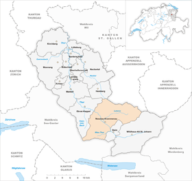
Nesslau-Krummenau
| Nesslau-Krummenau | ||
|---|---|---|
| State : |
|
|
| Canton : |
|
|
| Constituency : | Toggenburg | |
| Political community : | Nesslau | |
| Postal code : | 9643 Krummenau 9650 Dicken (Nesslau) |
|
| former BFS no. : | 3358 | |
| UN / LOCODE : | CH NES (Nesslau) | |
| Coordinates : | 733 391 / 231949 | |
| Height : | 759 m above sea level M. | |
| Area : | 80.63 km² | |
| Residents: | 3296 (December 31, 2012) | |
| Population density : | 41 inhabitants per km² | |
| Website: | www.nesslau.ch | |
| map | ||
|
|
||
Nesslau-Krummenau was a political municipality in the Swiss canton of St. Gallen from 2005 to 2012 . After the merger with Stein (SG) , decided on January 1, 2013, it was merged into the new municipality of Nesslau .
Structure, area, inhabitants, coat of arms
Nesslau-Krummenau in upper Toggenburg emerged on January 1, 2005 from the municipality of Nesslau (zip code 9650) and the municipality of Krummenau. It consisted of the villages Krummenau (zip code 9643), Neu St. Johann (zip code 9652) and Ennetbühl (zip code 9651).
With 80.63 km², Nesslau-Krummenau was the third largest municipality in the entire canton of St. Gallen. On December 31, 2004 Nesslau had an area of 38.18 km² and a population of 1,965, while Krummenau had an area of 42.28 km² and 1,493 inhabitants. The entire political community of Nesslau-Krummenau had 3,348 inhabitants at the end of 2010.
The coat of arms showed two silver wavy bars on a blue background (for the rivers Thur and Luteren) as well as two gold stars that represented the two former communities.
geography
The villages of Nesslau-Neu St. Johann and Krummenau are located in the upper Thurtal and Ennetbühl in the Luterental on the Schwägalp pass road. Part of the highest Nagelfluh mountain in Europe, the Speer (1950 m), and part of the Alpstein belonged to the municipality of Nesslau-Krummenau . The municipality extends east to the top of the Schwägalp pass, which forms the border with the canton of Appenzell Ausserrhoden . The highest mountain in the municipality is the Silberplatten in Alpstein near Säntis at 2158 m . The Thur and the Luteren flow through the municipality . The two rivers are shown in the coat of arms as two silver wavy bars. Near the village of Krummenau is the valley station of the Wolzenalp-Bahnen, which lead to Wolzenalp in Nesslau and open up the ski and hiking area of the same name. The area is accessed by the railway line of the Südostbahn from Wattwil with the stations in Krummenau and Nesslau-Neu St. Johann. From Nesslau the Postbus lines lead to Wildhaus - Buchs SG and via Schwägalp to Urnäsch AR.
history
From the 12th century the area was colonized by the Counts of Toggenburg and the Prince Abbey of St. Gallen . The first documented mentions of a Nesselove farm and a Crummenouve estate come from the 13th century . In the 16th century the market town of Sidwald began to develop as an important cattle and goods market. After a fire in the St. Johann monastery in today's Alt St. Johann , the construction of a new monastery complex near Sidwald began in 1626, which is how it was named Neu St. Johann . In the course of the secularization of the prince abbey of St. Gallen, the monastery became a parish and parts of the complex were later set up as the Johanneum curative education center .
The Reformation was introduced in Krummenau in 1524 and in Nesslau in 1528 , with the church remaining on an equal footing until the Catholic parish of Neu St. Johann was founded in 1806 . After the founding of the Canton of St. Gallen in 1803, the political communities Krummenau and Nesslau were founded. Nesslau was the capital of the Obertoggenburg district from 1831 to 2002 .
In the middle of the 19th century, Yenish families were naturalized in Neu St. Johann due to the law to combat homelessness .
In addition to agriculture, which is still important today, the Rietbad sulfur spring near Ennetbühl was already known in the Middle Ages and a modest spa tourism emerged. In 1857 the brothers Emil and Gustav Gnipper founded a textile company in Neu St. Johann, which was later taken over by the Meyer-Mayor family. In addition, the embroidery industry flourished until the First World War.
In 1912 the Bodensee-Toggenburg Railway completed the railway line from Ebnat-Kappel to Krummenau and Nesslau-Neu St. Johann . In 1919 Postbuses replaced the horse mail from Nesslau to Wildhaus. The Nesslau-Neu St. Johann terminus thus became an important transshipment point for goods and people and tourism in Obertoggenburg experienced an upswing. Various projects to continue the train via Wildhaus to Buchs or as a cogwheel train over Unterwasser to the Säntis summit, however, failed.
In 1947, a village fire broke out in the neighboring municipality of Stein , and houses in the former municipality of Nesslau also burned.
After the population of both communities had clearly agreed, the political communities Nesslau and Krummenau were merged on January 1, 2005 to form the community Nesslau-Krummenau . A merger with the town of Stein led to the new municipality of Nesslau on January 1, 2013 .
Tourism and sightseeing
The 60 kilometer long Thurweg , a hiking trail that runs along the Thur from Wil to Wildhaus , runs through the former municipality .
Personalities
See Nesslau .
literature
- Hans Büchler: Krummenau. In: Historical Lexicon of Switzerland .
- Hans Büchler: Nesslau. In: Historical Lexicon of Switzerland .
- H. Büchler, The Toggenburg in old views from the 17th to the 19th century, 1975.
- W. Vogler, The St. Johann monastery in the Thurtal, 1985.


