
Mogelsberg
| Mogelsberg | ||
|---|---|---|
 |
||
| State : |
|
|
| Canton : |
|
|
| Constituency : | Toggenburg | |
| Political community : | Neckertal | |
| Postal code : | 9113 Degersheim (Wol- fensberg, Mämetschwil , Wolfhag) 9114 Hoffeld 9115 Dicken 9116 Wolfertswil (Moos) 9122 Mogelsberg 9122 Ebersol 9123 Nassen 9125 Brunnadern 9126 Necker |
|
| former BFS no. : | 3406 | |
| Coordinates : | 728 196 / 247110 | |
| Height : | 755 m above sea level M. | |
| Area : | 32.96 km² | |
| Residents: | 2203 (December 31, 2007) | |
| Population density : | 67 inhabitants per km² | |
| Website: | www.mogelsberg.ch | |
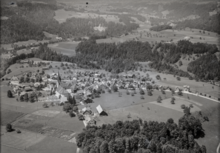
 Mogelsberg (1980) |
||
| map | ||
|
||

Mogelsberg , Swiss German Mogelsberg or Mogelschberg , is a village and a former political municipality in the district of Untertoggenburg and since 2003 in the constituency of Toggenburg in the canton of St. Gallen in Switzerland . Since 2009 Mogelsberg has formed the Neckertal community together with Brunnadern and St. Peterzell . Around 830 inhabitants live in the village center and the surrounding new development areas.
geography

Mogelsberg is located in the Neckertal above the Necker river . The village of Mogelsberg lies at an altitude of 755 m above sea level. M. and is bypassed in a loop by the St. Gallen – Wattwil line of the Südostbahn . The lowest point in the community was on the Necker River at 600 m above sea level. M., the highest point on the Wilkethöhe at 1175 m above sea level. M.
The communities Mogelsberg included the localities Mogelsberg, Dicken - with part of Dicken being in the St. Peterzeller municipality - Necker , Nassen , Hoffeld and Ebersol , the settlements Dieselbach, Hofstetten, Furt and Wolfensberg as well as other hamlets and individual farms. Wolfensberg is not far from Degersheim and is mainly oriented there. For St. Gallen standards, Mogelsberg had an above-average parish area, criss-crossed by valleys, and had a road network of over 200 kilometers. The community had eight postcodes and several primary schools .
The neighboring communities of Mogelsberg were Degersheim , Schwellbrunn , St. Peterzell , Hemberg , Brunnadern , Oberhelfenschwil , Ganterschwil and Lütisburg .
history


Mogelsberg was first mentioned in 1152 under the name Magoldesberch . The place name is derived from an elevation of the terrain by a person named Magold.
The landowners were the abbeys of St. Gallen , Magdenau and above all St. Johann . The lords of Mogelsberg mentioned in 1242, ministers of the Toggenburg and St. Gallen monastery, later moved away. St. Johann had the right of patronage to the church, mentioned in 1275 and originally consecrated to St. Nicholas. The Counts of Toggenburg, who considered Mogelsberg as their own in the 14th century, ousted the St. Johann Abbey. After the male line of the Toggenburg family had expired in 1436, one of the heirs, Hildebrand von Raron , was buried in Mogelsberg in 1459. Mogelsberg formed a lower court with surrounding places . The northeastern courtyards, u. a. Dieselbach belonged to the Magdenau court. 1468 Mogelsberg came as part of the bailiwick Toggenburg at the Abbey of St. Gall. In the 17th century the plague raged in the village several times. From 1798 to 1803 Mogelsberg belonged to the Säntis canton .
A document from 1178 speaks of the mother church in Mogelsberg . In 1528 almost the entire Mogelsberg population converted to the Protestant faith in the course of the Reformation movement . After the Reformation, only Reformed services were held until 1567. The parity church since 1567 gave way to a new building in 1810, which was renovated in 1932 and 1992. In 2000, 52% of the population were Reformed and 32% Catholic. The two denominations live a strong ecumenical movement and administer the St. James Church equally .
In 1224 there is said to have been a spa in Ebersol. In agriculture, grain cultivation prevailed, with mills on the Aach, near Hoffeld and Furth. From the 18th century cotton was processed in the houses. Around 1850 embroidery factories were established in Necker, Furth and Dicken; In 1890 the community had around 450 embroidery machines. At the same time, livestock and dairy farming displaced agriculture. After 1810 the construction of a road network began. In 1910 the “Loan Fund” was founded, today's Raiffeisenbank . In the same year, the Bodensee-Toggenburg Railway (BT) traveled from St. Gallen to Wattwil for the first time . With the connection to the railway, Mogelsberg developed into a hiking and climatic health resort. After 1918, medium-sized businesses took the place of the textile industry. The secondary school in Necker , built in 1865, has been run with neighboring communities since 1920. After the Second World War, tourism fell sharply. With the construction of a sports and holiday center in 1984, Mogelsberg tried to revive tourism. However, it was not successful and the resort hotel with the sports center had to be closed in 2009.
Mogelsberg was an independent political municipality until December 31, 2008. In the vote on October 21, 2007, the residents of Mogelsberg voted for a merger with Brunnadern and St. Peterzell to form the new Neckertal municipality on January 1, 2009.
population
| year | 1831 | 1850 | 1888 | 1900 | 1941 | 1950 | 1980 | 2000 |
| Residents | 2669 | 2841 | 3097 | 2777 | 2315 | 2485 | 1809 | 2261 |
Attractions

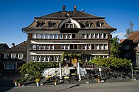
The parity church St. Jakobus, the Gasthaus Rössli, the wooden bridge Anzenwil and the house Näf are listed in the list of cultural assets in Neckertal . Mogelsberg is listed in the inventory of places worth protecting in Switzerland .
The parity church built in 1810 in the center of the village belongs to the type of late baroque preaching hall with a sober room envelope. The renovation in 1992 brought a lot of light into the church. The choir has a high altar and two side altars.
The Gasthaus Rössli , built by Johann Jakob Haltiner and located next to the church, is a knitted building from the 18th century with a mansard roof and a curved transverse gable.
In the hamlet of Hofstetten there is a group of knitted structures from the 17th century.
The Neckertal treetop path, opened in 2018, leads over 500 meters through the treetops of a diverse forest. The number of visitors exceeded all expectations.

Parity Church
Gasthaus Rössli

Treetop Walk

Anzenwil wooden bridge


Economy and Transport

In 2001 Mogelsberg had around 110 farms and 100 smaller businesses.
Mogelsberg has a train station on the St. Gallen – Wattwil line of the Swiss Southeast Railway . The operation by the S2 and S4 of the train St. Gallen gives a half hour . Road connections exist to Degersheim , Necker and Ebersol .
Sons and daughters of the church
- Philipp Müller (* 1952), politician (FDP)
Web links
Individual evidence
- ↑ a b Mogelsberg on ortsnames.ch (online database), accessed on June 20, 2020
- ↑ Mogelsberg, on the website of the municipality of Neckertal, accessed on June 19, 2020
-
↑ a b c d e f g Beat Bühler: Mogelsberg. In: Historical Lexicon of Switzerland .
These sections are largely based on the entry in the Historical Lexicon of Switzerland (HLS), which, according to the HLS's usage information, is under the Creative Commons license - Attribution - Distribution under the same conditions 4.0 International (CC BY-SA 4.0). - ↑ a b c d Mogelsberg community (Hrsg.): Mogelsberg - A work on the past and present. Mogelsberg 1999.
- ↑ a b c Mogelsberg church district. On the website of the Evangelical Reformed parish Unteres Neckertal, accessed on June 19, 2020
- ↑ Ebersol. On the website of the municipality of Neckertal, accessed on June 14, 2020
- ↑ Neckertal treetop path. On: meintoggenburg.ch by Martin Lendi, accessed on June 19, 2020
- ↑ 870 Romanshorn - St. Gallen - Wattwil - Rapperswil. In: Official course book , timetable year 2020
Bütschwil-Ganterschwil | Ebnat-Kappel | Hemberg | Kirchberg | Lichtensteig | Luetisburg | Mosnang | Neckertal | Nesslau | Oberhelfenschwil | Wattwil | Wildhaus-Alt St. Johann
Former parishes: Alt St. Johann | Well veins | Bütschwil | Ebnat | Ganterschwil | Kappel | Krinau | Krummenau | Mogelsberg | Nesslau | Nesslau-Krummenau | St. Peterzell | Stone | Wildhaus
Canton of St. Gallen | Constituencies of the Canton of St. Gallen | Municipalities of the Canton of St. Gallen