
Oberhelfenschwil
| Oberhelfenschwil | |
|---|---|
 |
|
| State : |
|
| Canton : |
|
| Constituency : | Toggenburg |
| BFS no. : | 3375 |
| Postal code : | 9621 |
| Coordinates : | 726 494 / 246149 |
| Height : | 798 m above sea level M. |
| Height range : | 576–1102 m above sea level M. |
| Area : | 12.65 km² |
| Residents: | 1261 (December 31, 2018) |
| Population density : | Error in expression: Unrecognized word "xxxxx" inh . Per km² |
| Website: | www.oberhelfenschwil.ch |
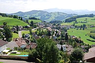
_168.JPG) Oberhelfenschwil |
|
| Location of the municipality | |
  |
|
Oberhelfenschwil is a municipality in the canton of St. Gallen in Switzerland . It is located in the Toggenburg constituency .
Oberhelfenschwil has 1261 inhabitants and is therefore the sixth smallest municipality in Toggenburg . The municipalities of Oberhelfenschwil, Neckertal and Hemberg plan to merge into a single municipality on January 1, 2023 .
geography

The village is on a hill between the Thur and Necker rivers . The highest point is at 1100 m above sea level. M. the Köbelisberg-Waldschwilerberg, on the border with the municipality of Wattwil . The lowest point is at 580 m above sea level. M. on the banks of the Thur near Dietfurt ("Thurrank"). Oberhelfenschwil is located 13 kilometers southeast of Wil SG , 6 km northeast of Wattwil and 7 km southwest of Degersheim SG (in each case air lines). Part of the village of Necker , the Wasserfluh and the scattered hamlets of Wigetshof, Oberwil, Metzwil, Rennen, Winzlisau, Utenwil, Schwanden and Füberg belong to Oberhelfenschwil.
The total area is 1265 hectares . Of this, 5.1 percent is settlement area and 59.8 percent is agricultural area. 34.0 of the area are forest and woody plants and 1.1 percent are unproductive areas (2009).
The neighboring communities are Ganterschwil in the north, Neckertal in the east, Wattwil in the south, Lichtensteig in the southeast and Bütschwil in the west. Although the name suggests it, Niederhelfenschwil is not in the neighborhood, but 23 kilometers northeast of Oberhelfenschwil.
history
_191.JPG)

The municipality was settled by Alemanni early on along the ridge . Oberhelfenschwil was mentioned in a document in 882 as Helfoltiswilare and in 1515 as Oberhelfenschwil . The prince abbey of St. Gallen , the Counts of Toggenburg and the Alt St. Johann monastery owned land in Oberhelfenschwil. The count's goods fell in 1468, the remaining in 1555 to the prince abbey of St. Gallen and Oberhelfenschwil were assigned to the Neckertal court. Füberg Castle was located in the municipality, which is only reminiscent of the field name today. The castle Rüdberg an der Thur near Laufen and the Neu-Toggenburg above the pass road Wasserfluh , mentioned in 1270, have both fallen to ruins. The Helvetic Constitution allocated the municipality of Krinau to Oberhelfenschwil in 1798 , and in 1803 the two localities were separated again and the political municipalities of Oberhelfenschwil and Krinau were formed. In 1874 Oberhelfenschwil ceded the St. Loretto, Hof and Blatten areas to Lichtensteig . In 1952 Mogelsberg and Oberhelfenschwil agreed to an exchange of territory. Oberhelfenschwil got the hamlet of Rennen and the farms of Adelbach, Berg and Schlatt (46 inhabitants) from Mogelsberg, during which Mogelsberg got the former Oberhelfenschwiler exclave Hiltisau with 38 inhabitants. In 1874 Oberhelfenschwil ceded the St. Loretto, Hof and Blatten areas to Lichtensteig . From 1831 to 2002 Oberhelfenschwil belonged to the Neutoggenburg district .
In the church of St. Maria, Dionys and Jakobus mentioned in 1336, a Reformed church service was held from 1528, and since 1534 it has been used equally .
The main feature of the economic structure of the mountain resort with little fog is the balance between agriculture and forestry, tourism (camping, skiing), trade, services (care and spa center) and small industry (especially construction and metal industry). A covered wooden bridge has been crossing the Necker near Aachsäge since 1849. In 2005 Oberhelfenschwil, Brunnadern , Mogelsberg and part of Ganterschwil merged to form the Neckertal school community .
coat of arms
The coat of arms is split from gold and silver. Heraldically to the right is a three-part tower in black . Left six times horizontally divided by silver and black.
population
| year | 1827 | 1850 | 1900 | 1950 | 2000 | 2010 | 2018 |
| Residents | 1196 | 1872 | 1079 | 982 | 1456 | 1341 | 1261 |
| source | |||||||
On December 31, 2012, 1,325 people were living in Oberhelfenschwil. The proportion of foreigners was 8.3% in 2008 and is thus well below the cantonal average of 21.5%. About a quarter of the foreign population were citizens of Germany . Behind them were citizens of one of the states of the former Yugoslavia and Italians .
Politics and law

The legislative power in Oberhelfenschwil is the citizens' assembly . It usually takes place once a year, usually at the end of March.
The executing authority is the municipal council . His term of office is four years. It is elected by the people in a majority procedure. He leads and represents the church . To this end, it implements the resolutions of the citizens' assembly and the tasks assigned to it by the canton and the federal government. As head of the executive practicing Mayor on business in the whole office, the remaining councilors from in the next office. The community council consists of 7 people and is supported by the community clerk.
The District Court of Toggenburg, based in Lichtensteig, is responsible for legal disputes . Oberhelfenschwil also has a mediator ( justice of the peace ).
traffic

Oberhelfenschwil can be reached from Necker , Dietfurt and Ganterschwil on public roads. A post bus connects Oberhelfenschwil every hour with the Dietfurt train stations on the Wattwil – Wil and Brunnadern-Neckertal lines on the Wattwil – St. Gallen .
economy
The largest employers in Oberhelfenschwil are Karl Egli carpentry and Mock AG Tiefbau.
Oberhelfenschwil has a small ski lift that is mainly used by locals. The valley station is located on Berligstrasse. The ski lift leads over a length of around 330 meters up the southern slope via Altegg in the direction of Grund.
The main feature of the economic structure of the mountain resort with little fog is the balance between agriculture and forestry, tourism (camping, skiing), trade, services (care and spa center) and small industry (construction and metal industry).
Attractions


Attractions of the Oberhelfenschwil simultaneously by Catholics and Protestants used are Church Oberhelfenschwil , the ruins Neutoggenburg, Rüdberg and Furberg (present name Füberg) and the light wind plant on the Freudenberg. On the occasion of its 100th anniversary in summer 2009, the Raiffeisenbank gave the population an educational hedge trail.
Neutoggenburg ruins
The ruins Neutoggenburg - once headquarters of the Counts of Toggenburg - was built in the early 13th century and may well have served as a replacement of the old family seat. It is located approx. 500 m north of the hamlet of Wasserfluh and can be reached from Schwanden. In the 400-year history of the Counts of Toggenburg, their rule over large parts of the cantons of St. Gallen, Vorarlberg and Graubünden was extended. After the death of the last count in 1468, the prince abbey of St. Gallen acquired the county of Toggenburg under the abbot Ulrich Rösch . The castle has since started to fall apart.
Others
In 1982 Oberhelfenschwil celebrated its 1100th anniversary.
photos

Parity Church

Medieval frescoes in the church

Toggenburg house on Dorfstrasse
Single-family residential area
_176.JPG)
_187.JPG)
_169.JPG)
_160.JPG)
Web links
Individual evidence
- ↑ Permanent and non-permanent resident population by year, canton, district, municipality, population type and gender (permanent resident population). In: bfs. admin.ch . Federal Statistical Office (FSO), August 31, 2019, accessed on December 22, 2019 .
-
↑ Urs M. Hemm: Community merger in Neckertal: With the clear yes to the basic vote, the first step has been taken. In: St. Galler Tagblatt (online), July 1, 2019
Urs M. Hemm: One step closer to the goal . In: St. Galler Tagblatt (online), July 1, 2020 - ↑ a b Oberhelfenschwil in numbers. On the website of the municipality of Oberhelfenschwil, accessed on July 1, 2020
- ↑ a b c Swisstopo - National map of Switzerland 1: 25,000, sheet 1094 ("Degersheim")
-
↑ a b c d e f g Hans Büchler : Oberhelfenschwil. In: Historical Lexicon of Switzerland .
These sections are largely based on the entry in the Historical Lexicon of Switzerland (HLS), which, according to the HLS's usage information, is under the Creative Commons license - Attribution - Distribution under the same conditions 4.0 International (CC BY-SA 4.0). - ↑ Community portraits . On the website of the Federal Statistical Office, accessed on July 1, 2020
- ↑ From the beginning. On the website of the municipality of Oberhelfenschwil, accessed on July 1, 2020
- ↑ Permanent and non-permanent resident population by institutional structure, place of birth and nationality. On: bfs.admin.ch. Federal Statistical Office (FSO), accessed on July 1, 2020.
- ^ Department for Statistics Canton St.Gallen. Canton of St. Gallen, accessed on November 8, 2011 .
- ↑ National Council elections. Renewal election October 20, 2019 . On the website of the Canton of St. Gallen, accessed on July 1, 2020
- ↑ Municipal Council. On the website of the municipality of Oberhelfenschwil, accessed on July 1, 2020
- ↑ 80.771 Dietfurt - Oberhelfenschwil - Brunnadern-Neckertal. In: Official course book , timetable year 2020
- ↑ Leisure tourism. On the website of the municipality of Oberhelfenschwil, accessed on July 1, 2020
Bütschwil-Ganterschwil | Ebnat-Kappel | Hemberg | Kirchberg | Lichtensteig | Luetisburg | Mosnang | Neckertal | Nesslau | Oberhelfenschwil | Wattwil | Wildhaus-Alt St. Johann
Former parishes: Alt St. Johann | Well veins | Bütschwil | Ebnat | Ganterschwil | Kappel | Krinau | Krummenau | Mogelsberg | Nesslau | Nesslau-Krummenau | St. Peterzell | Stone | Wildhaus
Canton of St. Gallen | Constituencies of the Canton of St. Gallen | Municipalities of the Canton of St. Gallen