Tuggenersee

The Tuggenersee (alternative spelling: Tuggner lake or Tuggnersee) is a 1550 silted lake in the Linthebene , in the field of Swiss cantons of St. Gallen and Schwyz . It was named after the municipality of Tuggen .
According to current knowledge, the Tuggenersee covered a smaller area in the late Middle Ages than previously assumed and at times consisted more of a reed or a swamp landscape than a contiguous body of water.
Formation of the Tuggenersee
The Linth glacier reached in the Würm before about 15,000 years ago until about Rapperswil out and planed one of Seez - Linth from fed -Flusssystem, broad leaking, to sea level reaching valley bed. With his retreat, the valley floor was filled with water and a fjord-like lake at least 80 kilometers long could have reached from its terminal moraine in Zurich to Sargans or even to Glarus and Chur .
9500 BC The river delta reached the Biberlichopf in the Niederurnen - Weesen valley basin . Around 5000 BC In this way, the Walensee was created in the east and Lake Zurich in the west : This consisted of what is now Lake Zurich, the Obersee connected to it, which reached far into the Lin plateau and formed the shallow Tuggenersee between Tuggen and Benken . The present-day Buchberg , Gasterholz and Benkner Büchel hills existed as islands .
According to geological findings, around 3000 BC The modern height level and appearance of the landscape have almost been reached.
Due to bed load deposits from the various waters flowing laterally into the plain, especially the Linth, the Linth plain increasingly silted up. A few years ago it was assumed that the lower Linth Plain was largely covered by water or largely swamped until the early modern era. More recent findings, however, lead to the conclusion that the area was likely to have been more densely populated than previously assumed.
Around the birth of Christ , the Tuggenersee and today's Obersee probably extended to the Buchberg.
Silting up of the Tuggenersee


In the early 6th century the Linth Plain was largely silted up and only a relatively small, shallow Tuggenersee near Grynau was still connected to Lake Zurich. Around the year 1000 the Linth reached Grinau, in today's Benkener Ried, and it was separated into a separate Obersee and Tuggenersee, as shown in early documents ( Einsiedeln Abbey ) and travelogues (e.g. St. Columban , St. Meinrad ) and oral traditions. Walahfrid Strabo mentions around 845 in his "Vita S. Galli" that Villa Tucinia (the village of Tuggen) lies "in capite ipsius laci Tureginensis" .
Around the same time, the Linth changed its more or less direct course along what is now the Linth Canal and made a wide bend through the southern Linth plain and around the small Tuggenersee in several runs. Even today, the canton border between Schwyz and St. Gallen follows the historical border from the Middle Ages, which largely coincides with the shores of Lake Tuggen.
In 1120, the Tuggenersee appears in a deed of donation from Count Ulrich von Lenzburg and Arnold von Baden to the Schänis monastery . In 1322 the lake is mentioned again as the Tugkensee . On the St. Gallen side of the Tuggenersee, a farm was documented as early as 1254 in the middle of today's Lint plain, an indication of solid land.
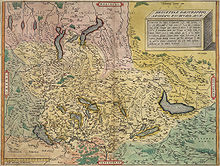
The Tuggenersee can still be clearly seen on Konrad Türst's map from 1496. It is mentioned for the last time in 1535, but is no longer shown on Aegidius Tschudi's Swiss map from 1538 or 1560.
In his "Complete description of the Swiss national» of Läufelfinger pastor describes Markus Lutz 1827 "unübersehliche swamps" , which according to current knowledge but on the Linthkorrektion are due. The “Geographical Lexicon of Switzerland” from 1911 mentions a reed south of Tuggen .
literature
- Ivo Auf der Maur (ed.): Columban von Luxeuil, monk rules. eos Klosterverlag, St. Ottilien 2007, ISBN 3-8306-7276-4
- 2000 full color pages. From the Neanderthals in the Drachenloch to the Alemanni in the Thurtal (Volume 1). Kantonaler Lehrmittelverlag, St. Gallen.
Web links
Individual evidence
- ↑ Linth-Zeitung (January 3, 2006): A swamp landscape arises .
- ^ Conrad Schindler : On the Quaternary of the Linth region . Contributions to the geological map of Switzerland, Delivery 169, 2004. Swisstopo Wabern BE. Terra plana? Magazine for culture, history, tourism and business . 3/2005, Sarganserländer Druck AG Mels. Preservation of monuments and archeology in the canton of St. Gallen 1997-2003, p. 340 ff.
- ↑ a b c Michael Johannes Umbricht: Which landscape do we want? Thinking models for the landscape of the future . Dissertation ETH Zurich , DISS ETH No. 15324, Zurich 2003
- ↑ The Waldstatt Einsiedeln , 1983, written by Wernerkarl Kälin on behalf of the Einsiedeln District Council, revised in 1993 by Paul Schönbächler, from 2000 continuously revised for the Einsiedeln district's website by Landschreiber Walter Kälin.
- ↑ a b c Anzeiger für Schweizer Geschichte, 1889, Tuggenersee, Zurich Central Library, Sig.KZ 211
- ^ Ferdinand Heinrich Müller: The German tribes and their princes . Berlin 1861.
- ↑ Konrad Türst (* 1455, † 1503), studied medicine in Basel, Paris, Bern and Pavia. He was also an important cartographer and created the first map of the Swiss Confederation in 1495–97, on parchment in a gentleman's perspective .
- ↑ Markus Lutz (Ed.): Complete description of the Swiss country or geographical-statistical hand-lexicon of all cantons, districts, districts, offices in the entire Confederation . 4 volumes, 2nd edition, Aarau 1827/28
- ^ Charles Knapp, Maurice Borel, Victor Attinger, Heinrich Brunner, Société neuchâteloise de geographie (editor): Geographical Lexicon of Switzerland . Volume 6: Tavetsch Val - Zybachsplatte, supplement - last additions - appendix . Verlag Gebrüder Attinger, Neuchâtel 1910, keyword Tuggen .
