
Floodplain

The flood plain , even Aue or Au (from Middle High German ouwe akin Latin aqua "water"), is the embossed by changing high and low water valley along a stream or river.
On the concept of the floodplain
Alluvial areas are banks of brooks or rivers, whose terrain forms and communities are shaped by the change between low and high water flow. As part of the river landscape, they are in permanent contact with the river itself and its catchment area.
Floodplains are constantly creating new habitats for pioneers among plants and animals. The moving water supplies the flooded soil with sufficient oxygen even during the growing season. The surface structures and habitat conditions are primarily determined by the river. Due to the alternation of flooding and dry traps, alluvial areas are very dynamic habitats with a wide variety of site conditions that are interlinked like a mosaic. Floodplain ecosystems are home to a large variety of plants and animals in a very small space.
Many floodplains in the northern hemisphere are products of the Holocene and were carved out of the lower terrace by the meltwater of the past cold ages (the current ice age ) . In the floodplain you can find fluvial sediments, such as sand and gravel, but mainly floodplain clay , which has led to the formation of typical floodplain soils such as Vega or Tschernitza .


The space has been greatly changed in the past centuries and adapted to human use. Today the floodplain is an extremely important and diversely used space for people and their activities. This explains the frequency of old place names ending in -au . The floodplain is considered a good settlement area , as it is flat and therefore particularly well suited for development and development. After the alluvial forest was cleared , the floodplain was mostly only used as pasture, as the soil was too moist for agricultural use.
The determination and designation of flood plains in a flood plain is the technical recording of the processes from natural and anthropogenic interaction between mean water runoff and flood runoff and serves to protect against floods . The technical flood protection with dyke constructions, especially in densely populated areas, has led to a constant displacement of the traditional floodplains in the floodplains at the beginning of the industrial age. With an increase in flood peaks, the risk of flooding the existing protection systems in the original floodplain areas with their settlement areas also increases.
By flood events on the Rhine , Oder , Danube and Elbe was clearly visible that the flood plain to the waters heard and a natural retention area represents. Since then, a broader public has also been aware of the fact that the floodplains should not be narrowed any further in settlement areas in the floodplain.
In Switzerland, the federal government placed floodplain areas under special protection in 1992 (Ordinance on the Protection of Floodplain Areas of National Importance . October 28, 1992).
Picture gallery of variously shaped floodplain landscapes

Rheinaue in Duisburg-Walsum / Dinslaken

Partly flooded Rheinaue in Duisburg-Walsum / Dinslaken
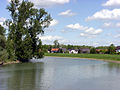
Rheinaue near Rastatt-Plittersdorf , behind the flood dam the town of Plittersdorf

Rheinaue near Rastatt-Plittersdorf

Rheinaue near Rastatt-Plittersdorf

Renaturated Indeaue between Eschweiler and Weisweiler
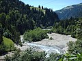
Montanes floodplain area on the Engstlige

Montanes floodplain area on the Engstlige
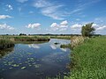
River meadow landscape in the Lower Oder Valley National Park

Floods in the Middle Elbe Biosphere Reserve

Cattle in the sandy Berkelaue

Okavango floodplains


See also
- Valley floor
- Hardwood meadow
- Softwood floodplain
- Donau-Auen National Park
- Lower Oder Valley National Park
Web links
- Nationwide floodplain protection. Federal Agency for Nature Conservation
- Institute for Geography and Geoecology - Auen Institute. Scientific work on river and floodplain ecology at the Karlsruhe Institute of Technology
- Analysis and assessment of ecosystem functions and services of large floodplains (PDF). In: Correspondence water management. Vol. 6, No. 9, 2013
literature
- Günter Matzke-Hajek : Live meadows . Association of German Water Protection V. (VDG), Bonn 2007, ISBN 978-3-937579-28-3 .
- Günter Matzke-Hajek: Adventure floodplains. Explore stream and river meadows . Part: For secondary school . Association of German Water Protection V. (VDG), Bonn 2007, ISBN 978-3-937579-30-6 .