
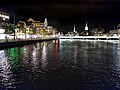
Limmatquai


The Limmatquai is the street that runs along the right bank of the Limmat in Zurich's old town . It leads from Bellevue down to Central . The Grossmünster , the Wasserkirche , many guild houses and the Zurich town hall are located on the Limmatquai . Most of the houses on the Limmatquai are classified as worthy of protection, the site of the Limmatraum is protected as a whole.
history
Over the centuries, the Limmat has become increasingly canalised in Zurich. The floor plan of old houses shows that the right bank of the Limmat is now up to 28 meters in front of the original bank. In the 12th and 13th centuries, the houses were built directly on the bank and accessed from Oberdorfstrasse and Niederdorfstrasse .
The Limmatquai as a continuous street was built in the 19th century: a first stage to the town hall 1823–1859, from the town hall to the Wasserkirche 1835/1836, and 1835–1839 from the Wasserkirche to Lake Zurich . The southernmost part, from the Grossmünster to the Bellevue, used to be called "Sonnenquai". The name disappeared in 1933 and since then the name Limmatquai has been used for the entire right bank of the Limmat.
After the Quai was built in 1859, it became the new main artery, as it flanked the entire length of the right bank of the old town. Elaborate buildings were subsequently erected here with typical forms of late classicism and neo-renaissance, such as the minster houses at the Grossmünster, the society house "zum Schneggen", the museum society, and the meat hall .

Traffic concept
The Limmatquai was one of the most important traffic arteries in the city center in the 20th century; apart from two tram lines , it was used by 20,000 cars and trucks every day at the end of the 1990s. The traffic calming of the Limmatquais was for years an urban political issue. Civil political forces, above all the local businesses, succeeded in delaying the implementation of the popular will for a car-free Limmatquai for years. In 2004 the Limmatquai was traffic-calmed and converted into a promenade by 2006: The tram stations were raised and the sidewalks were all paved. The lanes remained as a reserve for emergencies or diversion measures, while driving bans apply.
photos

At Central, photography ca.1880

Limmatquai - panoramic view (from the west)

View from the Münsterbrücke to the Haus zum Rüden (center) and the Zunfthaus zur Zimmerleuten (right)

From the central to the south
Below the Rudolf-Brun-Bridge


Web links
Individual evidence
- ↑ Gang dur Alt-Züri: The former Sonnenquai. Retrieved December 26, 2008.
- ^ Announcements of the Antiquarian Society in Zurich Antiquarian Society in Zurich (Ed.), 79 (2012), p. 18, ( Google books ).
- ↑ Media release by the City of Zurich (May 23, 2007): Even without a continuously navigable Limmatquai, traffic is rolling. ( Memento of April 3, 2015 in the Internet Archive ) Retrieved December 26, 2008.
Coordinates: 47 ° 22 '19.2 " N , 8 ° 32' 34.2" E ; CH1903: 683,397 / 247382