
Centum Prata
.JPG)
Centum Prata is a settlement from Roman times on the east bank of Lake Zurich in Kempraten , a district of Rapperswil-Jona in the canton of St. Gallen . The majority of the preserved commercial and residential buildings are in Kempraten, some in the Rapperswil district . Other sites are at St. Martin's Church in Busskirch and the parish church in Jona, as well as the remains of stakes from the pier between Rapperswil and Hurden , which are likely to have been directly related to the central settlement of Centum Prata .
Celtic predecessor settlement
Numerous archaeological finds show that the area around Rapperswil, Jona and especially Kempraten has been inhabited for at least 5000 years, before the turn of the century by Celts , later by Romans , the Gallo-Roman mixed population and immigrant Alemannic groups. The highlights of archaeological finds in Kempraten include a Neolithic ax workshop in Seegubel , body graves from the La Tène period , which indicate early settlement, and a large number of individual finds. It has not yet been clarified whether a Helvetic settlement Cambioratin (“Bay Hill”) existed on Kempratner Bay opposite today's Rapperswil Castle Hill.
Vicus Centum Prata
founding
_-_Meienbergstrasse_2012-01-16_14-31-20.JPG)

_-_Seewiese_-_Bahnhof_2013-02-25_14-43-46_(P7700).JPG)

After the conquest by Drusus and his brother Tiberius (Emperor Tiberius Claudius Nero from 14 to 37 AD), the area was on the right (eastern) bank of Lake Zurich in the border area between the Roman provinces of Raetia ( Raetia ) and Germania superior (Upper Germany).
Centum Prata was built around 40 AD as a street settlement at the intersection of the streets of Zurich (Latin Turicum ) and Winterthur ( Vitudurum ) and the Alpine route leading to Chur ( Curia Raetorum ) and Italy. On the other hand, Kempraten was also an economic center for the surrounding area, which had living and utility rooms for craftsmen, tradespeople, boatmen and carters. The Vicus Centum Prata ( Kempraten ) became an important Roman settlement , which should have served to secure the provincial borders from the 1st to the 4th century AD.
location
The main street (today's Kreuzstrasse and Fluhstrasse) of the settlement lay parallel to the lake shore near the Kempraten Bay. The extension was over 300 meters in the north-south direction and around 200 meters in the west-east axis, with half-timbered and simple wooden houses in the first settlement phase. On the eastern edge was a burial ground . The center of the settlement extended around the so-called Römerwiese, today a residential development, in the center of which remains of walls and some exhibits from the excavations are accessible to the public, as well as other remains of stone residential and commercial buildings with the forum at Meienbergstrasse and in the cemetery of St. Ursula Chapel.
Commercial and residential buildings
Around 120 AD, after a major fire, stone buildings with inner courtyards were built in the settlement center. On the periphery stood simpler houses, so-called strip houses with long rectangular floor plans typical of the region . Commercial buildings faced the street, the residential areas were in the part of the building facing away from the street. In some of the backyards there was evidence of one to two-room smaller buildings as well as areas for gardens, pets, garbage pits and pottery ovens.
Public buildings
Public facilities such as the thermal baths are presumed to be in the vicinity of today's cemetery and a walled temple area with two Gallo-Roman temple temples , a fire altar and two chapels on the north-western (lake meadow south of Kempraten train station) edge of the settlement. On the arterial road to Vitudurum (Rütistrasse / Rebacker) a grave fire area with around 50 burials has been archaeologically recorded.
Gallo-Roman temple district
Explorations on the occasion of planning work for a residential development in November 2003 also showed Roman artifacts south of the railway embankment in Kempraten, which was built in 1894. On the edge of the settlement area, the excavation team of the St. Gallen cantonal archeology explored the Gallo-Roman temple district on an area of around 1500 square meters, the enclosed area of which is likely to have been around 900 square meters. In an older phase it was surrounded by a ditch, but the elongated, trapezoidal area was later separated by a wall.
The oldest datable structures in the temple area are long trenches, lined with unprocessed sandstone slabs, which served as drainage to drain the building site near the lake. Pottery from the backfill can be dated to around 100 AD.
There were two Gallo-Roman temples in the courtyard , and in the cella of the larger building (4.8 × 4.3 meters) made of sandstone blocks (4.8 × 4.3 meters) there were remains of a mortar floor. This was above the outside level at that time and was accessible via steps. The brickwork shows strong reddening of fire on the outside. Indications were found of an older timber construction phase of the building. The walls of the passage had presumably base foundations for columns or posts.
The second temple building (cella: 3.6 × 3.7 meters) was smaller, made of reading stones and was closed on the back by the courtyard wall. Several fragments of a perforated barrel bottom, which presumably served as a well, lay in a pit right next to the small temple.
The fragments of inscriptions and three escape tablets made of lead are particularly noteworthy among the finds secured in three pits with moist soil conservation, mostly from the 2nd and 3rd centuries AD . The inscriptions are base parts of two consecration altars and two fragments of a larger inscription. Among the pottery finds are the numerous remains of incense chalices. Other finds are offerings, including several fragments of Venus figurines of terracotta , two fragments of bronze Votivbeilchen and coins. Occasionally prehistoric litter finds were recovered.
Two capitals reworked into half-columns and further architectural fragments made of sandstone allow an impression of the structural design of the two sacred buildings. A fire altar stood in the central axis of the two temple buildings: coal residues in its vicinity can probably be connected to burn victims. Several successive pourings of gravel have been documented around the altar. Presumably there were other smaller wooden buildings in the temple area. A lime kiln from the 1st century AD came to light on the edge of the excavation. Three stone inscriptions were documented, including a building inscription, as well as a large number of ceramic, bone and botany finds, from which the experts entrusted with the evaluation hoped to gain in-depth knowledge about sacrificial and cult acts and the deities worshiped in the sanctuary. The mother goddess Magna Mater Kybele , handed down in writing, has so far only been found in the urban centers of Aventicum ( Avenches ) and Augusta Raurica ( Augst / Kaiseraugst ) in Switzerland . The excavations of the Gallo-Roman temple area in the Seewiese were completed in 2012.
Escape signs
Among the extensive finds are three escape tablets made of lead with ancient curses and magic spells, which are extremely rare in Switzerland and of which only about 100 are known from the Gallic and Germanic provinces of the Roman Empire. Only one of the three tablets, 10 × 10 centimeters wide and only 0.2 centimeters thick, is largely preserved. The mother goddess Cybele , who is venerated in Kempraten, is invoked , and the curses are directed against the perpetrators of burglary and theft: perpetrators and those who know about it " should lie in the dirt as this letter will lie in the dirt ". Also on the second, fragmentarily preserved tablet, the Magna Mater is invoked to punish the thief of a cloak. The third lead tablet is folded up and therefore illegible.
Forum
The forum at Meienbergstrasse housed a stone building on its eastern side (Rütistrasse) with two prominent front pillars, one of which has been reconstructed. The building was entered via a wide staircase and the main room was accessible via a double-leaf door. The foundation walls as well as the pivot points of the door leaves and the bolt hole have been preserved. Due to its central location and the column front, the building is interpreted as a temple complex. The large square in front of it was closed off by symmetrical side walls. In the west of the complex there was another stone building with columns, the outlines of which have not been preserved, but use as a curia or temple is not excluded.
Transport hub
Today's Kempratner Bucht was the transshipment point for goods that were transported on the Roman roads mentioned , over the wooden bridge Rapperswil – Hurden and on the waterway from Lake Zurich to Walensee. From here there was probably also a boat connection to the Gallo-Roman island sanctuary on the Ufenau . After the subjugation of Raetia by the Romans, the goods traffic in west-east direction already operated by the Helvetic population increased considerably, and the settlement reached its heyday in the second and early third centuries. With the immigration of the Alemanni, Kempraten lost its importance as the intersection of goods traffic.
Kempraten is one of the most important archaeological sites in the canton of St. Gallen. On the occasion of archaeological investigations in autumn 2004, the remains of mighty piles made of silver fir and oak were discovered between the modern bridge piers of the reconstruction of the historic piers between Rapperswil and Hurden , a further indication of the central function of the settlement. The planks like silver fir were according C14 analyzes by 165 n. Chr., At the beginning of the reign of Emperor Marcus Aurelius Antonius Augustus , like. A Roman fortification of today's castle hill of Rapperswil, with its strategically favorable position, through the vicus Centum Prata one kilometer away, is considered likely, although not archaeologically proven.
Gallo-Roman settlement
After the withdrawal of the Roman troops and administration to Italy around the year 401 (488), only little information is available. As elsewhere, the settlement in Kempraten-Lenggis probably continued to exist and the Gallo-Roman population is likely to have merged with the Alemannic wave of immigration in the 3rd and 5th centuries AD. In the Roman ruins, Alemannic body graves from the 7th century and a variety of objects and weapons from the entire history of settlement were found. Aegidius Tschudi describes in his chronicle a stone with a Roman inscription , which could mean the consecration stone from the parish church in Jona.
Surname
In post-Roman times, the vicus was named after the Latin name in Centoprato ("place of a hundred meadows") and was mentioned in a document in 863 as Centiprata , from which today's Kempraten for the district is derived.
Terracotta figurines from the so-called Roman meadow

iron nails and tools, Römerwiese

Pottery, Roman meadow

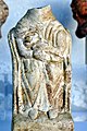
Grave gift, probably from Central Gaul, 2nd century AD, terracotta, Rapperswil City Museum

Roman consecration stone from the parish church in Jona
_-_R%C3%B6merwiese_-_Terrakotta-Fig%C3%BCrchen_(Kopien_von_Originalobjekten)_2012-01-16_14-26-02.JPG)
_-_R%C3%B6merwiese_-_Eisenobjekte_(N%C3%A4gel_%26_Werkzeuge)_2011-02-05_15-45-06.JPG)
_-_R%C3%B6merwiese_-_Fragmente_von_Keramikgef%C3%A4ssen_2013-02-25_14-55-55_(P7700).JPG)
.jpg)

literature
- Alois Stadler: Kempraten. In: Historical Lexicon of Switzerland .
- Georg Matter: The Roman settlement Kempraten and its surroundings . Published by the community of Jona, 2003.
- State Archives of the Canton of Zurich (Ed.): Small Zurich Constitutional History 1218–2000 . Published on behalf of the Directorate of Justice and Home Affairs on the day the Zurich Constitutional Council was constituted on September 13, 2000. Chronos, Zurich 2000. ISBN 3-905314-03-7 .
- G. Matter: The Roman vicus of Kempraten . In: JbSGUF 82, 1999, pp. 183-211.
- D. Hintermann: The Roman vicus of Kempraten . In: HA 106-108, 1996, pp. 128-136.
Web links
Individual evidence
- ↑ a b Alois Stadler: Kempraten. In: Historical Lexicon of Switzerland .
- ↑ a b c d Website of the canton of St. Gallen: The Roman vicus of Kempraten ( Memento of the original from November 8, 2014 in the Internet Archive ) Info: The archive link was inserted automatically and has not yet been checked. Please check the original and archive link according to the instructions and then remove this notice. (PDF; 1.2 MB), accessed on February 14, 2013
- ↑ a b c d e f Canton of St. Gallen, Annual Archaeological Report 2010: Rapperswil-Jona, Kempraten, Seewiese , accessed on February 20, 2013
- ↑ a b Canton of St. Gallen, Annual Archaeological Report 2011: Rapperswil-Jona, Kempraten, Seewiese , accessed on February 20, 2013
- ↑ Latin : Sic iaceat in micto quemadmodum haec epistula iacitura est .
- ↑ Tagblatt Ostschweiz, November 7, 2011: Roman escape signs found in Kempraten .
- ↑ Website of the Canton of St. Gallen: The forum in Kempraten ( memento of the original from January 23, 2016 in the Internet Archive ) Info: The archive link was automatically inserted and not yet checked. Please check the original and archive link according to the instructions and then remove this notice. (PDF; 1.1 MB), accessed on February 11, 2013
- ^ Rapperswil City Museum , Cantonal Archeology
- ^ Website of the Laboratory for Dendrochronology of the City of Zurich
Coordinates: 47 ° 14 '19.1 " N , 8 ° 48' 58.9" E ; CH1903: 704314 / 232884