
Via Gottardo


The Via Gottardo is a Swiss cultural hiking trail, the main route of which follows the mule track over the Gotthard Pass in the Swiss Alps , which was developed in the 13th century . The main route Via Gottardo leads in 20 stages from Basel via the Untere Hauenstein and the Gotthard Pass to Chiasso . It was opened as a national route (Wanderland Route No. 7) as part of the Swiss and SwitzerlandMobility cultural routes in June 2011.
history
With the development of the Schöllenen , the international trade route between Germany and Italy, which had been leading over the Bündner passes since Roman times, was replaced by the shorter Gotthard route . This made the mule track from Basel to Chiasso from 1230 to 1830 the most important transport and trade route and to this day the most important Alpine transversal route in Switzerland. Where there were navigable waterways, the mules loaded the goods onto Ledischiffs (Nauen) and these were shipped to the next landing point.
The infrastructure for transport was expanded at the stages of the Gotthard route. In addition to inns , goods transshipment points , hospices , haulers' cooperatives and horse changing stations , craftsmen such as blacksmiths , wagons and saddlers were needed. A department within the burgeoning small towns on the Gotthard route craft began its expertise Enterprises of early industrialization as iron foundries , textile industry and mechanical engineering building.
geography
The Via Gottardo passes the Jura , the Swiss Plateau , the Prealps and Alps, the Schächental , Reuss , Urserental and Valle Leventina valleys over a length of around 330 km (main route), follows the rivers Rhine , Aare , Wigger , Reuss , Gotthardreuss and Ticino , leads through the Schöllenen Gorge and along Lake Sempach , Lake Lucerne and Lake Lugano .
The journey on the Via Gottardo begins in the Rhine port city of Basel (Wanderland Route 7, East Arm) or in Bargen near Schaffhausen (Wanderland Route 77, West Arm) and continues through the Mittelland into Central Switzerland, where the two routes come together on Lake Lucerne. From here there is only one more route across the Alps to the south (Wanderland Route 7).
National route Basel – Chiasso
On the main route of Via Gottardo there are normal hiking signs marked yellow (hiking trail) or white-red-white (mountain hiking trail). Via Gottardo is also signposted on the same signposts as Wanderland Route No. 7 (No. 77 for the regional route).
Stage locations and sights
- 7.1 Basel– Liestal ⊙ , 24 km, 6 hours: Objects from the history of railways such as the Basel-Muttenz marshalling yard ( Wakker Prize 1983) and the Baselbieter railway hiking trail from Pratteln can be found on the way to the medieval town of Liestal, the capital of the canton of Basel-Landschaft . In Muttenz there is the fortified church of St. Arbogast and on the Wartenberg there are three medieval castle ruins and the modern lock point Wartenberg . Liestal was an important arena for the emerging direct democracy .
- 7.2 Liestal– Läufelfingen ⊙ , 19 km, 5 hours: It goes through the Ergolz and Homburg valleys to the Alemannic Läufelfingen, over the Basle Jura, along the historic Hauenstein route, past castles, castle ruins and the oldest railway bridges in Switzerland.

Bernoullisilo Basel

Fortified church Muttenz

Wartenberg castle ruins

Obertor in Liestal


- 7.3 Läufelfingen– Olten ⊙ , 8 km, 2 hours: The historic pass trail leads over the Unteren Hauenstein to Olten.
- 7.4 Olten– Zofingen ⊙ , 15 km, 4 hours: Along the Aare , you pass the fortress of Aarburg and into medieval Zofingen.
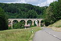
Rümligen viaduct

Aare and Aarburg
Zofingen


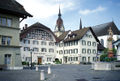
- 7.5 Zofingen– Sursee ⊙ , 26 km, 7 hours: The hiking trail leads through the Mittelland over the Santenberg with a view of Wauwilermoos to the small medieval town of Sursee on Lake Sempach .
- 7.6 Sursee- Lucerne ⊙ , 20 km, 7 hours The trek passes through Lucerne front land on the medieval "Old Basel or high road" to Lucerne and at the chapel of Mariazell , the ancient church of St. Martin at Kirchbühl and the town of Sempach over and over the Rotbachbrücke near Rothenburg .

Pilgrimage chapel Mariazell

Old wooden bridge Rothenburg

Foreign hospital in Altdorf


- 7.7 Lucerne– Altdorf ⊙ , 3 km, 1 hour: From Lucerne you take the sea route, which was preferred until the opening of the Axenstrasse in 1865, by boat to Flüelen and from there on foot to Altdorf, the capital of the Urkantons Uri .
- 7.8 Altdorf– Wassen ⊙ , 28 km, 1200 m ascent, 720 m descent, 8 hours: the narrow Urner Reuss valley has been shaped by Gotthard traffic for eight centuries. Medieval residential and defense towers, the mule track, old streets and bridges, churches and chapels, iron and motorways make the hike a varied journey through time.
- 7.9 Wassen– Andermatt ⊙ , 10 km, 800 m ascent, 280 m descent, 4 hours: The premodern traffic can be experienced through historical routes and bridges, former customs stations and hostels as well as the Schöllenen Gorge with the Devil's Bridge.

Göschenen visor tunnel during the construction of the Gotthard tunnel in 1872

Customs bridge and customs gate in Göschenen

Häderlis bridge above Göschenen

Devil's Bridge in the Schöllenen Gorge


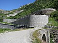
- 7.10 Andermatt – Gotthard Pass ⊙ , 13 km, 740 m ascent, 4 hours: From Andermatt the hiking trail leads to the pass village of Hospental with the former Sust building, customs station and inns and further over a section of the Postkutschenstrasse from 1830 and on the older mule track to the hospice on the Gotthard Pass ( 2106 m above sea level ).

St. Karl Chapel, Hospental

Gotthard Post 2013

Old hospice, Gotthard Pass


- 7.11 Gotthard Pass - Airolo ⊙ , 8 km, 1000 m descent, 3 hours: The historic mule track descends alongside the historic Tremola pass road to Airolo, past the first Gotthard fortresses, Fortress Motto Bartola and Forte Airolo .

Cappella dei Morti
Tremola above Airolo

Forte Airolo


- 7.12 Airolo– Rodi ⊙ , 14 km, 4 hours: The path runs along the Leventina valley along the Ticino river to Rodi.
- 7.13 Rodi– Lavorgo ⊙ , 13 km, 4 hours: After the restored former customs house in Uri and today's Dazio Grande Museum , the northern Ticino gate since 1561, the Piottino Gorge is one of the most important passages of the Via Gottardo.
- 7.14 Lavorgo– Biasca ⊙ , 19 km, 6 hours: The “Gate to Leventina” Giornico is home to several churches, museums, historic houses, fortifications and a battle memorial. From here it goes over the oldest access path, located on the hillside, to Leventina via Faidàl to Personico and Pollegio , where the AlpTransit visitor center is located.
- 7.15 Biasca– Bellinzona ⊙ , 24 km, 6 hours: Along the Ticino, the path leads through the Rivieratal and ends in the middle of the castles of Bellinzona .

former Uri customs house "Dazio Grande", Rodi-Fiesso

Piottino Gorge

Giornico 1478

Castelgrande Bellinzona


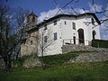
- 7.16 Bellinzona– Tesserete ⊙ , 20 km, 950 m ascent, 7 hours: Through the Isone valley , it goes up to Gola di Lago and down past the Capuchin monastery of Bigorio into the Capriasca region , while the Sopra- to the Sottoceneri changes.
- 7.17 Tesserete– Lugano ⊙ , 5 km, 1 1 ⁄ 2 hours: The path leads over the hill of San Bernardo, on which the medieval tower of the Redde desert is located and, further south, the Oratory San Bernardo viewpoint . In the parish church of San Ambrogio in Ponte Capriasca is one of the best copies of the “Last Supper” by Leonardo da Vinci.

Tesserete

Ponte Capriasca: Last Supper

Torre di Redde
Oratory of San Bernardo


- 7.18 Lugano– Morcote ⊙ , 12 km, 800 m ascent, 5 hours: after the ascent to Monte San Salvatore , the path leads down to Morcote.
- 7.19 Morcote– Mendrisio ⊙ , 14 km, 680 m ascent, 4 hours: the UNESCO World Heritage Site Monte San Giorgio is a 300 million-old mountain of fossils. You reach Mendrisio via Meride and Tremona .
- 7.20 Mendrisio– Chiasso ⊙ ⊙ , 13 km, 700 m ascent, 4 hours: The path ends in Switzerland's smallest geopark, the Parco delle Gole della Breggia in Morbio Inferiore above Chiasso.
Regional route Bargen – Küssnacht am Rigi
The regional hiking route no.77 leads in 7 day stages from Bargen in the north to Küssnacht am Rigi in the south:
- 1. Bargen– Schaffhausen ⊙
- 2. Schaffhausen– Rheinau ⊙
- 3. Rheinau– Eglisau ⊙
- 4. Eglisau– Kloten ⊙
- 5. Kloten– Zurich ⊙
- 6. Zurich– Zug ⊙
- 7. Zug– Küssnacht am Rigi ⊙ ⊙

Schifflände on the Rhine, Schaffhausen

Rheinau Monastery

Sust Horgen, Lake Zurich

Babenwaagbrücke, Sihlbrugg


Route 77 ends on the northern shore of Lake Lucerne in Küssnacht am Rigi. On the southern side of the lake, the continuation of the hike on Via Gottardo is signposted as Wanderland Route 7.
ViaStoria cultural route and historical traffic routes
ViaStoria researches and informs about the cultural routes. The historical traffic routes are protected with the inventory of historic traffic routes of Switzerland (IVS) in order to preserve them for future generations. From Altdorf to Airolo, Via Gottardo divides the path with Via Suworow . Various memorial plaques commemorate the legendary Alpine march ( Russian monument from 1898 in the Schöllenen, equestrian statue from 1999 on the Gotthard Pass, Suworowstein in the Tremola).
literature
- Sabine Bolliger, Massimo Colombo, Cornel Doswald, Martino Froelicher: Wanderland Switzerland. Volume 7: Via Gottardo. The official guide to the new Wanderland route 7 via Gottardo. AT Verlag, Baden 2011, ISBN 978-3-03800-571-1
- Cornel Doswald, Massimo Colombo, Martino Froelicher: Official Guide for Wanderland Switzerland: ViaGottardo. ViaStoria Center for Transport History / Swiss Hiking Trails, Baden 2011.
- Cornel Doswald: ViaGottardo. The Alps in front of your eyes, the south in your head? In: Adventure magazine Kulturwege Schweiz. Central Switzerland, edition 2009/2. ViaStoria Center for Transport History, Bern, pp. 36–51.
- Cornel Doswald: ViaGottardo. Transit route and traffic landscape. In: Adventure magazine Kulturwege Schweiz Nordwestschweiz. Edition 2007/2. ViaStoria Center for Transport History, Bern, pp. 44–59.
- Cornel Doswald: ViaGottardo. Today's hike through Switzerland. In: Adventure magazine Kulturwege Schweiz Ostschweiz. Edition 2008/1. ViaStoria Center for Transport History, Bern, pp. 36–49.
- Andriu Maissen: ViaGottardo. A journey through the heart of Switzerland. In: Adventure magazine Kulturwege Schweiz Uri-Tessin. Edition 2008/2. ViaStoria Center for Transport History, Bern, pp. 12–45.
- Hansruedi Matscher: ViaGottardo. Hell come out. In: On historical hiking routes through Switzerland, Volume 3. Coop Presse, Pfäffikon 2008, pp. 36–77.
- Christina Peege: Between History and Myth. In: The Landbote . July 23, 2011, Winterthur, p. 17 (archived on the website of Kulturwege Schweiz; PDF; 757 kB).
- Andreas Hügli, Raffael von Niederhäusern, Annlis von Steiger: Out and about on cultural paths . Teaching material for interdisciplinary teaching. Swiss Foundation Pro Patria, University of Education PHBern, ViaStoria - Center for Transport History (Ed.), Bern 2010.
Web links
Individual evidence
- ↑ Wanderland Route 7: Stages and digital hiking map
- ↑ Inventory of historical routes: Alte Baselstrasse or Hochstrasse ( Memento of the original from October 7, 2016 in the Internet Archive ) Info: The archive link was inserted automatically and has not yet been checked. Please check the original and archive link according to the instructions and then remove this notice.
- ↑ Swiss Cultural Routes Route 77: Stages