
St. Gallen Bridge Path
The St. Galler Brückenweg is an 8.2 kilometer hiking trail that starts at the train station in St. Gallen - Haggen and leads to Spisegg. The path marked as near tour 4 runs past 18 viaducts , wooden, concrete bridges and suspended walkways through the river landscape of the Sitter and Wattbach landscape nature reserve . At each bridge an information board contains details about the construction, year of construction and construction of the structures.

The bridges
The letters in brackets (A - R) correspond to the markings in the plan.
Haggen-Stein truss bridge (A)
After initial plans in 1884, today's bridge was completed in 1936/1937. It was assembled without scaffolding. The 355-meter-long truss bridge, in which 350 tons of steel were used, is one of the highest footbridges in Europe with a height of 98.60 meters. It replaces the old mule track down to Zweibruggen, over the Sitter and Wattbach and up the 364 steps of the Hundwiler ladder and connects the city of St. Gallen with Stein in the canton of Appenzell Ausserrhoden. The bridge was extensively renovated in 2009/2010.
Bridge at the former north mill (B)
In 1876 , the new crossing was built at this point, 95 feet next to the old (Hüsli) bridge , which had served as a replacement for various footbridges until 1787.
(Small) Hüsli Bridge over the Wattbach (C)
In Zweibruggen there was already a Hüsli bridge over the Wattbach in 1655. The current bridge was built in 1787 and thoroughly renovated in 1974. It has a wingspan of 14.20 meters and is 2.10 meters wide. It led to the "Hundwiler Ladder", a now eroded path on the St. Gallen side.
(Big) Hüsli Bridge over the Sitter (D)
The larger Hüsli Bridge is mentioned as early as 1479 as Schmidlinsbrugg and in 1655 as Brugg im Sittertal . A new building from 1710 was replaced by the existing wooden bridge in 1787 - beam polygons with triple struts, the portals are made of curved cross-beams - by Hans Jakob Altherr. Inside there are many ornate sayings with valuable dates.
Covered wooden bridge over the Urnäsch (E)
After a flood in 1778 had destroyed all bridges and footbridges along the Urnäsch , the famous Teufen builder Hans Ulrich Grubenmann built this 30 meter long and 6.5 meter high covered bridge (load-bearing polygonal beam made up of five fields) in 1780. Because of the many historical inscriptions it is also called the Talking Bridge .

Hüsli bridges near Zweibruggen

Zweibruggen: "Hüsli bridges"

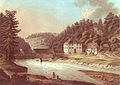
St.Gallen-Haggen with the Schlössli

Haggen – Stein truss bridge

"Talking bridge" over the Urnäsch
The prints with the abbot customs house around 1790

The new Kräzernbrücke from 1811
The Fürstenland Bridge

Sitter Viaduct BT / SOB


Covered wooden bridge over the Sitter (F)
The covered wooden bridge over the Sitter (mule path from Herisau to St. Gallen), built in 1800 by the St. Gallen monastery , is 22.40 meters long and 3.42 meters wide as a seven-field polygon with triple struts . Today it is still fully functional and approved for vehicles up to a total weight of 4 tons. The bridge has been owned by St. Gallisch-Appenzellische Kraftwerke AG (SAK) since 1915.
SOB-Sitter Viaduct (G)
The Sitter Viaduct of the Swiss Southeast Railway (SOB) was built between 1907 and 1910 and was officially opened on October 1, 1910 (at the same time the Bodensee – Toggenburg Railway was inaugurated). The 100 meter high viaduct is considered to be the highest standard gauge railway bridge in Europe with a stone and steel construction. The length of the viaduct is 365 meters, the central opening is bridged with a 120 m long steel girder that rests on sand and limestone pillars. Over 27,000 cubic meters of rock were needed to build it.
Cavern bridge of the St. Gallisch-Appenzell power plants (H)
The prefabricated, prestressed tubular beams form the framework of the cavern bridge built in 1973. A 5.10 meter wide road surface is concreted onto the supporting beam. The bridge serves as direct access to the cavern headquarters of the St. Gallisch-Appenzellische Kraftwerke AG (SAK).
SBB Sitter Viaduct (I)

The Sitter Viaduct, built in 1924/1925, 209 meters long and 63 meters high, with five vaults each 30 meters wide, clad with 18,000 tons of local quarry stone, has the old single-track steel construction bridge from 1856 as part of the expansion of the SBB St. Gallen line - Winterthur replaced on double track. A two-meter-wide, heavily frequented pedestrian and cycle path is now attached to the south side.
Kräzern Street Bridge (J)
After a first bridge in the 13th century and built from 1774 to 1778, according to abbot Beda Angehrn and muted named Bedabrücke for up to sechsspännige carts was in 1811 after three years of construction, today's stone bridge of builder Hans Ulrich Haltiner from Altstätten built. It has a length of 148 meters, a height of 25 meters and two vaults with a span of 26.40 meters each between the pillars made of molasse sandstone . In the years 1960–1976 the Kräzern-Strassenbrücke was fundamentally renovated with the accompanying widening of the roadway. The toll house at the eastern end of the bridge, also built by Haltiner in 1778, was used to collect the bridge toll until the 18th century .
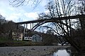
Fürstenland Bridge (K)
The Fürstenland Bridge, built by Charles Chopard in 1937–1941 and opened to traffic in 1941, is the replacement bridge for the Kräzernbrücke, which was no longer able to cope with the ever-increasing volume of traffic in the 1930s. The current 489 meter long and 60 meter above Sitter valley structure was selected from 47 submitted projects. The concrete twin arch has a span of 134 meters; 1,200 cubic meters of wood from the canton's forests were supplied for the scaffolding for concreting . The construction costs amounted to 3.6 million Swiss francs .
Footbridge for the Billenbergweg (L)
The 64 meter long and 1.5 meter wide footbridge over the Sitter is a popular transition to Billenberg and Abtwil . It was moved from the rake to its present location in 1879 and expanded with a wooden structure. After flood damage in 1895 and 1910, the wooden structure was replaced by iron girders in 1924 and the steel framework was renewed in 2002.
Rechenwald Bridge (M)
The Rechenwald Bridge was built in 1976 as a 70 meter long and 3.5 meter wide concrete bridge. It opens up the Tobel-Bruggen area .
Hanging walkway in the rake (N)
The footbridge, also popularly known as Ganggelibrogg , was built in 1882. With a width of 65.65 meters, it spans the sitter without an intermediate support. The two suspension ropes each have a diameter of 35 millimeters (for comparison: suspension bridge over the Argen = 133 mm, Golden Gate Bridge = 920 mm) and offer a load-bearing capacity of almost 10 tons (which corresponds to around 125 people). The cost of the 1.2 meter wide bridge built by the Romanshorn iron foundry was 10,000 francs.
Sitter Viaduct of the A1 (O)
The largest bridge structure in the canton of St. Gallen, the twin viaduct over the Sitter, carries the lanes of the approx. 410 km long A1 motorway ( Bardonnex - St. Margrethen ). The 655 meter long viaduct, built between 1984 and 1986, spans the river valley at a height of 64 meters with ten bridges (spans 45 to 80 meters). A footbridge for pedestrians and cyclists was subsequently attached to the viaduct, which was completed in the shell, below the roadway.
Filtrox AG's Sitter Bridge (P)
The 48 meter long (two fields of 24 meters each) and 5.2 meter wide concrete bridge replaced the first half-timbered bridge at Spisegg , built in 1877 . The construction costs amounted to 490,000 Swiss francs.
Covered Spisegg Bridge (Q)
At this point there was probably a footbridge as early as the 15th century and the first navigable bridge in 1592. After a lot of flood damage, the community of Gaiserwald had Johann Ulrich Schefer, builder of the St. Gallen Monastery, build the covered wooden bridge that still exists today based on the Grubenmann model. Until 1964 it was still used for regular postbus traffic .
New Spisegg Bridge (R)
Around 50 meters below the covered Spisegg Bridge, the new Spisegg Bridge, 61.8 meters long and 6.2 meters wide, was built between 1963 and 1964. The bridge consists of a prestressed T-bar with two main girders with parallel chords and has a span of 40 meters. The construction costs were around 490,000 francs.
Along the way
If you are not only interested in the viaducts, bridges and footbridges described above, you will always find some interesting sights along the way and a little off the road.
The St. Galler Brückenweg is located in the nature and landscape protection area Sitter and Wattbachlandschaft . It offers a natural river landscape and thus a habitat for many, partly protected and threatened plants and animals.
Near the starting point, the Haggen-Schlössli , built between 1642 and 1644, and the early Baroque St. Wolfgang Chapel offer the first cultural sights on the way: a coffered ceiling depicting the crucifixion in the Schlössli, which was built as a baroque country residence for Johann Boppart, and a baroque altar in the chapel .
A little below the Hüsli Bridge over the Sitter, you can still see the foundation walls of the water-powered Zweibruggen mill, which fell victim to a fire in 1902, on the left bank .
After the Fürstenlandbrücke you come to the former Sittertal dye works. This area was industrialized in 1840 and the side canal for dyeing was also built. The bridge over it has no name.
There are various restaurants along the St. Gallen Bridge Path between the start and end points.
facts and figures
The St. Gallen Bridge Path (max. 705 m above sea level ) is approximately 8 kilometers long. Hikers need about two and a half hours for this. The route has only moderate inclines (102 meters) and slopes (209 meters). It is well signposted in both directions.
See also
Web links
- St. Galler Brückenweg - 18 bridges at gps-tracks.com
- Bridge path St. Gallen at wandersite.ch
- St. Galler Brückenweg Directions with many pictures at walter-kalt.ch