
Sumvitg
| Sumvitg | |
|---|---|
 |
|
| State : |
|
| Canton : |
|
| Region : | Surselva |
| BFS no. : | 3985 |
| Postal code : | 7175 |
| Coordinates : | 714 247 / 176.51 thousand |
| Height : | 1056 m above sea level M. |
| Height range : | 868–3610 m above sea level M. |
| Area : | 101.88 km² |
| Residents: | 1158 (December 31, 2018) |
| Population density : | 11 inhabitants per km² |
| Website: | www.sumvitg.ch |
 Sumvitg |
|
| Location of the municipality | |
  |
|

Sumvitg ( , German and officially Somvix until 1985 ) is a municipality in the Surselva region of the canton of Graubünden in Switzerland . The community consists of numerous villages and hamlets, which are grouped into the four squadras Sumvitg , Cumpadials , Rabius and Surrein .
- North of the Vorderrhein lie Cumpadials (962 m above sea level), Clavadi (1233 m), Sumvitg (1056 m), Siltginas (1249 m), Sogn Benedetg (1277 m), Runs (1003 m), Luven bei Rabius (both 960 m) and Tschuppina (938 m).
- South of the Vorderrhein lie Pardomat-Dado (996 m), Falens (986 m), Laus (with Foppas , 1250–1280 m), Surrein (897 m) and in the elongated Val Sumvitg (German Somvixertal ) the hamlets of Portas (1180 m) and Val (1208 m) as well as the Tenigerbad ( Bogn Tenigia , 1305 m).
geography
The large community in the Surselva lies like a wedge from north to south across the Vorderrheintal. In the north the place borders on the canton of Glarus - the highest point is the Tödi (Romansh Piz Russein , 3614 m ) - and in the south the territory extends almost to the canton of Ticino . A small lake, the Lag da Laus, is located on the northern slope high above the Vorderrhein Valley. Opposite lies the Lag Serein lake group in the high mountains , while the water catchment for Axpo AG's Russein power plant is located in Val Russein near Barcuns on the north-western boundary of the municipality . The small reservoir is to be enlarged in the near future by raising the wall. Finally, in Val Sumvitg near Runcahez, there is an equalization basin and the water intake of Rein da Sumvitg by the Vorderrhein power stations .
A large part of the mountain range belongs to the municipality. In addition to the Tödi in the north, the Piz Muraun (2898 m) on the west, the Piz Vial (3168 m) on the south and the Piz Tgietschen (2858 m) on the east border of the municipality should be emphasized. Part of the Greina natural landscape, which is worth protecting, also belongs to Sumvitg.
Of the entire municipal area of almost 102 km², 4797 ha (= 47%) of mountains and another 2731 ha (= 27%) are covered by forest and wood. Of the 2526 ha that can be used for agriculture, 1956 ha are mountain pastures and alpine pastures. The remaining 129 hectares are settlement areas.
Neighboring communities are Disentis / Mustér , Glarus Süd in the canton of Glarus, Trun , Obersaxen , Lumnezia and Medel (Lucmagn) .
history
Mentioned in a document in 1175 as summovico ("uppermost village"), Sumvitg formed part of the Cadi , the monastic state of Disentis, and thus belonged to the Three Leagues of the Gray League.
In July 2000, gold prospector René Reichmuth found gold weighing 1.4 kilograms in Val Sumvitg. A 400 gram piece of Sumvitger Gold is exhibited in the Bündner Naturmuseum in Chur today .
Castle ruins "Tuor" , ancestral castle of the family of the same name from Sumvitg, former employers of the Disentis monastery.
The ruins of the castles Cartatscha , Friberg and Ringgenberg (Zignau) lie in the municipality of Trun .
coat of arms
Blazon : divided by silver and black, a six-pointed silver star in black, a black chess piece in silver
The coat of arms in the colors of the Gray League combines the star of the Maissen with the chess piece of the Lords of Hohenbalken, whose castle stood on the eastern edge of the Russeinertobel.
population
| Population development | ||||||||||
|---|---|---|---|---|---|---|---|---|---|---|
| year | 1850 | 1900 | 1950 | 1960 | 2000 | 2004 | 2010 | 2012 | 2014 | 2016 |
| Residents | 1353 | 1205 | 1674 | 2004 | 1313 | 1383 | 1281 | 1247 | 1240 | 1216 |
Sumvitg is one of the communities that have been able to preserve the traditional Romance language to this day. In the 2000 census, the main language was Romansh 88%, German 10%. The official and school language is Sursilvan . Of the 1383 residents at the end of 2004, 1355 were Swiss citizens.
traffic
Sumvitg is located on Hauptstrasse 19. The closest motorway connection is Reichenau on the A13 . The Rhaetian Railway's Vorderrheinlinie also serves the community. The two stations Rabius-Surrein and Sumvitg-Cumpadials are in the municipality . In summer the community operates a minibus to Val Sumvitg.
Attractions
- Village center of Sumvitg with the Catholic parish church S. Gion Battesta with one of the most melodious six-bell chimes in Switzerland
- Furthermore the town houses Casa Maissen and Casa Schmidt
- Alte Russeinerbrücke , wooden bridge over the Russeinertobel, historical border between the two parts of the Cadi ( Sursassiala and Sutsassiala )
- Caplutta Sogn Benedetg , chapel, 1988, architect: Peter Zumthor
- Atelierhaus Jacomet, in Surrein, architect: Werner Schmidt
- Greina plateau
- "Tuor" castle ruins, ancestral seat of the family of the same name
Personalities
- Clau Maissen (1621–1678), district judge of the Gray League
- Isabel Morf (* 1957), author of crime novels
- Leo Tuor (* 1959), writer
gallery
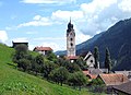
Sumvitg Church

Chapel in Runs

Rabius

Surrein

The former Tenigerbad thermal baths are located in Val Sumvitg


literature
- Aluis Maissen: Sumvitg / Somvix. A cultural-historical representation. Sumvitg 2001
- Monica Rüthers : Does a husband's murder belong in the history of a mountain village? Problems and opportunities of modern local historiography. In: Swiss History Journal , Volume 55/2005 ( digitized version )
- The municipalities of the canton of Graubünden. , Chur / Zurich 2003, ISBN 3-7253-0741-5
- Adolf Collenberg: Sumvitg. In: Historical Lexicon of Switzerland . 2013 .
- Adolf Collenberg: Tenigerbad. In: Historical Lexicon of Switzerland . 2012 .
Web links
Individual evidence
- ↑ Permanent and non-permanent resident population by year, canton, district, municipality, population type and gender (permanent resident population). In: bfs. admin.ch . Federal Statistical Office (FSO), August 31, 2019, accessed on December 22, 2019 .
- ↑ Possible expansion of the Russein power plant
- ^ Catholic parish church of St. Johannes Baptist
- ↑ Maissen House
- ^ Atelierhaus Jacomet
Breil / Brigels | Disentis / Mustér | Falera | Ilanz / Glion | Laax | Lumnezia | Medel (Lucmagn) | Obersaxen Mundaun | Safiental | Sagogn | Schluein | Sumvitg | Trun | Tujetsch | Vals
Former parishes: Andiast | Camuns | Castrisch | Cumbel | Sword | Duvin | Flond | Ilanz | Ladir | Lumbar clean | Luff | Morissen | Mundaun | Obersaxen | Peiden | Pigniu | Pitasch | Riein | Rueun | Ruschein | Safien | Slim | Schnaus | Sculms | Sevgein | Siat | St. Martin | Strada | Suraua | Surcasti | Surcuolm | Tenna | Tersnaus | Uors | Uors-Peiden | Valendas | Vella | Versam | Vignogn | Vrin | Waltensburg / Vuorz
Canton of Graubünden | Regions of the Canton of Graubünden | Municipalities of the Canton of Graubünden