
Coaz Hut
| Coazhütte SAC hut |
||
|---|---|---|
 View of the Coazhütte on the descent from Corvatsch |
||
| location | Above the Ley da Vadret in Val Roseg ; Samedan , Upper Engadin , Canton of Graubünden , Switzerland ; Valley location: Pontresina | |
| Mountain range | Bernina group | |
| Geographical location: | 784 352 / 139720 | |
| Altitude | 2610 m above sea level M. | |
|
||
| owner | SAC Rätia | |
| Built | 1964, expanded in 1982 | |
| Construction type | hut | |
| Usual opening times | Mid-June to early October, early March to mid-May | |
| Web link | Coaz Hut | |
| Hut directory | SAC | |

The Coazhütte ( Rhaeto-Romanic in the idiom Puter Chamanna Coaz ) is a mountain hut of the Swiss Alpine Club (SAC) in the Bernina group . It lies at an altitude of 2610 m above sea level. M. above the Lej da Vadret in Val Roseg , in the municipality of Samedan . The hut is named after the first person to climb Piz Bernina , Johann Wilhelm Coaz . It is easy to reach via the middle station of the Corvatsch cable car and offers 80 beds in summer and a shelter for ten people in winter.
history
In 1877 a small stone hut named Chamanna Mortèl was built by the SAC Bernina section. In the 1920s the hut became the property of the Rätia Section .
In 1926 it was replaced by a new hut at 2385 m above sea level. M. , which was given the name Chamanna Coaz for the first time .
In 1951, following the withdrawal of the Roseg slope subsidence first detected at the site of the hut, canceled the cottage in 1964 as a consequence and was replaced by a hut at the current location.
Jakob Eschenmoser , the most important architect at SAC-Hütten in the 20th century, was responsible for the conception and design of the new building from 1964 .
The hut was extended in 1982 with a side extension and for the first time equipped with lighting powered by solar cells.
Approach
The hut can be reached all year round from Pontresina through the Val Roseg. It is possible to take a horse-drawn carriage to Hotel Roseg, after which a further three hours must be expected. In winter, downhill skiing on touring skis from the mountain station of the Surlej- Corvatsch cable car is possible in one hour, in summer there is an easy hiking trail from the cable car middle station, walking time around 2.5 hours.
Transitions
- Rifugio Marco e Rosa ( 3597 m ) Walking time: 6–7 hours via Fuorcla da la Sella
- Rifugio Marinelli ( 2120 m ) Walking time: 6 hours via Fuorcla da la Sella
- Tschiervahütte ( 2573 m above sea level ) difficult, path through scree, moraines and torrents
Mountaineering
- Piz Roseg ( 3937 m above sea level ) Walking time: 6.5 hours (route 163 or ski tour route 776)
- La Sella ( 3584 m above sea level ) Walking time: 4–5 hours (route 136 or ski tour route 773a)
- Piz Sella ( 3511 m above sea level ) Walking time: 4–5 hours (ski tour route 775a)
- Il Chapütschin ( 3386 m above sea level ) Walking time: 3 hours over the north ridge (route 104 or ski tour route 770b) or south-west ridge (route 106)
literature
- Jakob Eschenmoser: About mountaineering and building huts . Orell Füssli publishing house, Zurich 1973, ISBN 3-280-00648-1
- [1] Raised ground floor from July 4, 2020: Jakob Eschenmoser and the Alps - two-day hike to the Coaz hut
Picture gallery
Coazhütte on the ledge

Coazhütte with extension

Val Roseg and Laj da Vadret

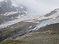
Roseg glacier


Web links
- Coazhütte on the ETHorama platform
Individual evidence
- ↑ Swiss Alpine Club SAC (ed.): Eschenmoser and new experiments . In: 150 years of hut construction in the Alps, part 2. The Alps 8/2009 ( Memento from March 4, 2016 in the Internet Archive )
- ↑ Chronology. Retrieved April 11, 2013 .