Vaudois Alps
| Vaudois Alps
Alpes Vaudoises
|
||
|---|---|---|
|
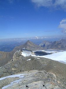
View from the Sommet des Diablerets to the northeast to the Oldenhorn |
||
| Highest peak | Le Sommet des Diablerets ( 3210 m above sea level ) | |
| location | Cantons of Vaud and Valais , Switzerland | |
| part of | Bernese Alps | |
| Classification according to | SOIUSA , subsection 12.III | |
|
|
||
| Coordinates | 580 758 / 128084 | |
The Vaudois Alps - French Alpes Vaudoises - are part of the Western Alps in Switzerland . They are also sometimes referred to as the western Bernese Limestone Alps and an extension of the Bernese Alps . According to SOIUSA , they are thus the western subsection 12.III according to SOIUSA of the Bernese Alps in the broader sense .
The highest peak is Le Sommet des Diablerets , 3210 m above sea level. M. achieved. In the alpine guides of the Swiss Alpine Club they are summarized with the Vaudois pre-Alps .
They are located in the cantons of Vaud and Valais in Switzerland .
Limitations according to SOIUSA
They border:
- in the north to the Vaudois Pre-Alps separated by Gryonne , the Col de la Croix and the Col du Pillon
- in the east to the Bernese Alps separated by the Sanetsch Pass
- in the south to the Grand Combin Group (in the Valais Alps ), separated by the Rhone
- in the southwest to the Mont-Blanc group (in the Graian Alps ), separated by the Rhone
- in the west to the Savoy Prealps , again separated by the Rhone
Most important peaks
- Les Diablerets - 3210 m above sea level M.
- Grand Muveran - 3051 m
- Dent de Morcles - 2969 m
Individual evidence
- ↑ Guide des Alpes et Préalpes vaudoises, de Guide Club Alpin Suisse
literature
- Sergio Marazzi: Atlante Orografico delle Alpi. SOIUSA . Pavone Canavese (TO), Priuli & Verlucca editori, 2005. ISBN 978-88-8068-273-8 (Italian)
- Sergio Marazzi, La “Suddivisione orografica internazionale unificata del Sistema Alpino” (SOIUSA) - the complete article with detailed illustrations (pdf; 1.53 MB) (Italian)

