Vaudois and Friborg Prealps (SOIUSA)
| Freiburg Alps
Vaudois and Friborg Prealps (SOIUSA)
|
|
|---|---|
|
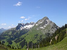
Le Tarent from La Pare to the east. |
|
| Highest peak | Le Taranto ( 2547 m above sea level ) |
| location | Cantons of Friborg , Bern , Vaud ; Switzerland |
| part of | Western alps |
| Classification according to | SOIUSA 14.I |
| Coordinates | 577 558 / 136783 |
The Vaudois and Friborg Prealps or Préalpes Vaudoises et Fribourgeoises is section 14.I and thus a summary of the Friborg Prealps and the Vaudois Prealps according to Sergio Marazzi's SOIUSA proposal for categorization, which is not internationally recognized . There it is part of the Swiss Prealps . They are located in western Switzerland in the cantons of Friborg , Bern and Vaud . The highest peak is Le Tarent ( 2547 m above sea level ) in Vaud . The Vanil Noir ( 2389 m above sea level ) is the highest point in the canton of Friborg.
Delimitation (according to SOIUSA)

They border:
- bounded in the north and west by the central plateau (from west to east) by Veveyse , Broye , Lac de la Gruyère , Sense
- in the southwest to the Chablais massif, the northeastern part of the Savoy Prealps separated by the Rhone Valley
- in the east to the Bernese Pre-Alps separated by Saane , Simme and Muscheren Sense
- bounded in the south by the Vaudois Alps by (west to east) the Gryonne Valley, Col de la Croix , Dar and Col du Pillon
Freiburg Alps
According to other subdivisions, the area is called the Friborg Alps , French Alpes Fribourgeoisrs , which borders the Emmental in the east, the Bernese Alps in the south and belongs to the Western Alps .
Highest peaks
- Le Taranto - 2548 m
- Gummfluh - 2458 m
- Vanil Noir - 2389 m
- Pic Chaussy - 2351 m
- Tour d'Aï - 2332 m
- Dent de Ruth - 2236 m
- Rochers de Naye - 2045 m
- Moléson - 2002 m
- Vanil des Artses - 1991 m
- Cape au Moine - 1941 m
- Dent de Jaman - 1875 m
- Monts Chevreuils - 1749 m
- La Berra - 1719 m
Web links
literature
- Sergio Marazzi: Atlante Orografico delle Alpi. SOIUSA . Pavone Canavese (TO), Priuli & Verlucca editori, 2005. ISBN 978-88-8068-273-8 (Italian)
- Sergio Marazzi, La “Suddivisione orografica internazionale unificata del Sistema Alpino” (SOIUSA) - the complete article with detailed illustrations (pdf; 1.53 MB) (Italian)
supporting documents
- ↑ SwissTopo
- ↑ Ernst Höhne: Knaurs Lexikon für Bergfreunde / The Alps between Matterhorn and Lake Constance . Droemer Knaur, Munich 1987, ISBN 3-426-26223-1 , p. 104 f .
- ↑ Mountain album based on Johannes Führer in "Bergwelt" 1980, p. 38 ff.

