
Piz Languard
| Piz Languard | ||
|---|---|---|
 Piz Languard in the evening light |
||
| height | 3261.86 m above sea level M. | |
| location | Canton of Graubünden , Switzerland | |
| Mountains | Livigno Alps | |
| Dominance | 8.6 km → Piz Boval | |
| Notch height | 947 m ↓ Forcola di Livigno | |
| Coordinates | 793 291 / 151 674 | |
|
||

The Piz Languard ( ) is a mountain peak east of Pontresina in the Engadin in the canton of Graubünden in Switzerland . The summit reaches a height of 3261.86 m above sea level. M. On the Piz Languard there is a surveying point of the 2nd order country triangulation (1903). The name is derived from the personal name Landward .
Location and surroundings

The Piz Languard group is part of the Livigno Alps . The municipal boundary between Pontresina and La Punt-Chamues-ch runs above the summit .
The Languard Pitschen ( 3,123 m ) is located 300 meters south of Piz Languard . Two and a half kilometers further south rises the Piz Albris ( 3165 m ), separated by the Fuorcla Pischa ( 2847 m ). The Piz Clüx ( 3130 m ) connects to the northwest of Piz Languard , where the ridge divides into two chains. A chain consists of Piz Muragl ( 3157 m ), Las Sours and extends to Munt da la Bês-cha ( 2647 m ) with the Segantini hut . The second chain continues north via Piz Vadret ( 3199 m ), Piz Uter and Munt Gravatscha . To the east of the Piz Languard are the Piz Prüna ( 3146 m ), the Piz Pischa ( 3138 m ) and Piz dal Fain ( 2907 m ). In the southwest, the mountain drops steeply into Val Bernina to Pontresina. In the north and east lies the Val Prüna , a branch of the Val Chamuera .
The valley location is Pontresina, a frequent starting point is the Alp Languard mountain station .
From Piz Languard you can see up to 257 kilometers to a point ( 45 ° 15 ′ 40.6 ″ N , 7 ° 7 ′ 57.2 ″ E ) near the Croce Rossa ( 3546 m ) on the border between the Italian Piedmont and the French region of Auvergne-Rhône-Alpes .
Survey point

There is a pyramid on Piz Languard , which is centered over the measurement symbol (iron mandrel) and serves to signal this measuring point, which serves as a connection point for trigonometric position determination . The national survey of 1903 (LV03) serves as the official basis for surveying work in Switzerland. The point determination is based on the triangulation method , in which directions, elevation angles and later also distances were measured between neighboring points.
Historical background
A signal was set up on Piz Languard in 1847. As the main point of the primary network of Southeast Switzerland in 1884 still exists today was the center Dorn set and centered about erected a pyramid. In 1895 an easement agreement was signed between the Federal Topographical Bureau and the municipality of Pontresina. The official national survey LV03 was introduced in 1903. In 1915, on the occasion of the creation of the 2nd and 3rd order triangulation networks, a revision of the point system and measurements took place. From 1965, the country's triangulation network was supplemented with electro-optical distance measurements. In 1994 there were follow-up measurements to the new satellite-based national survey 1995 (LV95) . The entire pyramid was completely overhauled in 1997 and the point system was checked.
Georgy's hut
87 meters in altitude below the summit on the south ridge of Piz Languard is located at 3175 m above sea level. M. the Georgys hut , the highest mountain hut in the canton of Graubünden. The hut has a large terrace, a dining room and a warehouse for 24 people. The hut was named after the Leipzig painter Wilhelm Georgy (* 1819; † 1887), who, together with the painter Emil Rittmeyer , was commissioned by Friedrich Tschudi to illustrate the natural history publication Das Tierleben der Alpen . Georgy often stayed in higher, remote regions, for example in the hut on Piz Languard, where he got to know nature in a wide variety of weather conditions and made studies. The large oil painting by the Bernina Group with chamois from Piz Languard is the result of a careful study of animals and nature in the area around Georgys Hut.
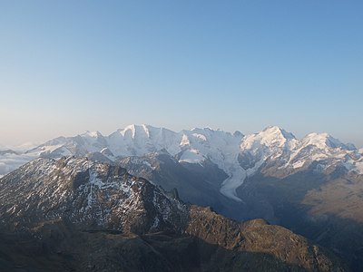
The view from Piz Languard to the Bernina group , below the Georgys hut .
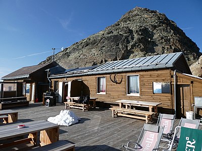
The Georgys Hut with Piz Languard in the background.

Wilhelm Georgy: Bernina group with chamois from Piz Languard .
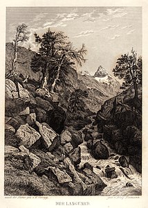
Wilhelm Georgy: The Languard .


Sunrise and sunset
The view from Piz Languard is extensive and extends from the Valais Alps in the west to far into the Eastern Alps . At the start of the Georgys Hut , the ascent is short and easy. This is why Piz Languard is often climbed with headlamps in the early morning so that you can be on the summit at sunrise . The sunset on Piz Languard is also often admired and the way back is made at dusk.
Routes to the summit
The mountain is popular with hikers and can be climbed on a path. A chair lift leads from Pontresina to Alp Languard at 2325 m above sea level. M. , from where you can climb up to the hut through Val Languard .
Over the south ridge
The usual ascent leads over the south ridge:
- Starting point: Pontresina ( 1805 m ), Alp Languard ( 2325 m ), Muottas Muragl ( 2454 m ), Bernina Suot ( 2045 m ) or La Punt-Chamues-ch ( 1708 m )
- Via: Plaun da l'Esen, Georgy's hut
- From Pontresina or Alp Languard directly to Plaun da l'Esen
- From Muottas Muragl via Segantinihütte ( 2732 m ) to Plaun da l'Esen
- From Bernina Suot via Plaun Graund, Val Pischa, Fuorcla Pischa ( 2847 m ) to Plaun da l'Esen
- From La Punt-Chamues-ch via Val Chamuera, Val Prüna, Fuorcla Prüna ( 2835 m ), Fuorcla Pischa ( 2847 m ) to Plaun da l'Esen
- 4 hours from Pontresina or 2½ hours from Alp Languard
- 4 hours from Muottas Muragl
- 5 hours from Bernina Suot
- 7 hours from La Punt-Chamues-ch
From Pontresina over the northwest ridge
- Starting point: Pontresina ( 1805 m ) or Alp Languard ( 2325 m )
- Via: Fuorcla Clüx ( 2994 m )
- Difficulty: WS
- Time required: 5 hours from Pontresina, 3½ hours from Alp Languard
Via Fuorcla Muragl and the northwest ridge
- Starting point: Punt Muragl ( 1738 m ), Muottas Muragl ( 2454 m ) or La Punt-Chamues-ch ( 1708 m )
- Via: Fuorcla Muragl ( 2891 m ), east flank of Piz Clüx , Fuorcla Clüx ( 2994 m ), northwest ridge
- From Punt Muragl via Alp Muragl, Margun, Lej Muragl to Fuorcla Muragl
- From Muottas Muragl south past the Tschimas da Muottas, Lej Muragl to Fuorcla Muragl
- From La Punt-Chamues-ch via Acla Veglia, Serlas, Alp Prüna to Fuorcla Muragl
- Difficulty: WS , to Fuorcla Muragl EB and as a trail white-red-white highlighted
- Time required (2½ hours from Fuorcla Muragl):
- 6 hours from Punt Muragl
- 4 hours from Muottas Muragl
- 6½ hours from La Punt-Chamues-ch
About the northeast rib
- Starting point: La Punt-Chamues-ch ( 1708 m )
- Via: Acla Veglia, Serlas, Alp Prüna
- Difficulty: ZS
- Time required: 6 hours
Over the east ridge
- Starting point: La Punt-Chamues-ch ( 1708 m )
- Via: Acla Veglia, Serlas, Alp Prüna
- Difficulty: S , III +
- Time required: 7 hours
photos

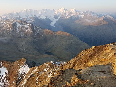
View to the south to the Bernina group with (from left to right) Piz Cambrena , Piz Palü , Bellavista , Piz Zupò , Piz Argient , Crast 'Agüzza , Piz Bernina , Piz Scerscen and Piz Morteratsch . In front of the Morteratsch Glacier , in the front left the Piz Albris .
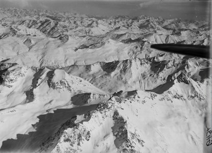
Piz Languard (under the wing) on an aerial photo from 1919.
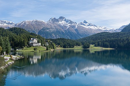
Lake St. Moritz, in the background (from left to right) Munt da la Bês-cha , Las Sours , Piz Muragl and Piz Languard.


literature
- Bernard Condrau, Walter Candinas: club guide, Bündner Alps . Middle Engadine and Poschiavo. 2nd Edition. tape X . Verlag des SAC, 1984, ISBN 3-85902-039-0 , p. 168-170 .
- National map of Switzerland, sheet 1257 St. Moritz, 1: 25,000, Federal Office of Topography, 2015 edition.
Web links
- Georgy's hut
- hikr.org: Piz Languard
- Calculated 360 ° panorama from Piz Languard
Individual evidence
- ↑ Andrea Schorta: How the mountain got its name . Small Rhaetian name book with two and a half thousand geographical names of Graubünden. Terra Grischuna Verlag, Chur and Bottmingen / Basel 1988, ISBN 3-7298-1047-2 , p. 97 .
- ↑ SAC Club Guide Bündner Alpen 10 "Middle Engadin and Puschlav"
- ↑ Calculated 360 ° panorama ( U. Deuschle ; information ) from Piz Languard