
Las Sours
| Las Sours | ||
|---|---|---|
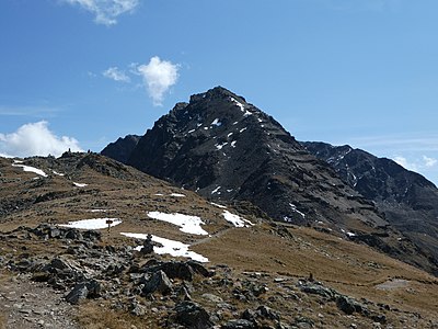
 v. l. No. Muottas Muragl , Piz Uter , Crasta Burdun , Munt da la Bescha , Piz Vadret , Las Sours, Piz Muragl and Piz Languard - taken from Lake St. Moritz . |
||
| height | 3007 m above sea level M. | |
| location | Canton of Graubünden , Switzerland | |
| Mountains | Livigno Alps | |
| Dominance | 0.33 km → Piz Muragl | |
| Notch height | 53 m ↓ ridge between Las Sours and Piz Muragl | |
| Coordinates | 791 065 / 153001 | |
|
||
| Normal way | Over the northwest ridge | |
| particularities | Has a double peak | |
 Main peaks of Las Sours ( 3008 m , left) and Piz Muragl (right) |
||

Las Sours ( Rhaeto-Romanic , from the Latin soror for 'The Sisters') is a mountain with double peaks east of Pontresina in the canton of Graubünden in Switzerland . The west summit has a height of 2978 m above sea level. M. , the main summit is 3007 m high. In the SAC club guide the heights are given as 3008 m and 3038 m , which is probably a mistake, as P. 3038 is on the northwest ridge of Piz Muragl.
The Sours are often climbed due to the proximity to the Muottas Muragl and Alp Languard mountain stations .
Location and surroundings

The Sours belong to the Piz Languard group, a subgroup of the Livigno Alps . The municipal boundary between Pontresina and Samedan runs above the peaks . The Sours are bordered in the southwest by the Val Bernina and in the north by the Val Muragl .
The neighboring peaks include the Munt da la Bês-cha in the north-west, Piz Utèr , Il Corn and Piz Vadret in the north-east, and Piz Muragl , Piz Clüx and Piz Languard in the south-east. The Segantinihütte is not far from the west foot of the Sours, from where a hiking trail leads to the west summit.
The valley location is Pontresina, frequent starting points for ascents are the mountain stations of Muottas Muragl and Alp Languard .
The farthest visible point ( 45 ° 30 '45.1 " N , 7 ° 37' 35" O ) from the main peaks of the sours is the Monte Giavino ( 2766 m slm ), 20 km northwest of Ivrea in the Graian Alps in the Italian metropolitan city of Turin , region Piedmont and 209 km away.
Routes to the summit
Over the southeast ridge
- Starting point: Pontresina ( 1805 m ) or Alp Languard ( 2327 m )
- Via: Foura da l'Amd'Ursina
- Difficulty: ZS
- Time required: 4 hours from Pontresina or 2½ hours from Alp Languard
Over the northwest ridge
- Starting point: Muottas Muragl ( 2454 m ), Pontresina ( 1805 m ) or Alp Languard ( 2327 m )
- Via: Fuorcla da la Chamanna
- Difficulty: EB , marked as a white-red-white hiking trail to the west summit - WS to the main summit
- Time required to get to the west summit: 2¼ hours from Muottas Muragl, 3¼ hours from Pontresina, 2 hours from Alp Languard, 1 hour from the Segantinihütte
- Time required to reach the main summit: + ½ hour
panorama

gallery
Las Sours, taken from the Segantini hut .

v. l. No. Piz Vadret , Piz Clüx , Piz Muragl , Las Sours and Munt la Bês-cha , recorded by Muottas Muragl .

View from the west summit over the Upper Engadine .


literature
- Bernard Condrau, Walter Candinas: club guide, Bündner Alps . Middle Engadine and Poschiavo. 2nd Edition. tape X . Verlag des SAC, 1984, ISBN 3-85902-039-0 , p. 175 .
- National map of Switzerland, sheet 1257 St. Moritz, 1: 25,000, Federal Office of Topography, 2015 edition.
Web links
- Calculated 360 ° panorama of Las Soras
- Tour reports on www.hikr.org (main summit)
- Tour reports on www.hikr.org (Westgipfel)
Individual evidence
- ↑ Andrea Schorta: How the mountain got its name . Small Rhaetian name book with two and a half thousand geographical names of Graubünden. Terra Grischuna Verlag, Chur and Bottmingen / Basel 1988, ISBN 3-7298-1047-2 , p. 133 .
- ^ Bernard Condrau, Walter Candinas: Club guide, Bündner Alpen . Middle Engadine and Poschiavo. 2nd Edition. tape X . Verlag des SAC, 1984, ISBN 3-85902-039-0 , p. 168-170 .
- ↑ Calculated 360 ° panorama ( U. Deuschle ; information ) from Las Sours