Piz Muragl
| Piz Muragl | ||
|---|---|---|
| height | 3156 m above sea level M. | |
| location | Canton of Graubünden , Switzerland | |
| Mountains | Livigno Alps | |
| Dominance | 1.42 km → Piz Vadret | |
| Notch height | 162 m ↓ Fuorcla Clüx | |
| Coordinates | 791 780 / 152673 | |
|
|
||
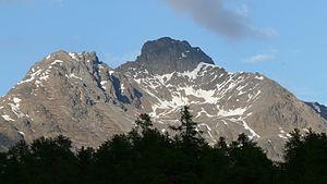
The Piz Muragl (possible from the Latin mora 'pile of stones', i.e. moriculu or morale with the influence of the Rhaeto-Romanic müraglia 'walls') is a mountain east of Pontresina in the canton of Graubünden in Switzerland . The mountain has a double peak , which is particularly proud and imposing from the north. The eastern tip is at 3156 m above sea level. M. the higher, while the western tip ( 3150 m above sea level ) more upstream to the west, is most striking. Because of the extensive view of the Bernina group and the landscape of the Upper Engadin, as well as the easy accessibility with the Muottas Muragl cable car, the summit is often visited in both winter and summer.
Location and surroundings
The Piz Muragl belongs to the Piz Languard group, a subgroup of the Livigno Alps . The municipal boundary between Pontresina and Samedan runs above the summit . The Piz Muragl is bordered in the southwest by the Val Bernina and in the north by the Val Muragl .
The neighboring peaks include Munt la Bês-cha and Las Sours in the north-west, Piz Clüx and Piz Languard in the south-east, and Piz Vadret and Il Corn in the north-east.
The most distant visible point ( 45 ° 16 ′ 54 ″ N , 7 ° 3 ′ 2.6 ″ E ) from Piz Muragl is the Pointe de Charbonnel ( 3752 m ) southeast of Bessans in the Graian Alps in the Savoie department , Auvergne region -Rhône-Alpes , France and is 261 km away.
Piz Muragl had two glaciers on the north and east sides. Today, however, they are almost gone.
The valley location is Pontresina; frequent starting points are Muottas Muragl and Alp Languard .
Routes to the summit
Summer routes
From Pontresina, over the southwestern foothills
- Starting point: Pontresina ( 1805 m ) or Alp Languard ( 2327 m )
- Via: western foothills to the western tip, then to the highest elevation
- Difficulty: WS
- Time required: 3 hours from Pontresina or 1½ hours from Alp Languard
From Pontresina, over the northwest ridge
- Starting point: Pontresina ( 1805 m ) or Alp Languard ( 2327 m )
- Via: Foura da l'Amd'Ursina
- Difficulty: ZS
- Time required: 3½ hours from Pontresina or 2 hours from Alp Languard
Crossing the ridge from Las Sours
- Starting point: Las Sours ( 3007 m )
- Via: northwest ridge
- Difficulty: ZS
- Time required: 2 hours
- Note: For routes to Las Sours, see the Las Sours article
From the Punt Muragl over the northwest ridge
- Starting point: Punt Muragl ( 1738 m ) or Muottas Muragl ( 2454 m )
- Via: Lej Muragl
- Difficulty: ZS
- Time required: 4½ hours from Punt Muragl, 2¾ hours from Muottas Muragl, 1½ hours from Lej Muragl
From Punt Muragl over the northern flank
- Starting point: Punt Muragl ( 1738 m ) or Muottas Muragl ( 2454 m )
- Via: Lej Muragl
- Difficulty: ZS
- Time required: 4½ hours from Punt Muragl, 2¾ hours from Muottas Muragl
Winter routes
From Muottas Muragl
- Starting point: Muottas Muragl ( 2454 m )
- Via: Tschimas da Muottas, Lej Muragl, Gianda Viva, north of Piz Clüx , ski depot at 3070 m
- Exposures: SW, NW
- Difficulty: WS
- Time required: 3 hours
Departure to Pontresina
- End: Pontresina ( 1805 m )
- Via: Costa dals Süts, Alp Languard, north of God Languard
- Exposures: S, SW
- Difficulty: ZS +
- Note: Protected area above Pontresina
gallery
v. l. No. Piz Vadret , Piz Clüx , Piz Muragl, Las Sours and Munt la Bês-cha , recorded by Muottas Muragl . The top summit of Piz Muragl (right) is the west summit, the less prominent summit (left) is the main summit.
Main peak of Las Sours and the western tip of Piz Muragl (right).
literature
- Bernard Condrau, Walter Candinas: club guide, Bündner Alps . Middle Engadine and Poschiavo. 2nd Edition. tape X . Verlag des SAC, 1984, ISBN 3-85902-039-0 , p. 172-174 .
- Vital Eggenberger: Ski tours Graubünden South . Verlag des SAC, 2010, ISBN 978-3-85902-301-7 , pp. 385 .
- National map of Switzerland, sheet 1257 St. Moritz, 1: 25,000, Federal Office of Topography, 2015 edition.
Web links
- 360 ° panorama from Piz Muragl
- Tour reports on www.hikr.org
Individual evidence
- ↑ Andrea Schorta: How the mountain got its name . Small Rhaetian name book with two and a half thousand geographical names of Graubünden. Terra Grischuna Verlag, Chur and Bottmingen / Basel 1988, ISBN 3-7298-1047-2 , p. 107 .
- ↑ Calculated 360 ° panorama ( U. Deuschle ; information ) from Piz Muragl


