Lac Blanc
| Lac Blanc | ||
|---|---|---|

|
||
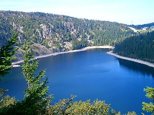
| Lac Blanc with a view of the Hautes Chaumes and the ski slopes of the Col du Calvaire | ||
| Geographical location | Haut-Rhin department , France | |
| Data | ||
| Coordinates | 48 ° 7 '28 " N , 7 ° 5' 40" E | |
|
|
||
| Altitude above sea level | 1052 m | |
| surface | 29 hectares | |
| Maximum depth | 72 m | |
| Middle deep | 11 m | |
The Lac Blanc ( "White Lake") is of a size of 29 hectares is the largest lake on the eastern side of the Vosges mountains in the Haut-Rhin region Grand Est . The Ice Age mountain lake lies at an altitude of 1052 m above Orbey and Kaysersberg . The maximum depth of the lake is 72 meters.
The Lac Blanc is bordered in the west by the peaty plateau of the Hautes Chaumes , which drops steeply over 100 m on the lake shore to Lac Blanc. North above the lake is the Col du Calvaire with the winter sports area named after the lake.
There is a car park with a restaurant on the south bank of the lake. From here the ascent to the Rocher Hans and Observatoire Belmont viewpoints begins .
Together with Lac Noir to the south, Lac Blanc forms a pumped storage power plant . Night-time electricity is used to pump water from the deeper Lac Noir (“Black Lake”) into Lac Blanc and, when there is a peak demand, it is called up again from Lac Blanc.
Web links
Individual evidence
- ^ Lac Blanc, France. In: LakePedia. Accessed December 7, 2017 .
