
Wildenstein (Haut-Rhin)
| Wildenstein | ||
|---|---|---|
.svg)
|
|
|
| region | Grand Est | |
| Department | Haut-Rhin | |
| Arrondissement | Thann-Guebwiller | |
| Canton | Cernay | |
| Community association | Vallée de Saint-Amarin | |
| Coordinates | 47 ° 59 ′ N , 6 ° 58 ′ E | |
| height | 547-1,303 m | |
| surface | 9.86 km 2 | |
| Residents | 180 (January 1, 2017) | |
| Population density | 18 inhabitants / km 2 | |
| Post Code | 68820 | |
| INSEE code | 68370 | |
 Mairie and Post Wildenstein |
||

Wildenstein is a French commune with 180 inhabitants (as of January 1, 2017) in the Haut-Rhin department in the Grand Est region ( Alsace until 2015 ). She is a member of the Communauté de communes de la Vallée de Saint-Amarin .
geography
The municipality of Wildenstein is located in the headwaters of the Thur in the High Vosges and borders on Lorraine . Two prominent elevations in the west of the municipality are the Altenberg with 1197 m and the Batteriekopf with 1311 m above sea level. The municipality is part of the Ballons des Vosges Regional Nature Park .
history
From 1871 until the end of the First World War , Wildenstein belonged to the German Empire as part of the realm of Alsace-Lorraine and was assigned to the district of Thann in the district of Upper Alsace .
Population development
| 1910 | 1962 | 1968 | 1975 | 1982 | 1990 | 1999 | 2006 | 2017 |
|---|---|---|---|---|---|---|---|---|
| 443 | 189 | 241 | 168 | 205 | 189 | 211 | 198 | 180 |
Attractions
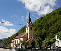
- Church of St. Peter and Paul in Wildenstein

North side
Northeast side


literature
- Le Patrimoine des Communes du Haut-Rhin. Flohic Editions, Volume 2, Paris 1998, ISBN 2-84234-036-1 , pp. 1073-1075.