Boknafjord
| Boknafjord | ||
|---|---|---|
|
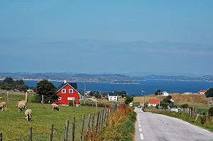
View from Bokn to the Boknafjorden |
||
| Waters | European Arctic Ocean | |
| Land mass | Scandinavian peninsula | |
| Geographical location | 59 ° 10 ′ 0 ″ N , 5 ° 40 ′ 0 ″ E | |
|
|
||
| Islands | Rennesøy , Bokn | |
|
Island world in the Boknafjorden |
||
The Boknafjord is the largest fjord in the Norwegian Fylke Rogaland . Its namesake is the island and commune of Bokn at its mouth .
The Boknafjord stretches far inland and is protected from the North Sea by the Tungeneset peninsula near Stavanger and the island of Karmøy near Haugesund . The radius of the fjord is 20 kilometers. Inside is an extensive island world, of which Rennesøy is the largest. The most famous branch of the fjord is the Lysefjord , which juts far to the east , with its impressive fells, Preikestolen and Kjerag .
It is shielded from the North Sea in such a way that its east side is one of the most famous fruit-growing areas in Norway. The northern German fruit varieties ( Altes Land ) introduced at the time of the German Emperor Wilhelm II are still being grown.
Significant is the Rogfast expressway , which connects Stavanger and Haugesund via the European route 39 , a remarkable engineering achievement of submarine tunnels and bridge construction, which connects the formerly isolated islands to the conurbations of western Norway . The fjord and the eastern Fjell massif divided the Fylke Rogaland into northern and southern Rogaland. This is how this landscape is still known today with the uniform name “ Ryfylke ”.
Neighboring municipalities or those in the fjord are Kvitsøy , Rennesøy , Finnøy , Tysvær , Bokn and Karmøy .


