Tysvær
| coat of arms | map | |
|---|---|---|

|
|
|
| Basic data | ||
| Commune number : | 1146 | |
| Province (county) : | Rogaland | |
| Administrative headquarters: | Aksdal | |
| Coordinates : | 59 ° 22 ′ N , 5 ° 33 ′ E | |
| Surface: | 425.48 km² | |
| Residents: | 11,065 (Feb 27, 2020) | |
| Population density : | 26 inhabitants per km² | |
| Language form : | Nynorsk | |
| Website: | ||
| politics | ||
| Mayor : | Sigmund Lier ( Ap ) (2015) | |
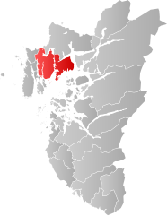
| Location in the province of Rogaland | ||

|
||
Tysvær is a municipality in the Norwegian Fylke Rogaland . The administrative center is in Aksdal. The municipality is centrally located in the Haugaland landscape .
Tysvær borders on Sveio and Vindafjord to the north and Haugesund to the west . The largest mountain in the commune is called Lammenuten ( 631 moh. ). The municipality's coastline is 220 km long.
history
Because of the poor living conditions in the region, Tysvær emigrated to America in the 19th century. Today a museum commemorates history (“Reisen til Amerika”).
The building blocks from Bausta, Hedlå, Kjempesver, Nessastøene, Øyraneset, Skårvamyrå, Store nessa and Toftøya are in the village.
Near the building stones of Resastaven , the building stones of Erland and those of Grinde
traffic
The community center Aksdal is about 13 kilometers southeast of Haugesund. Aksdal is a transport hub. This is where the year-round E 134 via Haukeli to Oslo and the E 39, the coastal road between Stavanger and Bergen , meet. Aksdal has a cinema and a swimming pool.
Web links
Individual evidence
