Suldal
| coat of arms | map | |
|---|---|---|

|
|
|
| Basic data | ||
| Commune number : | 1134 | |
| Province (county) : | Rogaland | |
| Administrative headquarters: | sand | |
| Coordinates : | 59 ° 28 ′ N , 6 ° 30 ′ E | |
| Surface: | 1,736.65 km² | |
| Residents: | 3,804 (Feb 27, 2020) | |
| Population density : | 2 inhabitants per km² | |
| Language form : | Nynorsk | |
| Website: | ||
| politics | ||
| Mayor : | Gerd Helen Bø ( Sp ) (2015) | |
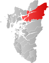
| Location in the province of Rogaland | ||

|
||
Suldal is a municipality in the northeast of the Norwegian Fylke Rogaland . The administrative center is in Sand.
Since the expansion of hydropower plants began in the 1960s, Suldal has become one of Norway's largest energy-producing municipalities. The share of total energy production in Norway is 8%. The damming of watercourses has led to major changes in nature, but also means a strong income for the community.
The salmon river Suldalslågen has been affected by the expansion, but the salmon have returned in the past few years.
Web links
Commons : Suldal - collection of images, videos and audio files

