Sandnes
| coat of arms | map | |
|---|---|---|

|
|
|
| Basic data | ||
| Commune number : | 1108 | |
| Province (county) : | Rogaland | |
| Coordinates : | 58 ° 52 ' N , 5 ° 43' E | |
| Surface: | 1,040.56 km² | |
| Residents: | 79,537 (Feb 27, 2020) | |
| Population density : | 76 inhabitants per km² | |
| Language form : | neutral | |
| Postal code : | 4306-4395 | |
| Website: | ||
| traffic | ||
| Railway connection: | Jærbanen | |
| politics | ||
| Mayor : | Stanley Wirak ( Ap ) (2011) | |
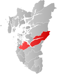
| Location in the province of Rogaland | ||

|
||
is a town andmunicipalitysouth ofStavangerinFylke RogalandinNorway. Sandnes is one of the most populous municipalities in Norway with 79,537 inhabitants (February 27, 2020).
The city of Sandnes was founded in 1860 and was for a long time identical to the municipality of Sandnes. In 1965, however, Sandnes was expanded through a merger with the rural municipalities of Høyland, Hetland and Høle. At that time, Sandnes was known as Norway's "pottery town" because of the large clay deposits in the area. A pottery museum reminds of this time. There is also a bicycle museum because of its status as Norway's bicycle city .
Sandnes is primarily important as a transport hub and as a commercial and industrial city. Sandnes Ulf is the city's football club.
On January 1, 2020, the municipality of Forsand was incorporated into the municipality of Sandnes.
Geography and traffic
The town of Sandnes is 15 km south of Stavanger and the two towns have expanded so far that they almost form a twin town. The municipality of Sola is in the west, Klepp , Time and Gjesdal in the south, Fylke Agder in the east and Hjelmeland , Strand and Stavanger in the north. The fjord Gandsfjorden cuts in north-south direction to the town center in Sandnes, where there is a harbor. To the south of the city center, the Gandsfjorden lowland continues south, in the form of the densely populated Ganddalen valley. The eastern part of the municipality is separated from the west by the Høgsfjord . The Lysefjord extends far to the east of the municipality.
The Oslo-Stavanger railway line also follows this valley, with a train station in Sandnes, before continuing on the west coast of the Gandsfjord to Stavanger. The European route 39, partly developed as a motorway, also leads from the southeast through Sandnes towards Stavanger. Reichsstraße 44 follows the railway line and connects Sandnes with the Jæren countryside in the south, while Reichsstraße 13 leads east to Ryfylke . A ferry across the Høgsfjord connects Sandnes with Forsand. Stavanger Airport is in the western neighboring municipality of Sola .
West of the Gandsfjord-Stadtmitte-Ganddalen line is the smaller, flat part of the municipality. This part is geographically part of the Jæren landscape and is characterized by intensive agriculture. To the east of this line the landscape is very hilly, with many small valleys, lakes, fjord bays, islands and summer houses. This part of the municipality is geographically more part of the Ryfylke landscape . Along the east side of the Gandsfjord is a mountain range with the town's 323 m high mountain , Dalsnuten. The highest mountain in the municipality, Bynuten, 672 m high, is located in the southeast of the municipality.
The city center itself mostly consists of relatively low-rise commercial buildings from the last 50 years.
Districts
The Sandnes municipality consisted of 13 districts until 2020. As of January 1, 2012, the districts had the following population figures:
| Lura | 8 198 inhabitants |
| Trones and center | 7 608 inhabitants |
| Stangeland | 7 460 inhabitants |
| Malmheim and Soma | 1 556 inhabitants |
| Sandved | 5 337 inhabitants |
| Ganddal | 6 431 inhabitants |
| Figgjo | 1 901 inhabitants |
| Austrått | 7 719 inhabitants |
| Bogafjell | 4 874 inhabitants |
| Sviland | 1 008 inhabitants |
| Hana | 7 775 inhabitants |
| Cave | 1 010 inhabitants |
| Riska | 6 786 inhabitants |
| not assigned | 151 inhabitants |
economy
Sandnes offers good shopping opportunities in the form of a number of specialty shops of all kinds and is used as a shopping location by the neighboring communities. Both the longest pedestrian shopping street in Norway, Langgaten (Lange Straße), in the city center, and Norway's largest shopping center, Kvadrat , in the northern part of Lura , are located in Sandnes.
Sandnes is known as Norway's cycling city . The bicycle manufacturer Øglænd DBS (founded in 1892) made its bicycles here for more than 100 years. Since 2000, DBS bikes have been produced outside of Norway, but Sandes still has a bike museum and many cycling routes for everyday cyclists and tourists.
The city is home to industry, which is predominantly located in the southern district of Ganddalen and in Lura and Forus in the north on the border with Stavanger. The oil industry is important for the region . Some IT -companies have in the community based. In the southern district of Figgjo is the same porcelain manufacturer Figgjo .
The old town hall with cinema, which was built between 1938 and 1941 according to plans by Gustav Helland and Sverre Brandsberg-Dahl, is an architectural monument . It is to be converted into an art house in the next few years. Sandnes also has a high school, vocational schools and a large cultural center. This was used in 2008 when Stavanger became the European Capital of Culture and Sandnes also participated.
Personalities
- Aaslaug Aasland (1890–1962), lawyer and politician
- Sigrid Stray (1893–1978), lawyer and women's rights activist
- Julie Ege (1943–2008), film actress
- Charles Tjessem (* 1971), cook
- Thomas Dybdahl (* 1979), musician
- Gry Tofte Ims (* 1986), soccer player
- Annette Obrestad (* 1988), poker player and web video producer
- Henrik Ingebrigtsen (* 1991), athlete
- Filip Ingebrigtsen (* 1993), athlete
- Jakob Ingebrigtsen (* 2000), athlete
- Roger "Nattefrost" Rasmussen, singer of the black metal band Carpathian Forest
Web links
- Tourist information (German)
- Sandnes. In: Store norske leksikon . Retrieved September 18, 2013 (Norwegian).
- Road map of Sandnes (it is possible to zoom in and out)
- Images by Sandnes
- SANDNES CITY MAP city map, the surroundings, the region, to & from Sandnes (German, Norwegian, English)
Individual evidence
- ↑ Statistisk sentralbyrå - Befolkning
- ↑ Navn på nye kommuner. February 19, 2019, accessed January 18, 2020 (Norwegian).
- ^ Sandnes commune: Sandnes commune plan 2007-2020, arealdel ( Norwegian ) In: sandnes.kommune.no . Sandnes Commune. Retrieved on January 1, 2007. ( Page no longer available , search in web archives ) Info: The link was automatically marked as defective. Please check the link according to the instructions and then remove this notice.

