Randaberg
| coat of arms | map | |
|---|---|---|

|
|
|
| Basic data | ||
| Commune number : | 1127 | |
| Province (county) : | Rogaland | |
| Coordinates : | 59 ° 0 ′ N , 5 ° 37 ′ E | |
| Surface: | 24.71 km² | |
| Residents: | 11,221 (Feb 27, 2020) | |
| Population density : | 454 inhabitants per km² | |
| Language form : | neutral | |
| Website: | ||
| politics | ||
| Mayor : | Jarle Bø ( Sp ) (2015) | |
| Location in the province of Rogaland | ||

|
||
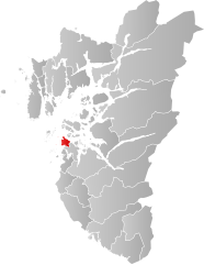
Randaberg is a municipality in the Norwegian Fylke Rogaland . It is located in the north of the Jæren region . The municipality borders on the municipalities of Stavanger , Sola and Kvitsøy . The majority of the residents live in the three localities Sentrum (310 households), Viste Hageby (315 households) and Grødem (135 households).
history
Some of Norway's earliest residents lived here. It is believed that the first humans were 12,000 BC. Came here. It is believed that Svarthola (also known as Vistehola ) was the accommodation for a group of 25 people (6000 BC). These people were mainly hunters and gatherers , from 4000 BC onwards. But they also started farming. From 2000 BC They were mainly occupied with agriculture.
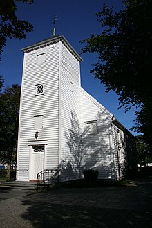
Around 1630 the old stave church was replaced by a simple wooden church. The altar panel was painted by Gottfried Hendtzschel , figurative jewelry was created by the carver Laurids Snekker . When the church was again too small in the middle of the 19th century , the wooden church, which is now located in the Randaberg-Sentrum district, was built in 1845 according to type plans by the palace builder Hans Ditlev Franciscus von Linstow . The equipment was partly taken over.
On July 1, 1922, Randaberg was separated from the Hetland commune as an independent commune , then called Herred . The first mayor (Ordfører) was Andreas Harestad . The old farm names have been retained in the names of the parts of the municipality: Tunge, Sande, Randaberg, Todnem, Harestad, Grødem, Rygg, Goa, Håland, Leikvoll, Viste, Vistnes, Raustein, Vistnes, Vistvik, Ytre Bø, Indre Bø, Tunge .
Shortly after the start of the Second World War , on April 9, 1940, Randaberg, like the entire west coast of Norway, was occupied as part of Operation Enterprise Weser Exercise . During the occupation, Randaberg was expanded into a fortress because of its strategic location on the Byfjord . The Randaberger Isak Rygh recorded the German positions and passed the drawings and maps on to the Norwegian resistance movement, for which he was sentenced in 1942 to imprisonment in a German concentration camp .
On May 11, 1945, the German occupiers were disarmed and captured by the British allies.
economy
Randaberg is still an agricultural commune now. The first potatoes each year are given to the royal family.
Attractions
- Vistnes Tunet, the only fully preserved farm from 1875 to 1900 in North Jæren
- Randaberg Kirke, built in 1845
- Tungenes fyr (lighthouse) with the maritime museum
- Former Wehrmacht command bunker in Bø
- Grødem kirke, built in 2000
sons and daughters of the town
- Bent Høie (* 1971), Norwegian politician
- Rune Holta (* 1973), Norwegian speedway driver
- Iselin Nybø (* 1981), Norwegian politician
literature
- O. Indrehus: Randaberg Herred. 1837-1937. Dreyers Forlag, Stavanger 1937.
- Hjørdis Horve: Randaberg Fortress. Randaberg Municipality, Randaberg 1995.
- Inge Bruland: Randaberg. Dagar ved Havet. Self-published, Randaberg 2003, ISBN 82-996760-0-2 .

