
Meroux
| Meroux | ||
|---|---|---|

|
|
|
| local community | Meroux-Moval | |
| region | Bourgogne-Franche-Comté | |
| Department | Territoire de Belfort | |
| Arrondissement | Belfort | |
| Coordinates | 47 ° 36 ' N , 6 ° 54' E | |
| Post Code | 90400 | |
| Former INSEE code | 90068 | |
| Incorporation | 1st January 2019 | |
| status | Commune déléguée | |
 Former Mairie de Meroux |
||

Meroux , partly meroux written (according to the pronunciation of the name), German earlier Mörlingen , is a village and a former French community with 866 inhabitants (at January 1, 2017) in the department de Territoire Belfort in the region Bourgogne Franche-Comté .
With effect from January 1, 2019, the former municipalities of Meroux and Moval were merged to form Commune nouvelle Meroux-Moval and have the status of a Commune déléguée there . The administrative headquarters are in Meroux.
geography
Meroux is located 368 m above sea level, about six kilometers south-southeast of the city of Belfort (as the crow flies). The village extends in the plains of the Burgundian Gate , in a wide hollow east of the valley of the Savoureuse and west of the plateau of Les Grands Bois.
The area comprises a section of the landscape in the area of the Burgundian Gate (Trouée de Belfort) with only weak relief. The central part of the area is occupied by the open Meroux basin, which is drained by the Dorfbach to the southeast to the Bourbeuse and thus to the Allaine . This valley basin is flanked by a plateau that averages 370 m. It is partly covered with arable and meadow land, partly with forest. There are three fortifications on the heights around Meroux. To the east the area extends into the vast forest area of Les Grands Bois . The floor of the Commune déléguée extends with a narrow strip to the northwest on the Bosmont on the edge of the Savoureuse valley, on which the highest elevation of Meroux is reached at 406 m.
history
Finds such as a dagger from the Bronze Age and a sword from the Iron Age point to a very early settlement in the municipality of Meroux. Meroux was first mentioned in a document in 1166 under the Latinized name Merodurum . The existence of the Benedictine priory of Saint-Nicolas has been documented since the middle of the 13th century, and in 1442 it became dependent on the Chapter of Belfort. In the middle of the 14th century the village came under the sovereignty of the Habsburgs. It was then assigned to the dominion of Rosenfels (Rosemont).
Meroux was badly affected by Swedish troops in 1632 during the Thirty Years War . The priory was destroyed and the nearby hamlet of Battumagny abandoned after the war. Together with the Sundgau , Meroux came to the French crown with the Peace of Westphalia in 1648. Since 1793 the village has belonged to the Haut-Rhin department , but in 1871 it remained as part of the Territoire de Belfort, unlike the rest of Alsace, in France. From 1908 to 1913 the Fort of Meroux and other fortifications in the area were built, which together formed a fortification ring around Belfort.
When the Belfort – Morvillars – Delle railway was opened on August 13, 1877 , Meroux was connected to the French railway network. Passenger traffic on the route was discontinued in 1992, the route to Morvillars is still in operation for the remaining freight traffic.
There was a change of area in 1972 when Meroux was merged with Moval to form the dual municipality of Meroux-Moval. On January 1, 1997, however, Moval was separated and regained its independence. Since 1998, Meroux was initially part of the Communauté d'Agglomération Belfortaine , which was merged into the Communauté d'agglomération Grand Belfort in 2017 .
population
| Population development | |
|---|---|
| year | Residents |
| 1962 | 472 |
| 1968 | 464 |
| 1975 | 479 |
| 1982 | 509 |
| 1990 | - |
| 1999 | 660 |
With its last 870 inhabitants (as of January 1, 2016), Meroux was one of the small communities in the Territoire de Belfort department. After the population had decreased in the first half of the 20th century (688 people were still counted in 1911), there has been significant population growth since the beginning of the 1980s.
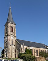
Attractions
The Saint-Nicolas church was rebuilt in the neo-Gothic style from 1885 to 1887 . The old rectory has been home to the Mairie (parish hall) since 1993.
See also: List of Monuments historiques in Meroux-Moval
- Church of St. Nicholas in Meroux


Economy and Infrastructure
Until well into the 20th century, Meroux was a village dominated by agriculture (arable farming, fruit growing and cattle breeding) and forestry. In addition, there are now some local small businesses. In the meantime the village has turned into a residential community. Many workers are therefore commuters who do their work in the agglomerations of Belfort and Montbéliard .
The village is well developed in terms of traffic. It is located on a departmental road that leads from Belfort to Froidefontaine . The expressway from the A36 motorway to Delle runs nearby . The closest connection to the A36 is around four kilometers away. There are other road connections with Moval and Vézelois. Meroux is connected to Belfort by a bus line. The Belfort-Montbéliard TGV station on the LGV Rhin-Rhône was built on the territory of the Commune déléguée of Meroux . The Belfort – Delle railway line , which runs past the TGV station, was reactivated after the timetable change on December 9, 2018, and received a new Meroux TGV station over the tracks of the Belfort-Montbéliard TGV station with the option of changing to the TGV.
literature
- Le Patrimoine des Communes du Territoire de Belfort. Flohic Editions, Paris 1999, ISBN 2-84234-037-X , pp. 116-118.