Montval-sur-Loir
| Montval-sur-Loir | ||
|---|---|---|
|
|
||
| region | Pays de la Loire | |
| Department | Sarthe | |
| Arrondissement | La Flèche | |
| Canton | Château-du-Loir | |
| Community association | Loir-Lucé-Bercé | |
| Coordinates | 47 ° 42 ' N , 0 ° 25' E | |
| height | 40-131 m | |
| surface | 26.99 km 2 | |
| Residents | 6,124 (January 1, 2017) | |
| Population density | 227 inhabitants / km 2 | |
| Post Code | 72500 | |
| INSEE code | 72071 | |
Montval-sur-Loir is a commune with 6,124 inhabitants (as of January 1 2017) in the Sarthe department in the region of Pays de la Loire ; it belongs to the arrondissement of La Flèche and the canton of Château-du-Loir . The inhabitants are called Montvallais .
On October 1, 2016, the previously independent municipalities of Château-du-Loir , Montabon and Vouvray-sur-Loir were merged to form Commune nouvelle Montval-sur-Loir .
geography
Montval-sur-Loir is located about 48 kilometers south-southeast of Le Mans on the Loir . Montval-sur-Loir is surrounded by the neighboring communities of Luceau in the north and north-west, Flée in the north and north-east, Marçon in the east, Dissay-sous-Courcillon in the south and south-east, Nogent-sur-Loir in the south, La Bruère-sur-Loir in the southwest, Vaas in the west and Lavernat in the northwest.
| District | former INSEE code |
Area (km²) | Population (2016) |
|---|---|---|---|
| Château-du-Loir (administrative headquarters) | 72071 | 11.46 | 5,631 |
| Montabon | 72203 | 7.48 | 747 |
| Vouvray-sur-Loir | 72384 | 8.05 | 782 |
Attractions
Château-du-Loir
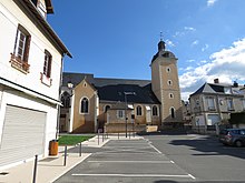
- Saint-Guingalois Church, Monument historique
Vouvray-sur-Loir
- Saint-Martin Church (12th-16th centuries)
Community partnerships
There are partnerships with the German community of Ganderkesee in Lower Saxony (since 1979) and with the British community of Westbury (since 2000) via Château-du-Loir.
Web links
Individual evidence
- ↑ Population figures retrospectively from January 1, 2016


