
Mansigné
| Mansigné | ||
|---|---|---|
.svg)
|
|
|
| region | Pays de la Loire | |
| Department | Sarthe | |
| Arrondissement | La Flèche | |
| Canton | Le Lude | |
| Community association | South Sarthe | |
| Coordinates | 47 ° 45 ′ N , 0 ° 8 ′ E | |
| height | 35-104 m | |
| surface | 36.31 km 2 | |
| Residents | 1,553 (January 1, 2017) | |
| Population density | 43 inhabitants / km 2 | |
| Post Code | 72510 | |
| INSEE code | 72182 | |
| Website | http://www.ville-mansigne.fr/ | |
.JPG) Mansigné parish hall (Mairie) |
||

Mansigné is a French commune with 1,553 inhabitants (as of January 1 2017) in the department of Sarthe in the region Pays de la Loire . It belongs to the arrondissement La Flèche and the canton Le Lude (until 2015: canton Pontvallain ). The inhabitants are called Mansignéens .
geography
Mansigné is about 29 kilometers south of Le Mans . Mansigné is surrounded by the neighboring communities of Requeil in the north, Pontvallain in the east, Coulongé in the southeast, Luché-Pringé in the south and southwest, Saint-Jean-de-la-Motte in the west and Oizé in the northwest.
Population development
| year | 1962 | 1968 | 1975 | 1982 | 1990 | 1999 | 2006 | 2013 |
| Residents | 1,407 | 1,302 | 1,292 | 1,250 | 1,255 | 1,355 | 1,516 | 1,603 |
| Source: Cassini and INSEE | ||||||||
Attractions
- Menhir La Brunerie
- Saint-Martin church from the 11th century
- La Guyardière mansion
- 15th century ruins of Fay Castle
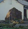
Menhir La Brunerie

Saint Martin Church

La Guyardière mansion

.JPG)

Parish partnership
The municipalities of the former canton of Pontvallain are partnered with the German municipality of Visbek in Lower Saxony.
Personalities
- Raymonde Dien (* 1929), politician (PCF)