
Courcelles-la-Forêt
| Courcelles-la-Forêt | ||
|---|---|---|
|
||
| region | Pays de la Loire | |
| Department | Sarthe | |
| Arrondissement | La Flèche | |
| Canton | La Flèche | |
| Community association | Pays Fléchois | |
| Coordinates | 47 ° 47 ' N , 0 ° 1' E | |
| height | 36-108 m | |
| surface | 19.6 km 2 | |
| Residents | 410 (January 1, 2017) | |
| Population density | 21 inhabitants / km 2 | |
| Post Code | 72270 | |
| INSEE code | 72100 | |
 Courcelles-la-Forêt town hall |
||

Courcelles-la-Forêt is a French municipality with 410 inhabitants (as of January 1 2017) in the department of Sarthe in the region Pays de la Loire . It belongs to the arrondissement of La Flèche and the canton of La Flèche (until 2015: canton of Malicorne-sur-Sarthe ). The inhabitants are called Courcellais .
geography
Courcelles-la-Forêt is located about 29 kilometers south-southwest of Le Mans . Courcelles-la-Forêt is surrounded by the neighboring communities of Mézeray in the north, La Fontaine-Saint-Martin in the east, Ligron in the south, Bousse in the southwest and Malicorne-sur-Sarthe in the west.
Population development
| 1962 | 1968 | 1975 | 1982 | 1990 | 1999 | 2006 | 2012 |
|---|---|---|---|---|---|---|---|
| 504 | 452 | 435 | 381 | 359 | 408 | 423 | 416 |
| Source: Cassini and INSEE | |||||||
Buildings and sights
- Saint-Jean church from the 12th century, alterations in the 14th century, monument historique
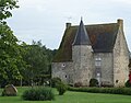
- Vadré Castle from the 17th century
- Old hostel, house from the 15th century
- 15th century Baudour mansion
- Wash house
- Les Vieilles-Courcelles estate with a pigeon tower

Saint-Jean church

Vadré Castle
Badour mansion

Pigeon tower on the Vieilles-Courcelles estate
.JPG)
.JPG)
.JPG)
.JPG)
Web links
Commons : Courcelles-la-Forêt - collection of images, videos and audio files