
Clermont-Créans
| Clermont-Créans | ||
|---|---|---|
|
||
| region | Pays de la Loire | |
| Department | Sarthe | |
| Arrondissement | La Flèche | |
| Canton | La Flèche | |
| Community association | Pays Fléchois | |
| Coordinates | 47 ° 43 ′ N , 0 ° 1 ′ W | |
| height | 27-107 m | |
| surface | 17.82 km 2 | |
| Residents | 1,264 (January 1, 2017) | |
| Population density | 71 inhabitants / km 2 | |
| Post Code | 72300 | |
| INSEE code | 72084 | |
| Website | http://clermont-creans.wifeo.com/ | |
 Town hall (Mairie) of Clermont-Créans |
||

Clermont-Créans is a French commune with 1,264 inhabitants (at January 1, 2017) in the Sarthe department in the region of Pays de la Loire ; it is part of the arrondissement of La Flèche and the canton of La Flèche . The inhabitants are called Clermontois .
geography
Clermont-Créans is located about 34 kilometers southwest of Le Mans on the Loir , which borders the municipality in the south. Clermont-Créans is surrounded by the neighboring communities of Ligron in the north, Saint-Jean-de-la-Motte in the north-east, Mareil-sur-Loir in the east, La Flèche in the south and west and Bousse in the north-west.
| Population development | ||||||||
|---|---|---|---|---|---|---|---|---|
| year | 1962 | 1968 | 1975 | 1982 | 1990 | 1999 | 2006 | 2013 |
| Residents | 844 | 839 | 779 | 826 | 930 | 1,000 | 1,128 | 1,272 |
| Source: Cassini and INSEE | ||||||||
Attractions
- 11th century Saint-Lambert church
- Saint-Symphorien Church from the 11th century
- old Saint-Denis church, former priory
- Oyré Castle from the 15th century, alterations from the 18th century
- Castle Créans from the 15th century, alterations from the 18th century, monument historique since 1905
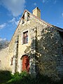
- former rectory from the 15th century
- Launay Castle from the 19th / 20th centuries century
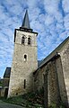
Saint-Lambert Church

Saint-Symphorien Church
old church of Saint-Denis

Old rectory

Oyré Castle

Créans Castle

Launay Castle
.JPG)

.JPG)
.JPG)


literature
- Le Patrimoine des Communes de la Sarthe. Flohic Editions, Volume 1, Paris 2000, ISBN 2-84234-106-6 , pp. 525-531.
Web links
Commons : Clermont-Créans - Collection of images, videos and audio files