
Ligron
| Ligron | ||
|---|---|---|
|
||
| region | Pays de la Loire | |
| Department | Sarthe | |
| Arrondissement | La Flèche | |
| Canton | La Flèche | |
| Community association | Pays Fléchois | |
| Coordinates | 47 ° 46 ′ N , 0 ° 1 ′ E | |
| height | 53-108 m | |
| surface | 13.48 km 2 | |
| Residents | 504 (January 1, 2017) | |
| Population density | 37 inhabitants / km 2 | |
| Post Code | 72270 | |
| INSEE code | 72163 | |
| Website | mairieligron72.fr/ | |
 Town hall ( Mairie ) of Ligron |
||

Ligron is a French municipality with 504 inhabitants (as of January 1 2017) in the department of Sarthe in the region Pays de la Loire . It belongs to the arrondissement of La Flèche and the canton of La Flèche (until 2015: canton of Malicorne-sur-Sarthe ). The inhabitants are called Ligronnais .
geography
Ligron is about 27 kilometers southwest of Le Mans . Ligron is surrounded by the neighboring municipalities of Courcelles-la-Forêt in the north, La Fontaine-la-Forêt in the northeast, Saint-Jean-de-la-Motte in the east and southeast, Clermont-Créans in the south and Bousse in the west.
Population development
| 1962 | 1968 | 1975 | 1982 | 1990 | 1999 | 2006 | 2013 |
|---|---|---|---|---|---|---|---|
| 480 | 406 | 351 | 337 | 338 | 358 | 936 | 498 |
| Source: Cassini and INSEE | |||||||
Buildings and sights
- Sainte-Marie-et-Saint-Anne church from the 12th century with additions and conversions from the 16th and 17th centuries
- Chapel of Saint-Laumer from the 12th century
- 14th century mansion of Saint-Laumer
- Saint-Laumer fountain
- 15th century manor house of La Sansonnière
- Manor of La Grande Poterie

Center with church of Sainte-Marie-et-Sainte-Anne

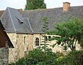
Chapel of Saint-Laumer
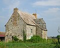
Manor of Saint-Laumer
Manor of La Grande Poterie

.JPG)


Web links
Commons : Ligron (Sarthe) - collection of images, videos and audio files