
Fillé
| Fillé | ||
|---|---|---|
|
||
| region | Pays de la Loire | |
| Department | Sarthe | |
| Arrondissement | La Flèche | |
| Canton | La Suze-sur-Sarthe | |
| Community association | Val de Sarthe | |
| Coordinates | 47 ° 54 ' N , 0 ° 8' E | |
| height | 35-73 m | |
| surface | 10.07 km 2 | |
| Residents | 1,494 (January 1, 2017) | |
| Population density | 148 inhabitants / km 2 | |
| Post Code | 72210 | |
| INSEE code | 72133 | |
| Website | http://mairie-fille.org/ | |
 Town hall (Mairie) of Fillé |
||

Fillé (also: Fillé-sur-Sarthe ) is a French municipality with 1494 inhabitants (as of January 1 2017) in the department of Sarthe in the region Pays de la Loire . It belongs to the arrondissement of La Flèche and the canton of La Suze-sur-Sarthe . The inhabitants are called Filléens .
geography
Fillé is about 13 kilometers south-southwest of Le Mans on the Sarthe . Fillé is surrounded by the neighboring communities of Voivres-lès-le-Mans in the north and north-west, Spay in the east and north-east, Guécélard in the south and east and Roézé-sur-Sarthe in the west and south-west.
Population development
| year | 1962 | 1968 | 1975 | 1982 | 1990 | 1999 | 2006 | 2013 |
| Residents | 501 | 470 | 617 | 744 | 836 | 1,086 | 1,486 | 1,535 |
| Source: Cassini and INSEE | ||||||||
Attractions
- Church, bombed and burned down in 1944, rebuilt 1947–1956
- Le Gros Chesnay castle from the middle of the 17th century
- 15th century mill
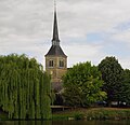
church

Le Gros Chesnay Castle

Watermill


Web links
Commons : Fillé - collection of images, videos and audio files