
Poillé-sur-Vègre
| Poillé-sur-Vègre | ||
|---|---|---|
|
||
| region | Pays de la Loire | |
| Department | Sarthe | |
| Arrondissement | La Flèche | |
| Canton | Loué | |
| Community association | Loué-Brûlon-Noyen | |
| Coordinates | 47 ° 55 ′ N , 0 ° 16 ′ W | |
| height | 38-96 m | |
| surface | 17.57 km 2 | |
| Residents | 617 (January 1, 2017) | |
| Population density | 35 inhabitants / km 2 | |
| Post Code | 72350 | |
| INSEE code | 72239 | |
| Website | http://www.poille-sur-vegre.com/ | |
 Town hall (Mairie) of Poillé-sur-Vègre |
||

Poillé-sur-Vègre is a French municipality with 617 inhabitants (as of January 1 2017) in the department of Sarthe in the region Pays de la Loire . The municipality belongs to the arrondissement of La Flèche and the canton of Loué . The inhabitants are called Poilléens .
geography
Poillé-sur-Vègre is located about 32 kilometers west-southwest of Le Mans on the Vègre . Poillé-sur-Vègre is surrounded by the neighboring communities of Avessé in the north, Chevillé in the northeast, Fontenay-sur-Vègre in the east, Asnières-sur-Vègre in the south and southeast, Auvers-le-Hamon in the west and southwest and Épineux-le- Seguin in the northwest.
Population development
| 1962 | 1968 | 1975 | 1982 | 1990 | 1999 | 2006 | 2013 | |
|---|---|---|---|---|---|---|---|---|
| 633 | 545 | 482 | 463 | 470 | 554 | 658 | 625 | |
| Source: Cassini and INSEE | ||||||||
Attractions
- Saint-Denis church
- Verdelles Castle

Saint-Denis church
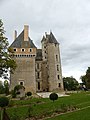
Verdelles Castle
_-_Wikip%C3%A9dia_takes_Sabl%C3%A9_et_environs.jpg)

literature
- Le Patrimoine des Communes de la Sarthe. Flohic Editions, Volume 1, Paris 2000, ISBN 2-84234-106-6 , pp. 320-324.
Web links
Commons : Poillé-sur-Vègre - Collection of images, videos and audio files