
Roézé-sur-Sarthe
| Roézé-sur-Sarthe | ||
|---|---|---|

|
|
|
| region | Pays de la Loire | |
| Department | Sarthe | |
| Arrondissement | La Flèche | |
| Canton | La Suze-sur-Sarthe | |
| Community association | Val de Sarthe | |
| Coordinates | 47 ° 54 ' N , 0 ° 4' E | |
| height | 33-74 m | |
| surface | 26.46 km 2 | |
| Residents | 2,626 (January 1, 2017) | |
| Population density | 99 inhabitants / km 2 | |
| Post Code | 72210 | |
| INSEE code | 72253 | |
| Website | http://www.roeze.fr/ | |
.JPG) Roézé-sur-Sarthe town hall |
||

Roézé-sur-Sarthe is a French commune with 2,626 inhabitants (as of January 1 2017) in the department of Sarthe in the region Pays de la Loire . It belongs to the arrondissement of La Flèche and the canton of La Suze-sur-Sarthe . The inhabitants are called Roizéens .
geography
Roézé-sur-Sarthe is located on the Sarthe River , at the confluence of the Orne Champenoise . Roézé-sur-Sarthe is surrounded by the neighboring communities Louplande in the north, Voivres-lès-le-Mans in the north and northeast, Fillé in the east, Guécélard in the southeast, Parigné-le-Pôlin in the south and southeast, Cérans-Foulletourte in the south, La Suze-sur-Sarthe in the west and Chemiré-le-Gaudin in the northwest.
Population development
| year | 1962 | 1968 | 1975 | 1982 | 1990 | 1999 | 2006 | 2012 |
| Residents | 1,132 | 1,252 | 1,616 | 1,866 | 1,903 | 2,327 | 2,587 | 2,774 |
Attractions
- Saint-Pierre-et-Saint-Paul church from the 11th century with alterations from the 13th and 19th centuries
- Saint-Martin chapel from the 12th century, rebuilt in the 19th century
- Sainte-Anne Hospice
- La Beunêche house from the 16th century, monument historique since 1950
- Bridge over the Sarthe
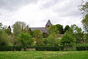
View of Roézé-sur-Sarthe

Saint-Pierre-et-Saint-Paul church

Sainte-Anne Hospice
.JPG)
.JPG)
.JPG)
Parish partnership
There is a partnership with the British community of Woodhall Spa in Lincolnshire (England).