
Louplande
| Louplande | ||
|---|---|---|
|
||
| region | Pays de la Loire | |
| Department | Sarthe | |
| Arrondissement | La Flèche | |
| Canton | La Suze-sur-Sarthe | |
| Community association | Val de Sarthe | |
| Coordinates | 47 ° 57 ' N , 0 ° 3' E | |
| height | 43-102 m | |
| surface | 18.47 km 2 | |
| Residents | 1,462 (January 1, 2017) | |
| Population density | 79 inhabitants / km 2 | |
| Post Code | 72210 | |
| INSEE code | 72169 | |
| Website | http://www.louplande.fr/ | |
 Louplande Town Hall (Mairie) |
||

Louplande is a French commune with 1,462 inhabitants (as of January 1 2017) in the department of Sarthe in the region Pays de la Loire . It belongs to the arrondissement of La Flèche and the canton of La Suze-sur-Sarthe . The inhabitants are called Louplandais .
geography
Louplande is about 13 kilometers southwest of Le Mans . Louplande is surrounded by the neighboring communities of Souligné-Flacé in the north and northwest, Étival-lès-le-Mans in the north and east, Voivres-lès-le-Mans in the south and southeast, Roézé-sur-Sarthe in the south and Chemiré-le- Gaudin to the west and south-west.
Population development
| year | 1962 | 1968 | 1975 | 1982 | 1990 | 1999 | 2006 | 2013 |
| Residents | 676 | 704 | 769 | 914 | 1,137 | 1,193 | 1,448 | 1,482 |
| Source: Cassini and INSEE | ||||||||
Attractions
- Saint-Léonard church, built at the end of the 19th century
- Villaines castle from the 17th century, monument historique since 1984

Louplande church
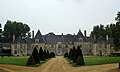
Villaines Castle


Web links
Commons : Louplande - collection of images, videos and audio files