Coulongé
| Coulongé | ||
|---|---|---|
|
|
||
| region | Pays de la Loire | |
| Department | Sarthe | |
| Arrondissement | La Flèche | |
| Canton | Le Lude | |
| Community association | South Sarthe | |
| Coordinates | 47 ° 41 ′ N , 0 ° 12 ′ E | |
| height | 47-107 m | |
| surface | 15.05 km 2 | |
| Residents | 519 (January 1, 2017) | |
| Population density | 34 inhabitants / km 2 | |
| Post Code | 72800 | |
| INSEE code | 72098 | |
Coulongé is a French municipality with 519 inhabitants (at January 1, 2017) in the Sarthe department in the region of Pays de la Loire ; it belongs to the arrondissement of La Flèche and the canton of Le Lude . Neighboring municipalities to Coulongé are: Le Lude , Aubigné-Racan , Sarcé , Pontvallain , Mansigné and Luché-Pringé .
Attractions
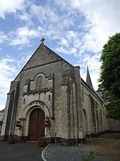
- St. Lubin Church (12th century)
- St. Hubert chapel
Web links
Commons : Coulongé - collection of images, videos and audio files

