
La Chapelle-aux-Choux
| La Chapelle-aux-Choux | ||
|---|---|---|
|
||
| region | Pays de la Loire | |
| Department | Sarthe | |
| Arrondissement | La Flèche | |
| Canton | Le Lude | |
| Community association | South Sarthe | |
| Coordinates | 47 ° 38 ' N , 0 ° 14' E | |
| height | 36-102 m | |
| surface | 14.43 km 2 | |
| Residents | 266 (January 1, 2017) | |
| Population density | 18 inhabitants / km 2 | |
| Post Code | 72800 | |
| INSEE code | 72060 | |

La Chapelle-aux-Choux is a French municipality with 266 inhabitants (as of January 1 2017) in the department of Sarthe in the region Pays de la Loire . It belongs to the arrondissement of La Flèche and the canton of Le Lude . The inhabitants are called chapellois .
geography
La Chapelle-aux-Choux is located about 38 kilometers south-southeast of Le Mans on the Loir River . La Chapelle-aux-Choux is surrounded by the neighboring communities of Aubigné-Racan in the north, Saint-Germain-d'Arcé in the east, Villiers-au-Bouin in the south and south-east, Noyant-Villages in the south and south-west and Le Lude in the west.
The former route nationale 159 (today's D306) runs through the municipality .
Population development
| year | 1962 | 1968 | 1975 | 1982 | 1990 | 1999 | 2006 | 2013 |
| Residents | 387 | 321 | 275 | 297 | 294 | 322 | 277 | 268 |
| Source: Cassini and INSEE | ||||||||
Attractions
- Church of Sainte-Geneviève, monument historique since 2002
- Saint-Pierre Chapel
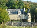
- La Châtaigneraie castle from the 19th century
- Manor of Le Perray

Saint-Pierre Chapel

La Châtaugneraie Castle
Le Perray mansion


literature
- Le Patrimoine des Communes de la Sarthe. Flohic Editions, Volume 1, Paris 2000, ISBN 2-84234-106-6 , pp. 725-727.