
Fercé-sur-Sarthe
| Fercé-sur-Sarthe | ||
|---|---|---|
|
||
| region | Pays de la Loire | |
| Department | Sarthe | |
| Arrondissement | La Flèche | |
| Canton | La Suze-sur-Sarthe | |
| Community association | Val de Sarthe | |
| Coordinates | 47 ° 54 ' N , 0 ° 2' E | |
| height | 32-81 m | |
| surface | 12.11 km 2 | |
| Residents | 593 (January 1, 2017) | |
| Population density | 49 inhabitants / km 2 | |
| Post Code | 72430 | |
| INSEE code | 72131 | |

Fercé-sur-Sarthe is a French municipality with 593 inhabitants (as of January 1 2017) in the department of Sarthe in the region Pays de la Loire . It belongs to the arrondissement of La Flèche and the canton of La Suze-sur-Sarthe . The inhabitants are called Fercéins .
geography
Fercé-sur-Sarthe is located about 19 kilometers southwest of Le Mans on the Sarthe , into which the Gée flows here. Fercé-sur-Sarthe is surrounded by the neighboring communities of Maigné in the north and north-west, Chemiré-le-Gaudin in the north and east, La Suze-sur-Sarthe in the east and south-east, Saint-Jean-du-Bois in the south, Noyen-sur -Sarthe in the southwest and Pirmil in the west.
Population development
| year | 1962 | 1968 | 1975 | 1982 | 1990 | 1999 | 2006 | 2013 |
| Residents | 322 | 317 | 322 | 458 | 512 | 490 | 597 | 593 |
| Source: Cassini and INSEE | ||||||||
Attractions
- Saint-Pierre church from the 12th century, renovations from the 15th and 17th centuries
- Chapel Saint-Roch from the 16th / 17th centuries century
- Vaulogé Castle

Saint-Etienne church

Saint Roch chapel
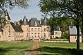
Vaulogé Castle
.JPG)

_01.JPG)
Web links
Commons : Fercé-sur-Sarthe - Collection of images, videos and audio files