
Villaines-sous-Malicorne
| Villaines-sous-Malicorne | ||
|---|---|---|
|
||
| region | Pays de la Loire | |
| Department | Sarthe | |
| Arrondissement | La Flèche | |
| Canton | La Flèche | |
| Community association | Pays Fléchois | |
| Coordinates | 47 ° 46 ′ N , 0 ° 6 ′ W | |
| height | 40-94 m | |
| surface | 19.16 km 2 | |
| Residents | 1,025 (January 1, 2017) | |
| Population density | 53 inhabitants / km 2 | |
| Post Code | 72270 | |
| INSEE code | 72377 | |
 Town hall ( Mairie ) of Villaines-sous-Malicorne |
||

Villaines-sous-Malicorne is a French commune with 1,025 inhabitants (as of January 1 2017) in the department of Sarthe in the region Pays de la Loire . It belongs to the arrondissement of La Flèche and the canton of La Flèche (until 2015: canton of Malicorne-sur-Sarthe ). The inhabitants are called Villainais .
geography
Villaines-sous-Malicorne is about 32 kilometers southwest of Le Mans . Villaines-sous-Malicorne is surrounded by the neighboring communities of Arthezé in the north, Bousse in the east, La Flèche in the south, Crosmières in the west and south-west and Le Bailleul in the west.
Population development
| 1962 | 1968 | 1975 | 1982 | 1990 | 1999 | 2006 | 2017 |
|---|---|---|---|---|---|---|---|
| 747 | 745 | 796 | 730 | 725 | 746 | 936 | 1025 |
| Sources: Cassini and INSEE | |||||||
Attractions
- Saint-Germain church from the 11th / 12th centuries Century, Monument historique
- L'Aubinière chapel
- Remains of a hill tower near La Roche-Simon
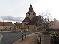
Saint Germain Church

L'Aubinière chapel


Web links
Commons : Villaines-sous-Malicorne - Collection of images, videos and audio files