
Viré-en-Champagne
| Viré-en-Champagne | ||
|---|---|---|
|
||
| region | Pays de la Loire | |
| Department | Sarthe | |
| Arrondissement | La Flèche | |
| Canton | Loué | |
| Community association | Loué-Brûlon-Noyen | |
| Coordinates | 47 ° 59 ′ N , 0 ° 17 ′ W | |
| height | 52-103 m | |
| surface | 11.48 km 2 | |
| Residents | 200 (January 1, 2017) | |
| Population density | 17 inhabitants / km 2 | |
| Post Code | 72350 | |
| INSEE code | 72379 | |
 Town hall (Mairie) of Viré-en-Champagne |
||

Viré-en-Champagne is a French commune of 200 inhabitants (as of January 1, 2017) in the department of Sarthe in the region Pays de la Loire . The municipality belongs to the arrondissement La Flèche and the canton Loué (until 2015: canton Brûlon ). The inhabitants are called Viréens .
geography
Viré-en-Champagne is about 35 kilometers west of Le Mans . Viré-en-Champagne is surrounded by the neighboring communities of Saint-Denis-d'Orques in the north, Avessé in the east and south-east, Cossé-en-Champagne in the south and west, Bannes in the west and Thorigné-en-Charnie in the north-west.
Population development
| 1962 | 1968 | 1975 | 1982 | 1990 | 1999 | 2006 | 2013 | |
|---|---|---|---|---|---|---|---|---|
| 392 | 342 | 237 | 190 | 193 | 164 | 228 | 231 | |
| Source: Cassini and INSEE | ||||||||
Attractions
- Saint-Etienne church from the 15th century
- Viré Castle, Monument historique since 1989
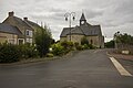
Saint-Etienne church
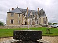
Viré Castle


literature
- Le Patrimoine des Communes de la Sarthe. Flohic Editions, Volume 1, Paris 2000, ISBN 2-84234-106-6 , pp. 335-337.
Web links
Commons : Viré-en-Champagne - Collection of images, videos and audio files