
La Chapelle-d'Aligné
| La Chapelle-d'Aligné | ||
|---|---|---|
|
||
| region | Pays de la Loire | |
| Department | Sarthe | |
| Arrondissement | La Flèche | |
| Canton | La Flèche | |
| Community association | Pays Fléchois | |
| Coordinates | 47 ° 44 ′ N , 0 ° 14 ′ W | |
| height | 28-67 m | |
| surface | 33.04 km 2 | |
| Residents | 1,694 (January 1, 2017) | |
| Population density | 51 inhabitants / km 2 | |
| Post Code | 72300 | |
| INSEE code | 72061 | |
| Website | http://lachapelledaligne.com/ | |
 Town hall (Mairie) of La Chapelle-d'Aligné |
||

La Chapelle-d'Aligné is a French commune with 1,694 inhabitants (at January 1, 2017) in the Sarthe department in the region of Pays de la Loire ; it is part of the arrondissement of La Flèche and the canton of La Flèche . The inhabitants are called chapellois .
geography

La Chapelle-d'Aligné is about 44 kilometers southwest of Le Mans . La Chapelle-d'Aligné is surrounded by the neighboring communities Louailles in the north, Le Bailleul in the northeast, Crosmières in the east, Durtal in the south, Notre-Dame-du-Pé in the southwest and Précigné in the west.
The A11 car route runs through the municipality . The Argance River , a tributary of the Loir, runs along the eastern municipal boundary .
Population development
| year | 1962 | 1968 | 1975 | 1982 | 1990 | 1999 | 2006 | 2013 |
|---|---|---|---|---|---|---|---|---|
| Residents | 1,235 | 1,148 | 1,067 | 1,041 | 1,098 | 1,165 | 1,342 | 1,613 |
| Source: Cassini and INSEE | ||||||||
Attractions
- Saint-Jean-Baptiste church
- 17th century castle and garden of Les Gringuières, Monument historique
- 15th century manor house Les Alignés
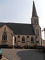
Saint-Jean-Baptiste church

Les Gringuières castle


literature
- Le Patrimoine des Communes de la Sarthe. Flohic Editions, Volume 1, Paris 2000, ISBN 2-84234-106-6 , pp. 520-525.
Web links
Commons : La Chapelle-d'Aligné - collection of images, videos and audio files