
Voivres-lès-le-Mans
| Voivres-lès-le-Mans | ||
|---|---|---|
|
||
| region | Pays de la Loire | |
| Department | Sarthe | |
| Arrondissement | La Flèche | |
| Canton | La Suze-sur-Sarthe | |
| Community association | Val de Sarthe | |
| Coordinates | 47 ° 56 ' N , 0 ° 4' E | |
| height | 37-74 m | |
| surface | 11.44 km 2 | |
| Residents | 1,377 (January 1, 2017) | |
| Population density | 120 inhabitants / km 2 | |
| Post Code | 72210 | |
| INSEE code | 72381 | |

Voivres-lès-le-Mans is a French commune with 1,377 inhabitants (as of January 1 2017) in the department of Sarthe in the region Pays de la Loire . It belongs to the arrondissement of La Flèche and the canton of La Suze-sur-Sarthe . The inhabitants are called Voivrais .
geography
Voivres-lès-le-Mans is about twelve kilometers southwest of Le Mans . Voivres-lès-le-Mans is surrounded by the neighboring communities Louplande in the north and west, Étival-lès-le-Mans in the north and north-east, Allonnes in the north-east, Spay in the east, Fillé in the south and south-east and Roézé-sur-Sarthe in the South and southwest. The place has a train stop on the Le Mans – Angers railway line .
Population development
| year | 1962 | 1968 | 1975 | 1982 | 1990 | 1999 | 2006 | 2013 |
| Residents | 547 | 600 | 614 | 712 | 773 | 846 | 1,098 | 1,276 |
| Source: Cassini and INSEE | ||||||||
Attractions
- Saint-Etienne church from the 12th century
- Perrière mansion from the 12th century
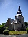
Saint-Etienne church

Manor Perrière


Web links
Commons : Voivres-lès-le-Mans - Collection of images, videos and audio files